Renewed activity at Veniaminof volcano, Aviation Color Code raised to Orange, Alaska
Low-level ash emissions from the summit of Veniaminof volcano, Alaska were observed in web camera views on April 5, 2021, the Alaska Volcano Observatory (AVO) reported at 20:49 UTC. Because of the renewed activity, AVO has raised the Aviation Color Code to ORANGE and the Volcano Alert Level to WATCH.
While some instances of elevated seismicity were noted there were no infrasound detections of explosions or surface activity.
Animation of FAA Perryville NW webcam images showing ash plumes from Veniaminof on April 5, 2021. Image credit: Hannah Dietterich, Perryville NW FAA webcam
Eruptive activity at Veniaminof usually consists of minor ash emissions, lava fountaining and lava flows from the small cone in the summit caldera.
Ash emissions are typically confined to the summit crater, but larger events can result in ashfall in nearby communities and drifting airborne ash.
The partial restoration of local seismic data will help the Alaska Volcano Observatory to detect changes in unrest that may lead to a more significant explosive eruption.
AVO combines seismic, infrasound, lightning, web camera, and satellite data for rapid detection of such events.
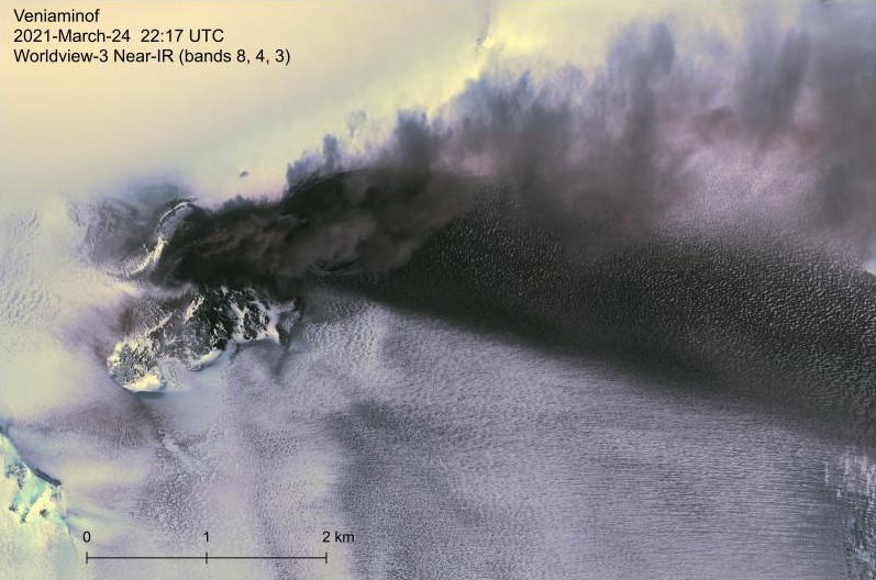
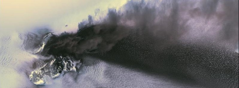
Worldview-3 near-IR satellite image of the Veniaminof eruption on March 24, 2021. Tephra deposits and an active ash plume are visible to the east of the summit cone. The 2018 lava flow field is visible south of the cone, while the 2021 lava flow ice cauldron is mostly obscured by the plume. Image credit: Matt Loewen/USGS, DigitalGlobe via NextView license
Geological summary
Veniaminof, on the Alaska Peninsula, is truncated by a steep-walled, 8 x 11 km (5 x 6.8 miles), glacier-filled caldera that formed around 3 700 years ago. The caldera rim is up to 520 m (1 706 feet) high on the north, is deeply notched on the west by Cone Glacier, and is covered by an ice sheet on the south.
Post-caldera vents are located along a NW-SE zone bisecting the caldera that extends 55 km (34 miles) from near the Bering Sea coast, across the caldera, and down the Pacific flank.
Historical eruptions probably all originated from the westernmost and most prominent of two intra-caldera cones, which rises about 300 m (984 feet) above the surrounding icefield.
The other cone is larger, and has a summit crater or caldera that may reach 2.5 km (1.5 miles) in diameter, but is more subdued and barely rises above the glacier surface.
Featured image credit: Matt Loewen/USGS, DigitalGlobe via NextView license
Commenting rules and guidelines
We value the thoughts and opinions of our readers and welcome healthy discussions on our website. In order to maintain a respectful and positive community, we ask that all commenters follow these rules.