Hurricane “Laura” aftermath: at least 54 people dead, widespread destruction across the Caribbean and US Gulf Coast
Hurricane "Laura" entered history books as a deadly, very powerful, and damaging hurricane that tied the Last Island Hurricane of 1856 as the strongest hurricane ever recorded to make landfall in Louisiana, U.S. Laura is the 12th named storm, 4th hurricane, and 1st major hurricane of the 2020 Atlantic hurricane season. At least 53 people were killed, as of August 30, 2020 — 31 in Haiti, 4 in the Dominican Republic and 18 in the United States (10 in Louisiana, 7 in Texas and 1 in Florida).
The storm started forming on August 16 as a tropical wave off the west coast of Africa. On August 20, satellite imagery revealed that the system developed a defined low-level circulation center, with convection firing up around it. As a result, the NHC began issuing advisories on Tropical Depression Thirteen, while the system was located about 1 670 km (1 035 miles) ESE of the northern Leeward Islands.
Schools were closed in Anguilla and Antigua on August 20 as well as all ports in the British Virgin Islands.
Laura intensified into a tropical storm on August 21 when it was about 375 km (230 miles) ESE of the northern Leeward Islands. This made it the earliest 12th named storm in the Atlantic Ocean on record, beating the previous record held by Hurricane "Luis" of 1995 by 8 days.
The storm was strengthening as it passed just south of Puerto Rico and early on August 23, it made landfall near San Pedro de Macoris, Dominican Republic with maximum sustained winds of 72 km/h (45 mph).
On the same day, it passed near Santo Domingo, the capital of the Dominican Republic, and emerged from Haiti and crossed the Windward Passage, making a second landfall near Santiago de Cuba Province, Cuba with maximum sustained winds of 95 km/h (60 mph) and a minimum central pressure of 1 000 hPa. The third landfall took place around 00:00 UTC on August 25 in western Cuba's Pinar del Rio Province. The storm then entered the Gulf of Mexico and started reorganizing.
Laura brought heavy rainfall to the islands of Guadeloupe and Dominica. In the Netherlands Antilles, Saba, Sint Eustatius, and Sint-Maarten saw minor flooding. Scattered power outages affected 4 000 people in Saint Kitts and Nevis. In the Virgin Islands, a peak wind gust of 65 km/h (41 mph) was reported in Sandy Point, Saint Croix. The Virgin Islands reported some power outages and flash flooding.
Puerto Rico authorities declared a state of emergency after roughly 200 000 customers lost power and nearly 14 000 access to running water. A peak 104 mm (4.09 inches) of rain was reported in Villalba and peak wind gust of 121 km/h (75 mph) in Salinas.
In the Dominican Republic, the heaviest rains were reported in the country's southern coast. The highest 24-hour rainfall accumulation was recorded in Barahona at 300 mm (11.7 inches). According to media reports, approximately 1.1 million people lost power, and 1.56 million experienced water service disruption. Estimates made on August 24 included 1 791 damaged homes. At least 4 people lost their lives.
Widespread flooding also hit Haiti where Peligre Dam overflowed, sending floodwaters down the Artibonite valley. Floods damaged 447 homes and destroyed 15 in the Artibonite. At least 31 people lost their lives and 8 went missing.
In Cuba, 260 000 people were forced to evacuate. A wind gust of 146 km/h (91 mph) was recorded in Maisi, where residents reported downed trees and destroyed roofs. 231.5 mm (9.51 inches) of rain was recorded in Complejo Palma, Santiago de Cuba, and 190.6 mm (7.50 inches) in San Antonio del Sura, Guantanamo. A bridge in Buey Arriba, Granma Province, collapsed due to flooding, stranding residents of 30 communities.
Flash flooding and significant disruption to road infrastructure were also reported across Jamaica.
Florida, U.S. started feeling Laura's effects by August 21, with major flooding and a state of emergency declared in southern counties. On August 25, a St. George Island first responder drowned while trying to rescue a swimmer caught in rough surf. This was Laura's first fatality in the United States.
Laura strengthened into a hurricane at 12:15 UTC on August 25 and started rapidly intensifying on the following day. At the time, the northern Gulf Coast was already under hurricane warnings caused by Hurricane "Marco."
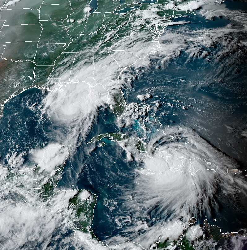
Tropical storms Marco (left) and Laura (right) at 22:00 UTC on August 23, 2020. Credit: NOAA/GOES-East, RAMMB/CIRA
Approximately 58% of oil production and 45% of natural gas were shut down in the United States by August 23. This included the evacuation of 114 platforms. By August 25, 299 of 643 platforms and 27 of 28 mobile rigs evacuated.
Three rare Extreme Wind Warnings were issued for Louisiana and Texas as Laura approached landfall.
Louisiana declared a state of emergency for 36 of its parishes on August 21 due to the combined effect of Marco and Laura. Evacuations related to Marco were in place for Plaquemines Parish, Jefferson Parish, Grand Isle, and Port Fourchon. A mandatory evacuation was ordered for the entire Calcasieu Parish on August 25 — approximately 200 000 people.
State of Emergency was declared in Texas on August 23 for 23 counties in its eastern region. Mandatory evacuation orders were issued for low-lying areas of Chambers, Galveston and Jefferson counties, and the entire Orange County. This included the entirety of the Bolivar Peninsula and cities of Galveston and Port Arthur. A voluntary evacuation order was issued for coastal areas of Brazoria and Harris counties. In total, an estimated 385 000 people were under evacuation orders in the state, including the entire city of Beaumont.
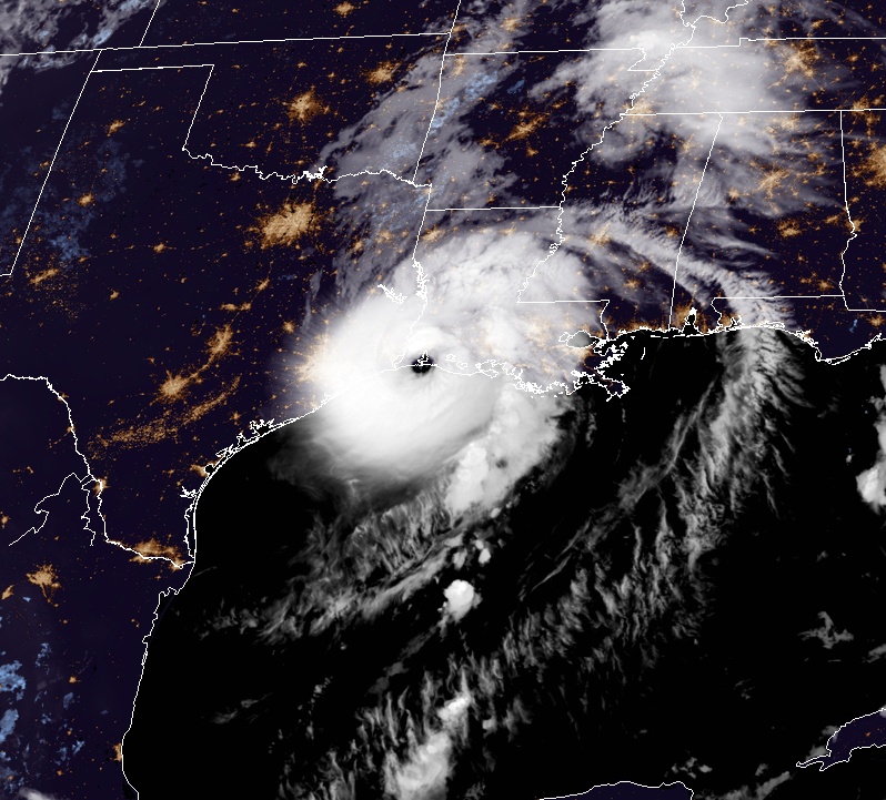
At 12:00 UTC on August 26, Laura intensified into a Category 3 hurricane and reached Category 4 strength by 18:00 UTC on the same day.
At 01:00 UTC on August 27, Laura reached a peak intensity of 240 km/h (150 mph) and pressure of 937 hPa. By 03:00 UTC, the pressure began to fluctuate as the storm approached the Louisiana coastline.
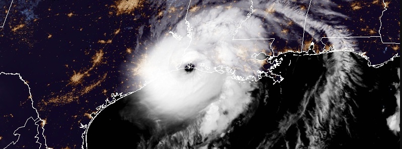
Hurricane "Laura" at 05:40 UTC on August 27, 2020. Credit: NOAA/GOES-East, RAMMB/CIRA
Laura made its fourth landfall near Cameron, Louisiana, with maximum sustained wind of 240 km/h (150 mph) and central pressure of 938 hPa at 06:00 UTC on August 27. This tied it with the 1856 Last Island hurricane as the strongest cyclone on record to make landfall in Louisiana, based on maximum sustained wind speed.

Read more: Category 4 Hurricane "Laura" ties for strongest Louisiana landfalling hurricane on record
It began to weaken quickly after moving inland due to frictional displacement and shear created by the trough that caused Hurricane "Marco" to dissipate two days earlier and became a tropical storm on the same day, while moving over northern Louisiana. Early on August 28, the storm weakened further, dropping to tropical depression status while over Arkansas. By that time, it was moving north-northeastward ahead of the westerly flow.
NHC issued its last advisory for the storm at 09:00 UTC on August 29 when Laura degraded into a remnant low, 210 km (130 miles) E of Louisville, Kentucky.
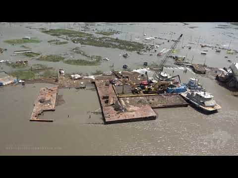
Widespread power outages were reported near the landfall point in Cameron. Near Cameron, a wind gust of 204 km/h (127 mph) was recorded at Calcasieu Pass, which saw at least 2.8 m (9.19 feet) of storm surge. Extensive damage took place in Holly Beach:

The Lake Charles Regional Airport saw a wind gust of 206 km/h (128 mph) and reported multiple hangars destroyed. Many windows were blown out of Capital One Tower in Downtown Lake Charles.


A communications tower collapsed onto the KPLC studio building (which had been evacuated ahead of the storm) and a portion of a sky bridge was blown out.
The radar at the NWS Lake Charles forecast office was destroyed around the time of landfall, with its dome and much of its internal equipment sheared from the radar tower's base. Its staff was evacuated before the incident.
A large chemical fire started on the west side of Lake Charles after a chlorine leak. Extensive structural damage was also reported in Vinton in De Quincy and much of the town of Delcambre.
Widespread flooding was also reported in Natchitoches Parish, where I-49 had to be closed past SH 174 west of Powhatan due to a downed tree.
Authorities reported four fatalities across the state due to falling trees. One young person died in Calcasieu Parish and the entire family of 4 in Lake Charles due to carbon monoxide poisoning from generators run inside homes. The 10th fatality in the state as man who drowned while aboard a sinking boat during the storm.


One person was killed and another injured in Texas before Laura made landfall after a rough surf slammed them against jetties on August 26. Another man reportedly died after he was electrocuted while preparing for the storm. Another person lost its life after a tree fell on him while he was sitting on a recliner in his home. Southeast Texas registered 4 fatalities in three separate incidents of carbon monoxide poisoning, bringing the state's death toll to 7.

Mississippi reported 1 tornado and widespread flooding across Jefferson Davis County but other than that, the state was spared of devastating storm surge forecasters warned about.
A large and extremely dangerous tornado was reported in Crowley's Ridge State Park, Arkansas, prompting a rare Particularly Dangerous Situation tornado warning. An EF-2 tornado was also reported southwest of Maynard and another in Lake City, causing significant damage.
Over a million customers lost power in the United States and about 200 000 without running water.


Featured image: Category 4 Hurricane "Laura" making landfall in Louisiana. Credit: NOAA/GOES-East. Acquired 05:40 UTC on August 27, 2020.
Notice, there are more comments of people with sympathy towards 19 water buffalo than 54 dead and 25% of a state with no power.
So, “Normies”, pay those taxes, get denounced for inadvertently producing carbon, and get ready for virtue signaling from the pontificating class.