Category 4 Hurricane “Laura” ties for strongest Louisiana landfalling hurricane on record
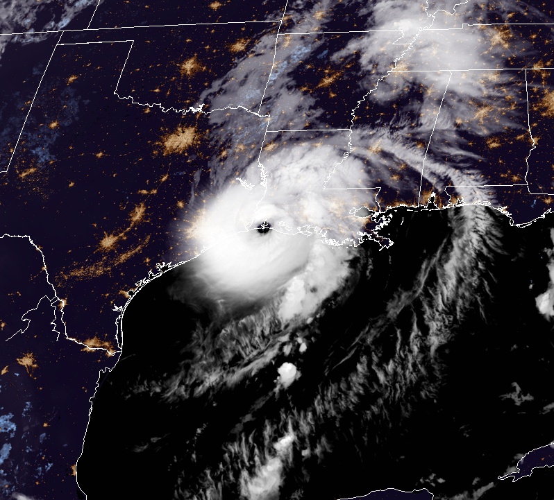
Category 4 Hurricane "Laura" made landfall near Cameron in southwestern Louisiana at 06:00 UTC (01:00 CDT) on August 27, 2020, with maximum sustained winds of 241 km/h (150 mph) and minimum central pressure of 938 hPa. Catastrophic storm surge, extreme winds, and flash flooding are occurring in portions of Louisiana.
Laura is the strongest hurricane to make landfall in Louisiana since the Last Island Hurricane of 1856. Last Island also had maximum sustained winds of 241 km/h (150 mph) – tie for the strongest Louisiana landfalling hurricane on record.
The table below, made by Dr. Philip Klotzbach of the CSU, shows 11 strongest hurricanes to make landfall in Louisiana since records began in 1851, based on maximum sustained wind.
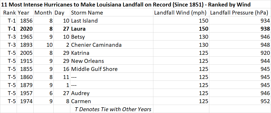
Image courtesy Dr. Philip Klotzbach
Laura's minimum central pressure of 938 hPa is the 4th lowest for a Louisiana hurricane landfall on record, trailing Katrina (2005, 920 hPa), Last Island (1856, 934 hPa) and Rita (2005, 937 hPa), Klotzbach noted.
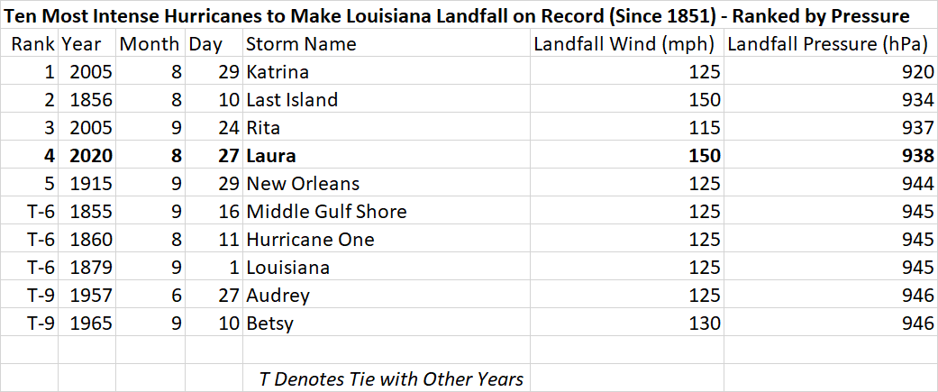
Image courtesy Dr. Philip Klotzbach
Laura is also the 7th named storm to make landfall in continental US (CONUS) in 2020, breaking the old record of 6 named storms making CONUS landfall by the end of August, set in 1886 and 1916.
It is also the 7th major hurricane (Category 3+) to hit the state of Louisiana during August since records began in 1851.
"Louisiana has been hit by more major hurricanes during August than any other state except Texas," Klotzbach said.
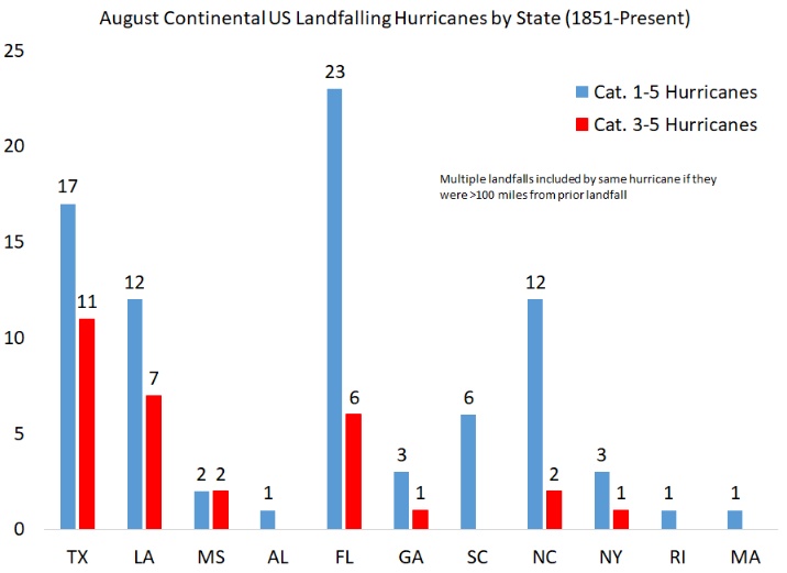
Image courtesy Dr. Philip Klotzbach
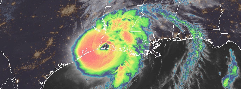
Hurricane "Laura" at 05:40 UTC on August 27, 2020. Credit: NOAA/GOES-East, RAMMB/CIRA
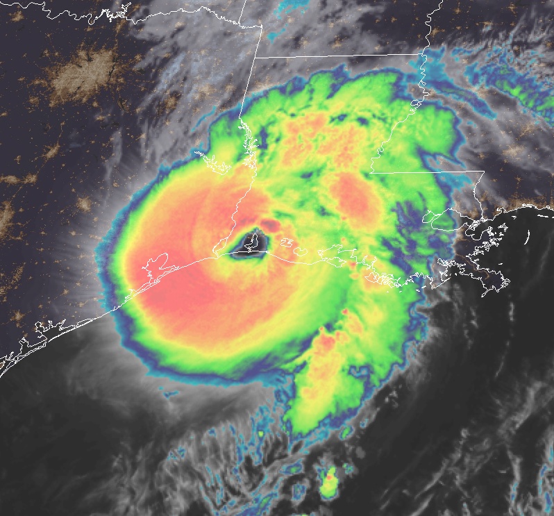
Hurricane "Laura" at 06:00 UTC on August 27, 2020. Credit: NOAA/GOES-East, RAMMB/CIRA
At the time of landfall, at 06:00 UTC today, the center of Hurricane "Laura" was about 45 km (30 miles) SSW of Lake Charles, Louisiana and 70 km (40 miles) E of Port Arthur, Texas.
The storm was moving N at 24 km/h (15 mph) and this general motion should continue through the day. A northeastward to east-northeastward motion is expected tonight and Friday.
On the forecast track, Laura will move inland across southwestern Louisiana this morning, and then continue northward across the state through this afternoon. The center of Laura is forecast to move over Arkansas tonight, and over the mid-Mississippi Valley on Friday, and the mid-Atlantic states on Saturday.
Hurricane-force winds extend outward up to 95 km (60 miles) from the center and tropical-storm-force winds extend outward up to 335 km (205 miles).

A Weatherflow site in Cameron recently reported a sustained wind of 163 km/h (101 mph) with a gust to 187 km/h (116 mph).
A National Ocean Service site at Calcasieu Pass reported a sustained wind of 150 km/h (93 mph) and a wind gust of 204 km/h (127 mph) within the last hour.
A wind gust of 167 km/h (104 mph) was recently reported at Lake Charles, Louisiana.

At 07:00 UTC, Laura's center was about 15 km (10 miles) SW of Lake Charles. It had maximum sustained winds of 225 km/h (140 mph) and minimum central pressure of 941 hPa. The storm was moving N at 24 km/h (15 mph). By 08:00 UTC, it was 25 km (15 miles) WNW of Lake Charles with maximum sustained winds of 210 km/h (130 mph) and minimum central pressure of 946 hPa.
A National Ocean Service tide station at Calcasieu Pass, Louisiana observed a water level rise of 2.8 m (9.19 feet) Mean Higher High Water at 06:00 UTC (01:00 CDT).
In Lake Charles, Louisiana, the airport reported a sustained wind of 158 km/h (98 mph) with a gust to 212 km/h (132 mph) and a University of Florida observing tower reported sustained winds of 153 km/h (95 mph) and a gust to 212 km/h (132 mph) within the past couple of hours.
A Weatherflow site in Cameron, Louisiana reported sustained wind of 148 km/h (92 mph) and a gust to 188 km/h (117 mph) in the southern eyewall of Laura after the eye has passed overhead.

Featured image: Hurricane "Laura" at 06:00 UTC on August 27, 2020. Credit: NOAA/GOES-East, RAMMB/CIRA
To day is now the 17th on the native 40 day calendar or the 24th on a full moon to full moon calendar, so the 29th or the 29th /23/ 3/ will be a good day to harvest corn ones it cools down because of the storms coming.