Hurricane “Douglas” continues WNW toward Hawaii, pre-landfall emergency issued
Category 2 Hurricane "Douglas" continues moving WNW toward Hawaii and is expected to be near hurricane strength when it nears the islands Saturday night (LT) through Sunday, July 25 and 26, 2020.
Key messages issued by NHC:
- Douglas continues to approach the main Hawaiian Islands, potentially passing dangerously close to, or over, the islands Saturday night through Sunday night. The close passage of Douglas brings a triple threat of hazards, including but not limited to damaging winds, flooding rainfall, and dangerously high surf, especially along east facing shores.
- It is vital that you do not focus on the exact forecast track or intensity of Douglas, and remain prepared for changes to the forecast. Due to Douglas' angle of approach to the islands, any small changes in the track could lead to significant differences in where the worst weather occurs. Even if the center remains offshore, severe impacts could still be realized over the islands, as they extend well away from the center.
- Terrain effects can cause strong localized acceleration of the wind through gaps and where winds blow downslope. These acceleration areas will shift with time as Douglas passes near the islands. Winds will also be stronger at the upper floors of high rise buildings.
A Tropical Storm Warning and Hurricane Watch are in effect for Hawaii County; and Maui County, including the islands of Maui, Lanai, Molokai and Kahoolawe. A Hurricane Watch is in effect for Oahu.
Governor David Ige issued a pre-landfall emergency proclamation on July 23 as the state prepared for Hurricane Douglas. The proclamation authorized the expenditure of state funds for the quick and efficient relief of disaster-related damage, losses and suffering that may result from the storm.
"Our top priority is always the safety, health and well-being of our residents and visitors. Please take immediate steps to protect your families, loved ones, employees, and property. We ask everyone to closely follow emergency instructions as we prepare for Hurricane Douglas," Ige said.
The disaster emergency relief period will continue through July 31, 2020
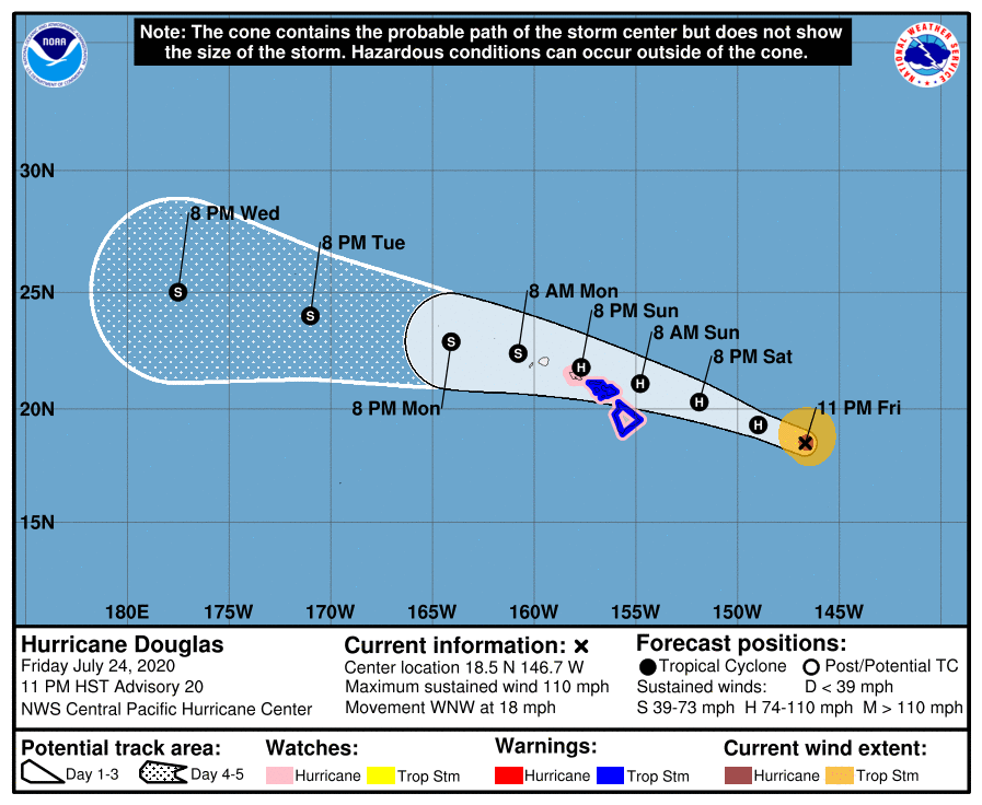
At 12:00 UTC on July 25, the center of Hurricane "Douglas" was located 780 km (485 miles) E of Hilo and 1 105 km (690 miles) ESE of Honolulu, Hawaii. The system had maximum sustained winds of 175 km/h (110 mph) and was moving WNW at 30 km/h (18 mph). Its minimum central pressure was 973 hPa.
This motion is expected to continue through Saturday, followed by a slight decrease in forward speed and a turn toward the west.
On the forecast track, Douglas will be near the main Hawaiian Islands Saturday night through Sunday night.
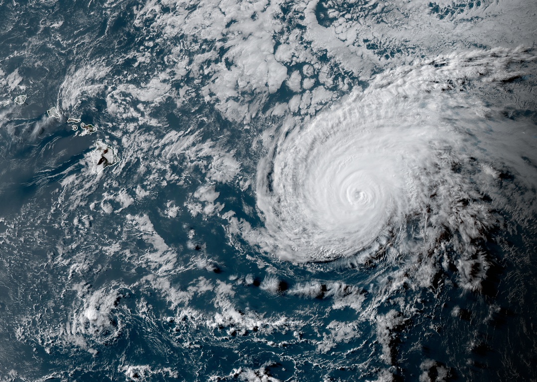
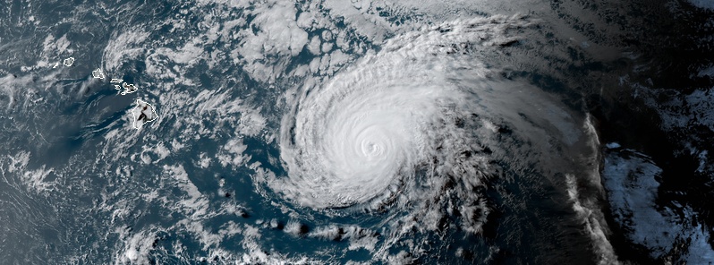
Hurricane "Douglas" at 03:00 UTC on July 25, 2020. Credit: NOAA/GOES-West, RAMMB/CIRA
Central Pacific Hurricane Center (CPHC) is urging residents not to focus on the forecast track but to recognize that much of the state is still in danger of impacts.
"Due to Douglas’ angle of approach to the islands, any small changes in the track could lead to significant differences in where the worst weather occurs. Even if the center remains offshore, severe impacts could still be realized over the islands."
Hurricane conditions are possible across portions of the main Hawaiian Islands late Saturday night through Monday, NHC forecaster Jelsema noted.
Tropical Storm conditions are expected across Hawaii County and Maui County beginning Saturday night or Sunday.
Large swells generated by Douglas are expected to affect the Hawaiian Islands this weekend. These swells are likely to cause life-threatening surf and rip current conditions for a couple of days.
Heavy rainfall associated with Douglas is expected to affect portions of the main Hawaiian Islands from late Saturday night through Monday.
Total rain accumulations of 125 – 250 mm (5 to 10 inches) with locally higher amounts will be possible on the smaller islands, especially across elevated terrain. This rain may result in life-threatening flash flooding and landslides, as well as rapid water level rises on small streams.
75 to 150 mm (3 to 6 inches) of rainfall are possible on the Big Island, with locally higher amounts.
Featured image: Hurricane "Douglas" at 03:00 UTC on July 25, 2020. Credit: NOAA/GOES-West, RAMMB/CIRA
Today is truly the 20th on a full moon calendar so it will hit on the 21st of the great year of 360 days of years equaling
3600 ÷3 = 1200/1200/1200/ this is a last of a sical of the years of this lower world / ( Hell ) ending on July 30 2020 so this one coming will not be a good one at all! Be ready !
What the heck??
Lower world?
I reckon we are in hell, but what lower world?