Tropical Storm “Fay” forms just off the coast of North Carolina, bringing heavy rains and strong winds to Mid-Atlantic coast and New England
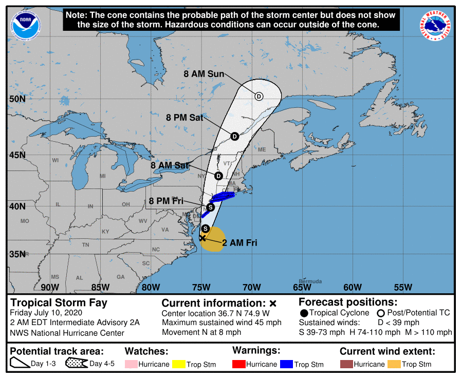
Tropical Storm "Fay" formed at 21:00 UTC on July 9, 2020, just off the coast of North Carolina, U.S. as the 6th named storm of the 2020 Atlantic hurricane season. The center of Fay is forecast to move near the Mid-Atlantic coast today and move inland over the mid-Atlantic or the northeast United States late tonight or on Saturday, July 11, bringing heavy rain and strong winds.
Fay is the earliest 6th named storm in the Atlantic Ocean on record and comes on the heels of Tropical Storm "Edouard" — the 5th earliest named storm in the Atlantic. The previous 6th named storm record holder was Franklin on July 22, 2005, and the 5th was Emily on July 12, 2005.
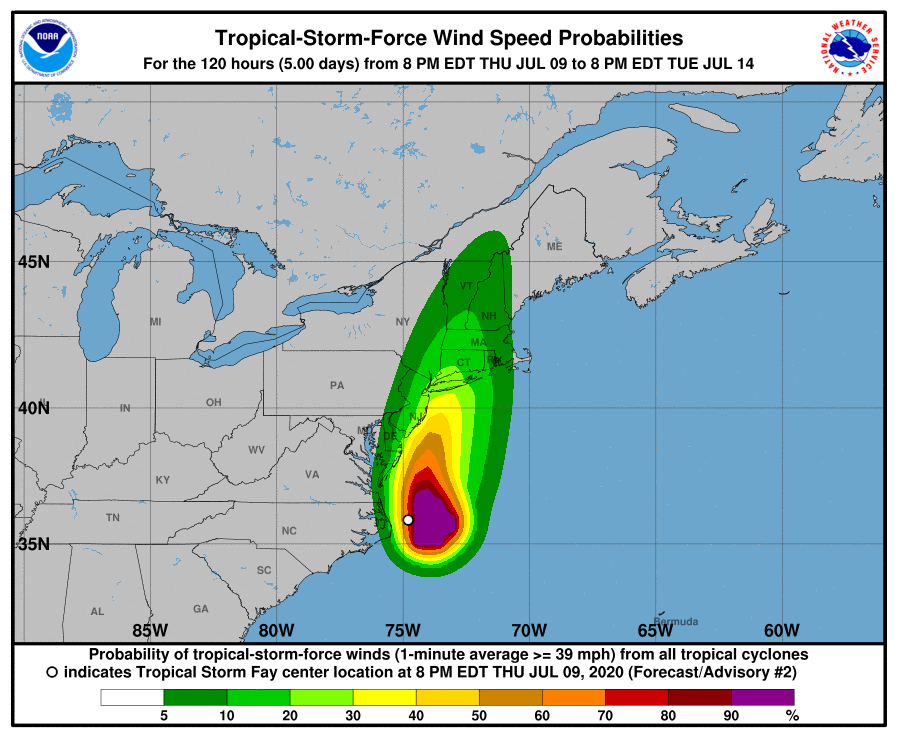
Impacts from this system will extend across parts of the Mid-Atlantic into Southern New England including moderate to locally heavy rainfall and flash flood potential near and north of its track, gusty winds, and rough surf along the coast, NWS said.
At the time it formed, Fay was 65 km (40 miles) ENE of Cape Hatteras, North Carolina, and 310 km (195 miles) S of Ocean City, Maryland.
By 06:00 UTC, it was located about 170 km (105 miles) S of Ocean City and 235 km (145 miles) S of Cape May, New Jersey.
The storm had maximum sustained winds of 75 km/h (45 mph) and was moving north at 13 km/h (8 mph). Its minimum central pressure was 1 005 hPa.
A Tropical Storm Warning is in effect for Cape May, New Jersey to Watch Hill, Rhode Island, including Long Island and Long Island Sound.
A northward to north-northeastward motion at a faster forward speed is expected over the next couple of days, NWS forecaster Pasch noted.
On the forecast track, the center of Fay is forecast to move near the Mid-Atlantic coast today and move inland over the mid-Atlantic or the northeast United States late tonight (LT) or on Saturday, July 10.
Little change in strength is forecast today and tonight while the center remains over water. Weakening should begin after the center moves inland.
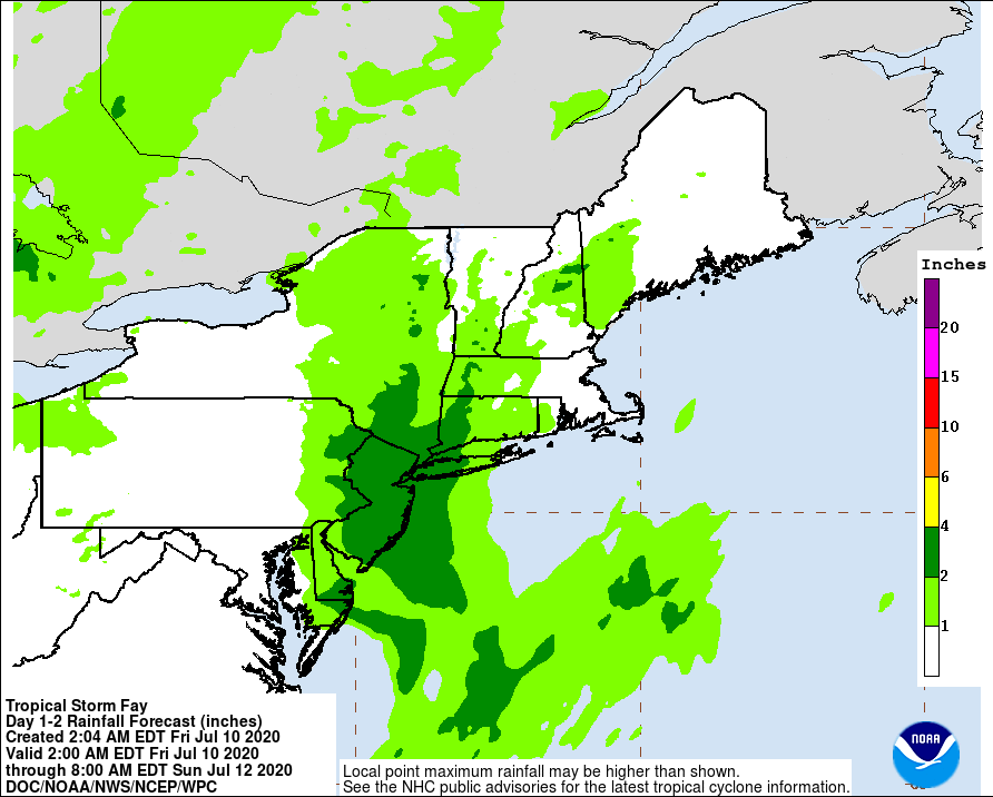
Fay is expected to produce 75 – 125 mm (3 to 5 inches) of rain with isolated maxima of 205 mm (8 inches) along and near its track across the Mid-Atlantic states into southeast New York and southern New England.
These rains may result in flash flooding where the heaviest amounts occur.
Tropical storm conditions are expected to first reach the coast within the warning area today and spread northward through the warning area tonight.
Minor flooding is possible along the coast for portions of the Tropical Storm Warning area.
Isolated tornadoes are possible today over portions of New Jersey, southeast New York, and southern New England.
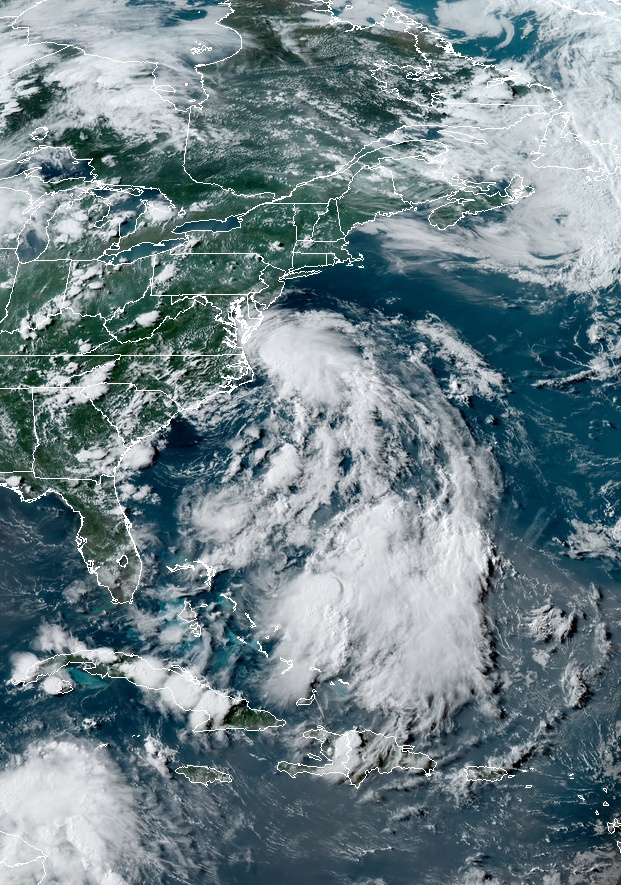
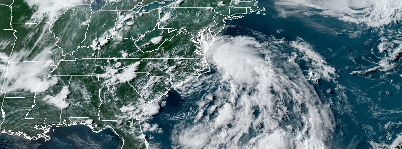
Tropical Storm "Fay" at 21:40 UTC on July 10, 2020. Credit: NOAA/GOES-East, RAMMB/CIRA
According to Dr. Philip Klotzbach, a meteorologist at CSU specializing in Atlantic basin seasonal hurricane forecasts, the first 5 Atlantic named storms of 2020 generated a measly 6.7 ACE (Accumulated Cyclone Energy — ACE — an integrated metric that accounts for intensity and duration).
Only 2 Atlantic hurricane seasons on record (since 1851) have had less ACE from 1st 5 storms of the year: 2017 and 1988.
Basically, the first 5 Atlantic named storms of 2020 have been quite weak and of relatively short duration, Klotzbach noted.
The Colorado State University (CSU) has chosen 6 analogs for its July seasonal hurricane forecast: 1966, 1995, 2003, 2008, 2011, and 2016. All of these years had above-average Atlantic hurricane activity and were generally characterized by cool neutral ENSO or La Nina conditions and warm tropical Atlantic.
Another reason for the active CSU Atlantic hurricane season forecast is odds of El Nino this summer/fall are extremely low. Tropical eastern and central Pacific remain cooler than normal. Atmospheric circulation is looking more La Nina-like with suppressed convection near the dateline.
Featured image: Tropical Storm "Fay" at 21:40 UTC on July 10, 2020. Credit: NOAA/GOES-East, RAMMB/CIRA
we are in the last days…for anyone who sees this and doesnt know what to do please If you havent given your life and heart to Christ Jesus you will have REAL Big problems way bigger than any problems you have Ever had If you are left here on earth after the Rapture . After the Rapture The USA , Worldwide , will face More evils than it Has EVER seen Before and you surely dont want to be Here then . We Have Time NOW to change , please seek Christ Jesus while there is still time to save ! no one knows the day or hour of the rapture ,But the rapture will start out just like any other day …..The Rapture will Take Place In the day In Broad daylight, sunny day so No One can refute it has taken place, The Rapture can Take place anytime NOW ,But we may have several years left but not many more , as many are turning to Jesus and there is a revival taking place and many still being brought into the Glorious kingdom of Jesus and Until the last soul is accounted for , is all that is preventing the rapture from happening. We are close , Several years goes by quickly so we are very close !