Fatal tornadoes leave destructive path through west-central Minnesota, U.S.
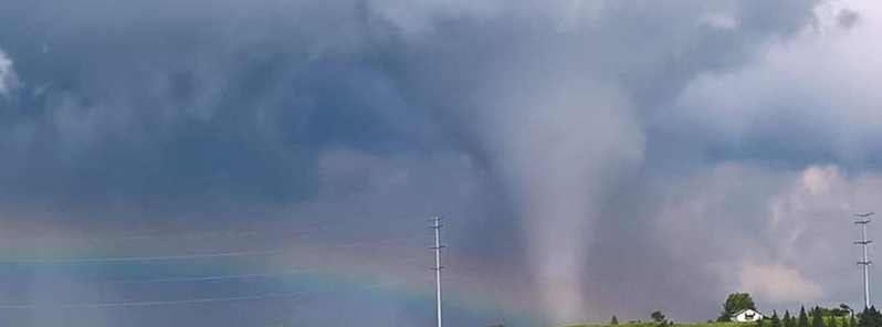
Two destructive tornadoes ripped through west-central Minnesota's Otter Tail County on Wednesday, July 8, 2020, leaving several properties damaged, including farmhouses, cars, and houses. An official confirmed one fatality and two other people injured.
The storms struck between 22:10 to 22:30 UTC (17:10 to 17:30 LT) near Dalton. Several homes and farmsteads in a rural area were either severely damaged or totally destroyed by the back-to-back twisters, including one farmhouse, which was flattened. Cars were also hit as trees were downed, as well as power lines.
Otter Tail County sheriff Barry Fitzgibbons confirmed one fatality and two people injured, who were taken to a hospital but their conditions remain unknown.
Ashby Mayor Tom Grover, who was working with volunteer rescue personnel in the tornado’s aftermath, said at least three farmsteads were "pretty much gone."
"I saw it come down, and right away, you could see the debris rising up," Grover told the Minneapolis Star-Tribune.


Alissa Wilbur and Paige Fode, who were able to capture the storm on their phones, said they were driving from the Twin Cities on their way to Grand Forks. They received a storm alert early evening but did not expect a tornado to touch down.
"It was definitely an experience, very scary," said Wilbur. "It kind of got in front of us a little bit. Thankfully it veered to the right and went into those fields."
The two added that the tornado was on the ground for around 20 minutes, based on what they could see.
"We didn’t see any damage, but once we got to the part of the interstate that it did cross, you could tell because there was water everywhere. It had picked up water from some lake or something," Fode stated. The water Fode described was likely from the Pelican River.


Another witness named JoAnn Beardsley said she and her grandchildren were down the lake when they saw what "looked like it was coming out of the clouds, and then a funnel formed inside."
"I figured it had to be a pretty monstrous tornado because I’m probably at least 4 to 5 km (3 to 4 miles) from where it would drop down."
The National Weather Service (NWS) went to the scene to survey the aftermath. The tornadoes are believed to be at least in the EF-3 category, with winds of 219 to 165 km/h (136 to 165 mph). Additional surveying will be done to determine the final preliminary rating.
NWS advises people to get to a sturdy indoor shelter immediately, in the event of a tornado, or drive into a low-riding ditch, then get down and cover your heads.
Incredible day to put it mildly! Caught my 100th #tornado near Dalton, Minnesota. Slow moving and well behaved enough that we were able to drive right up to it. #mnwx #stormchasing with the @_TwisterSisters pic.twitter.com/5pa78JxW2o
— Brad Nelson (@Brad_nado) July 9, 2020
TORNADO near Dalton, MN today!!! 7/8/20. #TORNADOWARNING #minnesota pic.twitter.com/dHNAUHE5Sl
— Twister Sisters (@_TwisterSisters) July 8, 2020
@MorningsMaria whoa maria ! just turned on weather channel , dere wuz a deadly tornado out west in OTTER TAIL COUNTY in my home state of minnesota … pic.twitter.com/m0lMjavNBO
— ye olde gasse bagge (@realgofer) July 9, 2020
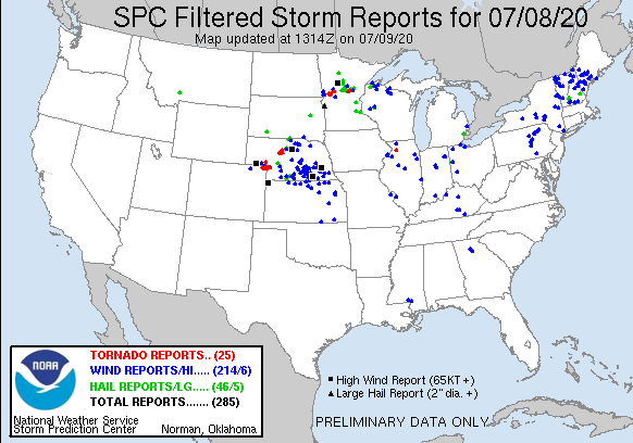
Overall, the NWS Storm Prediction Center received 27 tornado reports on July 8. This included 13 from Nebraska, seven from Minnesota, six from Colorado–where the extent of property damage is currently unknown– and one from Illinois.
Featured image credit: @realgofer/Twitter
tornadoes-damage-powerful-supercell