Scientists create 3D images of geological processes below Earth’s surface
Geoscientists at the University of Texas at Dallas generated high-resolution, 3D images of the dynamic geological processes that are happening far below the Earth's surface. The team described in the study how they created images of mantle flows in a subduction zone under Central America and the Caribbean Sea using a full waveform inversion (FWI)– a computationally intensive technique.
"This is the first comprehensive seismic study to directly image 3D mantle flow fields in actual subduction environments using advanced FWI technology," said co-author Dr. Hejun Zhu, also an assistant professor of geosciences in the School of Natural Sciences and Mathematics.
Earth's crust is broken into tectonic plates that move across and into the mantle very slowly. One plate descends under another into the mantle at regions called subduction zones.
"The sinking of oceanic plates into the Earth's mantle at subduction zones is what causes the Earth's tectonic plates to move and is one of the most important processes taking place in our planet," Zhu explained.
"Subduction zones are also the source of many natural hazards, such as earthquakes, volcanoes, and tsunamis. But the pattern of mantle flow and deformation around descending plates is still poorly understood. The information our techniques yield is crucial for understanding our dynamic planet."
The researchers addressed the problem by using seismic anisotropy, which measures the difference in how fast mechanical waves produced by tremors travel in different directions inside the Earth.
"When a diver dives into the water, the water separates, and that separation, in turn, affects the way the water moves around the swimmer," said Zhu.
"It's similar to oceanic plates: When they dive into the hot mantle, that action induces mantle separation and flow around the plates."
The team generated the images using high-fidelity data recorded over a 10-year period, from 180 quakes by around 4 500 seismic stations in a grid across the U.S.
The numerical calculations for the FWI algorithm were done on the high-performance computing clusters at the National Science Foundation (NSF) supported Texas Advanced Computing Center at UT Austin, as well as on supercomputers at UT Dallas.
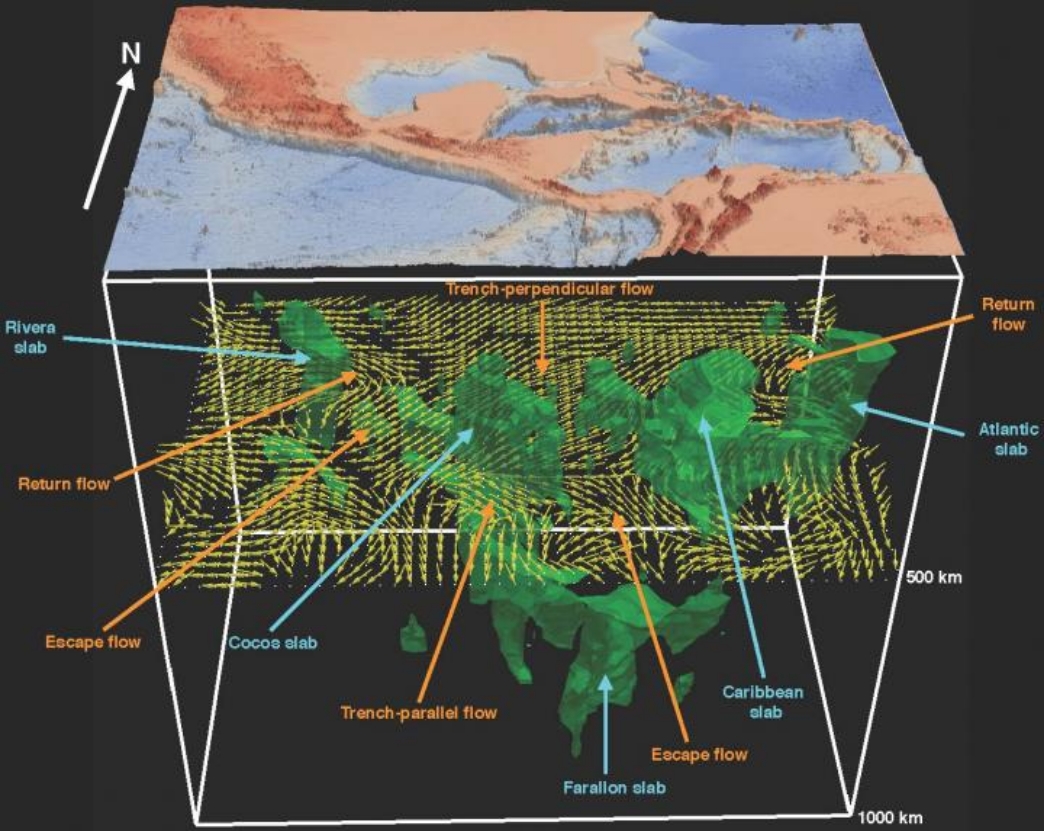
Image credit: The University of Texas at Dallas
"Previously we couldn't 'see' under the Earth's surface, but by using this technology and this very wonderful data set, we are able to delineate the 3D distribution of various seismic phenomena and tell at what depths they are occurring," Zhu stated.
The images confirmed that the plates in the region are not huge, solid pieces, but are fragmented into smaller slabs.
"This looks different from the textbook depictions of tectonic plates coming together, with one solid piece of oceanic plate descending under another solid piece," Zhu indicated.
"Some researchers have hypothesized that this fragmentation occurs, and our imaging and modeling provides evidence that supports that view."
Zhu's 3D model shows complex mantle flow patterns around descending fragments and in the gaps between slabs. For instance, the Juan de Fuca Plate in the northwestern U.S. is also fragmented into two pieces where it goes under the North American Plate in the Cascadia subduction zone.
"We know that most earthquakes happen at the interface between a slab and the mantle. If there is a gap between these fragments, what's called a window region, you wouldn't expect earthquakes there," Zhu further explained.
"If you look at the earthquake distribution along the Cascadia subduction zone, there is a span where you do not have earthquakes. That is probably a region where there is a gap in the subducting oceanic plate."
"The Middle America Trench that we studied has its own unique, dynamic properties. In the future, we plan to shift our attention to other subduction zones, including the Kermadec-Tonga subduction zone in the region of the Australian and Pacific plates."
Reference
"Seismic evidence for subduction-induced mantle flows underneath Middle America" – Zhu, H. et al. – Nature Communications – https://doi.org/10.1038/s41467-020-15492-6
Abstract
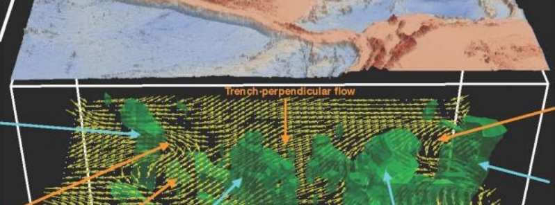
Laboratory experiments and geodynamic simulations demonstrate that poloidal- and toroidal-mode mantle flows develop around subduction zones. Here, we use a new 3-D azimuthal anisotropy model constructed by full-waveform inversion, to infer deep subduction-induced mantle flows underneath Middle America. At depths shallower than 150 km (93 miles), poloidal-mode flow is perpendicular to the trajectory of the Middle American Trench. From 300 to 450 km (186 to 280 miles) depth, return flows surround the edges of the Rivera and Atlantic slabs, while escape flows are inferred through slab windows beneath Panama and central Mexico. Furthermore, at 700 km (435 miles) depth, the study region is dominated by the Farallon anomaly, with fast axes perpendicular to its strike, suggesting the development of lattice-preferred orientations by substantial stress. These observations provide depth-dependent seismic anisotropy for future mantle flow simulations and call for further investigations about the deformation mechanisms and elasticity of minerals in the transition zone and uppermost lower mantle.
Featured image credit: The University of Texas at Dallas
Unfortunately, in general, academic research and scientists in several countries are no longer deserving of the public trust. In this case, marine trenches do exist and are used as tools for the concept of subduction zones, but their nature is based upon sloppy interpretations of seismological data. Subduction zones are generally depicted as dozens of kilometres’ thick slabs descending into the Earth. This “descent” is controversial from the perspective of physical laws. Subduction zones have the issue of overlooking the fact that frictional forces, required for subduction to occur are enormous and rarely do Earth scientists address this problem. Not only is energy not present to initiate subduction, but the required energy to sustain subduction is not available. The lack of a necessary rigidity does not allow oceanic crust’s materials of density 3.0 to be forced down through continental crust’s materials of density 2.67. Friction causes heath and plate tectonicists admit that it is hard to see, how the subduction of a cold slab could result in the high heat flow or island arc volcanism. The very low level of seismicity, the lack of a megathrust and the existence of flat-lying sediments; at the base of oceanic trenches contradict the alleged presence of a downgoing slab. Also, there is a thinning and necking in areas of trenching and other topographic evidence that indicates the trenches are tensional rifts not compressional features (Carey, 1976). In this study, Dr Zhu proposes a trivial project with often non-scientific end-results, such as the widespread practice of making a model based upon assumptions, instead of making discoveries based on observable empirical findings. Dr Zhu neglects the fundamental limitations of, and uncertainties in; seismic tomography results. These limitations and uncertainties involve theory, correcting for the crust, the lack of rays throughout much of the mantle and core, the difficulty in obtaining the true strength of anomalies and the choice of what background model, to subtract to reveal anomalies. Dr Zhu ignores the tensional regime in oceanic trenches as recorded by seismic analysis, normal fault deformation of oceanic plates beneath them and beneath the frontal part of island arcs, and much lower thickness of the Wadati – Benioff zone than thickness of oceanic plate. His “study” is another example of junk science that proliferates today in “scientific” journals which are misleading the public. Most scientific studies are wrong, and they are wrong because scientists are interested in funding and careers rather than truth. Many scientific “truths” are, in fact, false.