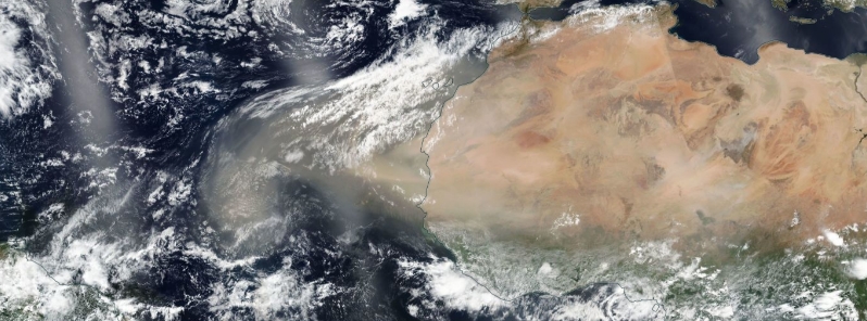
Massive plume of Saharan dust moving over the Atlantic Ocean toward the Caribbean and U.S.
An expansive plume of dust from the Sahara continues to move over the Atlantic Ocean and is forecast to spread to the Caribbean by the weekend. It may also reach the Gulf of Mexico and parts of the U.S. by next week.
The Saharan Air Layer (SAL) usually forms from late spring through early fall and moves into the tropical Atlantic Ocean every three to five days, according to NOAA's Hurricane Research Division.
NOAA program scientist Dan Lindsay posted an animation from Tuesday, June 16, which showed an expansive area of dust moving from Africa to the central and eastern tropical Atlantic Ocean.
"The Saharan Dust is so thick coming off western Africa, it looks like the desert continues over the ocean in places," he wrote.
The #Saharandust is so thick coming off western Africa, it looks like the desert continues over the ocean in places! From #GOES16 pic.twitter.com/etLqwOMYxL
— Dan Lindsey (@DanLindsey77) June 16, 2020
According to the University of Wisconsin-Madison's Cooperative Institute for Meteorological Satellite Studies (CIMSS), dust images displayed signatures of another dense plume of SAL dust streaming westward off the African coast and moving over the Cape Verde Islands and the eastern Atlantic Ocean from 06:00 on June 17 to 00:20 on June 18.
GOES-16 Split Window Difference (10.3 µm – 12.3 µm) and Dust RGB images, with surface reports plotted in blue. Credit: UW-CIMSS
Saharan dust tracks as far west as the Caribbean Sea, Florida, and the Gulf of Mexico every year, which is an 8 050 km (5 000 miles) journey. NASA warned that the dust can cause toxic algal blooms in the Gulf of Mexico.
The SAL is typically situated between 1 500 to 6 100 m (5 000 and 20 000 feet) above the Earth's surface. It is drifted westward by blasts of strong winds and tropical waves in the central and western Atlantic Ocean at latitudes between 2 000 to 4 400 m (6 500 to 14 500 feet).
A more concentrated area of dust is forecast to spread toward the Caribbean this weekend. By early next week, the dust may reach the Gulf of Mexico and parts of the United States.
The National Weather Service (NSW) in Houston reported that their area could witness red skies at sunrise and sunset next week due to the dust.
Dusty weather possible next week as large cloud of Saharan dust moves across the Atlantic this week – moving into Southeast Texas next Tuesday. If this dust reaches the area we should expect some red skies at sunrise and sunset for a few days and probably drier weather as well. pic.twitter.com/PBryuSJGuB
— NWS Houston (@NWSHouston) June 16, 2020
This could also occur on other parts of the U.S. Gulf Coast, depending on the exact path of the dust, and how much of it would spread that far west.
Featured image credit: NASA/NOAA Suomi NPP/VIRS Acquired June 16, 2020.
The dust movement is a confirmation of redistribution of the earth layers. In years to come, the Sahara may seize to exist as a desert and water would emerge while the desert relocate westwards