New undersea faults discovered near earthquake epicenters in southern Puerto Rico
Seismologists from the United States Geological Survey (USGS) have found previously unknown undersea faults near the epicenters of earthquakes in Puerto Rico. The findings will help seismologists develop a clearer picture of tectonic activity in the area and give the public a clearer sense of the potential for future tremors.
In a news release published by the USGS, the agency announced that seafloor faults may have triggered the previous earthquake series on the island, which began December 28, 2019, including an M6.4 on January 7, 2020.
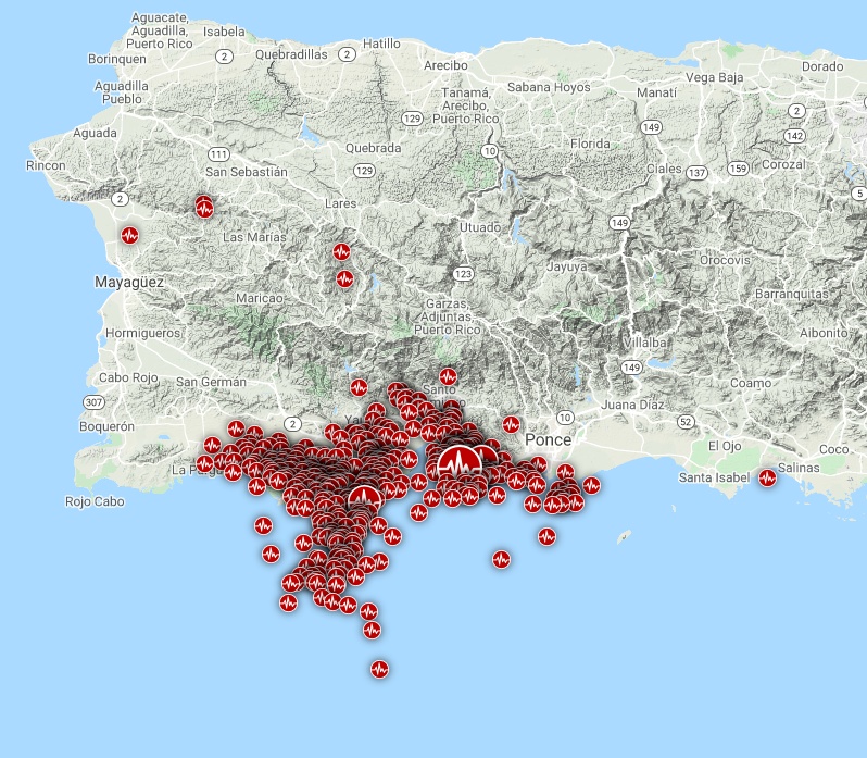
Earthquakes in southern Puerto Rico – May 2020. Credit: TW/SAM, Google. Data source: USGS
USGS said their seismologists were not surprised by the fact that earthquakes occurred but by where they occurred.
Puerto Rico lies on an active boundary between the Caribbean and North American plates, with the northeast corner of the Caribbean plate moving eastward about two centimeters (less than an inch) per year along a strike-slip fault. There is geologic evidence of earthquakes that probably took place millennia ago, while history records earthquakes and tsunamis in Puerto Rico as far back as the 1500s. But most seismic activity has been on the north side of the island, not the south side, where previously unknown undersea faults may have triggered this latest earthquake series.
"It seemed likely that a previously unknown fault system off the south coast was involved in the earthquake sequence, and there should be evidence of that on the seafloor," said Uri ten Brink, a USGS research geophysicist.
"We thought that if that were true, the information would be potentially very valuable to science, and to the people of southern Puerto Rico. They are still recovering from the effects of Hurricane Maria, and now they are facing a completely different type of hazard, and they are hungry for information about it."
Ten Brink, along with scientists from the University of Puerto Rico Mayaguez, ran a sequence of one-day research cruises out of the University of Puerto Rico Marine Station in La Parguera from March 7 to 13.
Preliminary findings confirm ten Brink's assumptions that there is proof of at least one underwater fault in Guayanilla Bay, which might be an extension of a fault mapped previously on land.
Several more faults had been tentatively identified lying 7 and 15 km (4 and 9 miles) offshore, in waters up to about 1 000 m (3 300 feet) deep, also within areas identified as the epicenters of some of the latest earthquakes.
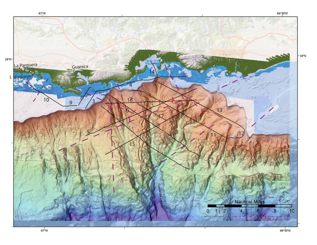
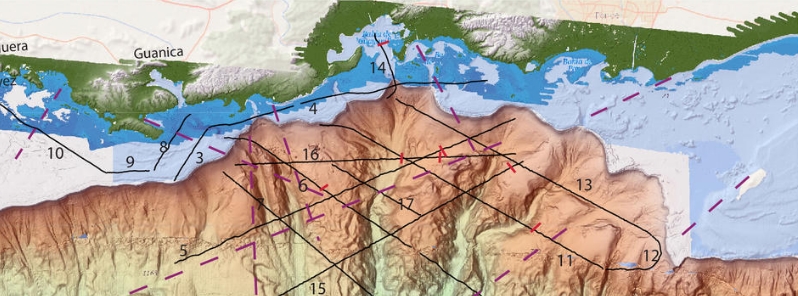
Locations of multichannel seismic reflection profiles (in black), collected during cruise FA2020-14. Image credit: Uri ten Brink, USGS
The team towed a device called "sparker" to map the faults, which uses an electrical charge to produce an air bubble in the sea. When the bubble expands, it generates a sound wave that travels through water and into the seabed, where geologic layers reflect some of the energy back to the surface. The research vessel also towed an array of 32 hydrophones below the sea surface to spot pressure changes underwater.
By measuring differences in the signals' return, researchers can identify differences in the elevation of the rock beneath the seafloor. The differences, called offsets, are considered to be indications of faults that have been active recently.
The USGS team collected about 250 km (155 miles) of seismic reflection data, imaging the seabed and underwater structures at resolutions of just a few meters.
From the ship, several fresh scars were identified in shore-facing cliffs from Punta Montalva to Guayanilla Bay, which was caused likely by rockfalls due to the powerful tremors.
The team also searched for evidence of a fault breaking the seafloor at Punta Montalva, but the seismic data do not indicate clearly such a fault at first look.
Ten Brink said that in the following months, more sophisticated data processing is likely to unveil more faults, and the team expects to be able to measure ruptures along the faults.
"This data will eventually help seismologists develop a clearer picture of tectonic activity in the area," he remarked. "Ultimately, we hope the USGS’ work in this region will help give the public a clearer sense of the potential for future earthquakes."
"The USGS’ research findings are being used to improve building codes that will help Puerto Rico better withstand future earthquakes and to better prepare for tsunamis."
Featured image credit: Uri ten Brink, USGS
Commenting rules and guidelines
We value the thoughts and opinions of our readers and welcome healthy discussions on our website. In order to maintain a respectful and positive community, we ask that all commenters follow these rules:
We reserve the right to remove any comments that violate these rules. By commenting on our website, you agree to abide by these guidelines. Thank you for helping to create a positive and welcoming environment for all.