Bomb cyclone spawns severe blizzard in Iceland, on course to hit Britain
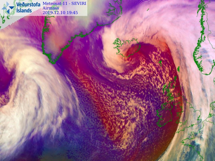
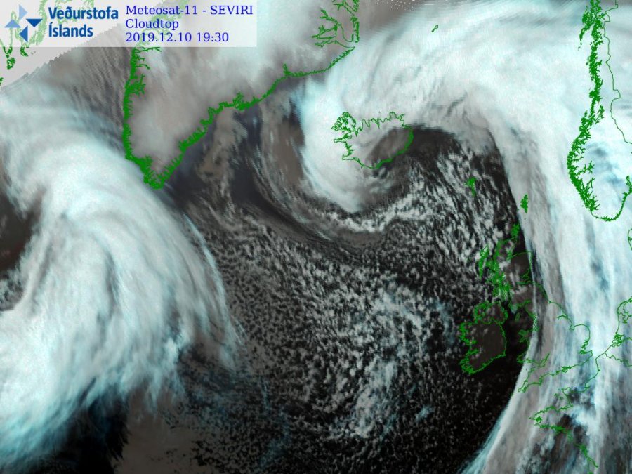
A bomb cyclone accompanied by heavy snowfall and hurricane-force winds hit Iceland on Tuesday, December 10, 2019. The storm hit west of the country first, then it moved to the east on Wednesday, December 11. As a result of strong winds and snow, several cities faced power outages and roads were left paralyzed. It is set to batter Britain in the following days, according to Met Office.
The Icelandic Road and Coastal Administration (IRCA) said nearly all connecting roads across the country remain closed. An avalanche warning was issued for the Westfjords, a region that is already vulnerable to such events.
Rescue workers answered to roughly 600 emergency-related calls, most of them from people dealing with power outages or securing boats in harbors.
The cyclone hit Northeast Iceland hard, resulting in widespread power outages. Roofs were torn and trees were uprooted. Moreover, there had been repeated disruptions in mobile phone coverage across the area.
No severe injuries have been reported so far.
WOW!!! Absolutely incredible but extremely dangerous views of the blizzard in northern #Iceland, this was filmed yesterday evening 10th December! Video via Travel Iceland FB #severeweather #snowstorm pic.twitter.com/ZcQyFmoZxB
— WEATHER/ METEO WORLD (@StormchaserUKEU) December 11, 2019
Severe #Blizzard conditions in Akureyri, Iceland this morning 11th December! Video by Tomáš Popel Popelka thanks for sending this to us. #severeweather #snowstorm pic.twitter.com/4RpdkJV5nZ
— WEATHER/ METEO WORLD (@StormchaserUKEU) December 11, 2019
WOW…. #snowfall accumulation in Akureyri, #Iceland this morning 11th December! Photo sent to us by Stella Arnadottir, thanks! #severeweather #snowstorm pic.twitter.com/cZmvBweAWn
— WEATHER/ METEO WORLD (@StormchaserUKEU) December 11, 2019
This is @OrBragi trying you find his doors and windows in Holmavik, Iceland after the severe snow storm this afternoon 11th December! Epic video thanks @OrBragi 😀 #blizzard #SnowStorm pic.twitter.com/11vnxnri1R
— WEATHER/ METEO WORLD (@StormchaserUKEU) December 11, 2019
Clean up after the severe #blizzard In Akureyri, Iceland yesterday evening 11th December! Video sent in by Radu Ondryášová #severeweather #snowstorm pic.twitter.com/l0MVGvacPV
— WEATHER/ METEO WORLD (@StormchaserUKEU) December 12, 2019
Deep winter scenes In Akureyri, Iceland this evening 11th December! Photos by Helgi Steinar Halldórsson and Athina Travel and good reporter IG #severeweather #blizzard #snowstorm pic.twitter.com/gOej3NJCXs
— WEATHER/ METEO WORLD (@StormchaserUKEU) December 11, 2019
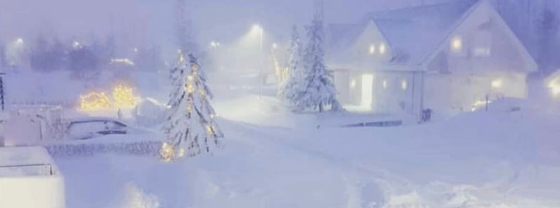
Severe winter conditions from Akureyri, #Iceland this evening 11th December! More snow showers are expected! Report via @ Canerinhavasi IG #severeweather #ExtremeWeather #blizzard pic.twitter.com/cdSTT1nxVG
— WEATHER/ METEO WORLD (@StormchaserUKEU) December 11, 2019
WOW!!! Good morning Akureyri, #Iceland 11th December! Some very large drifts due to the wind strength. Video via Snapchat; #severeweather #ExtremeWeather pic.twitter.com/eT0cdRYzbk
— WEATHER/ METEO WORLD (@StormchaserUKEU) December 11, 2019
Met Office's forecast on Thursday, December 12 said there will be lighter winds and lesser snow showers in Iceland on Friday, December 13.
"However, system 'A' could bring severe gales to south England Friday night. Snow could accompany system 'B' as it moves east across central Britain Saturday night, with gales on its southern side."
There's uncertainty in the track & timing of weather systems over the next few days. However, system 'A' could bring severe gales to S England Friday night. Snow could accompany system 'B' as it moves east across central Britain Saturday night, with gales on its southern side pic.twitter.com/tMMjKtH8eZ
— Met Office (@metoffice) December 12, 2019
It's nearly the weekend, thinking about how the weather might play out?
Here's Clare with all the detail you need, brought to you by Halls @Halls_UKI pic.twitter.com/mFoPIUrHWO
— Met Office (@metoffice) December 12, 2019
Featured image credit: @Canerinhavasi/Instagram
During this same time frame I noticed several days where the entire nations of Spain and France were covered by heavy cloud formations. It was striking due to the size of the region being covered. There are still large remnants of that storm hanging around, … https://earth.nullschool.net/#current/wind/surface/level/overlay=total_cloud_water/orthographic=4.37,49.71,672/loc=-129.443,42.984