Satellite-based radar maps fault of rare earthquake in France

Southeast France was hit by a M5.4 earthquake at 10:52 UTC on November 11, damaging establishments and displacing residents. The tremors were felt between Lyon and Mintellimar.
Earthquakes in this part of France are very rare, prompting scientists to investigate the region.
They turned to satellite-based radar observations to further understand the nature of the seismic fault and map its location. By combining imagery taken before and after an earthquake, shiftings on the ground that happened between two acquisition dates resulted in rainbow-colored interference patterns in the combined image, known as an "interferogram". This enabled scientists to measure ground movement.
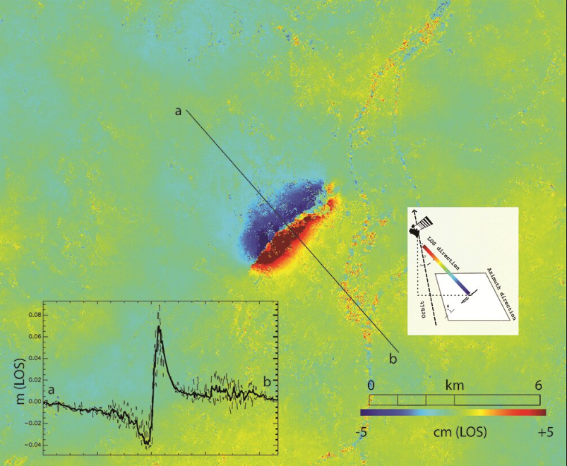
Image credit: modified Copernicus Sentinel data (2019), processed by BRGM
The acquisition was made on November 12 by Copernicus Sentinel-1, a day after the event. It was ready to process on European Space Agency's (ESA) Geohazards Exploitation Platform (GEP) – a cloud-based processing environment with on-demand terrain motion mapping features.
Some users have quantified interferograms over the affected region. While a few faults are present in the region and marked in geological maps, none were identified as seismically active.
The interferogram displayed a series of fringes in the area west of Le Teil city and has enabled scientists to determine the fault at the quake's origin.
Satellite observation also calculated a ground displacement that corresponds to an uplift of up to 80 mm (3 inches) in the southern part of the fault.
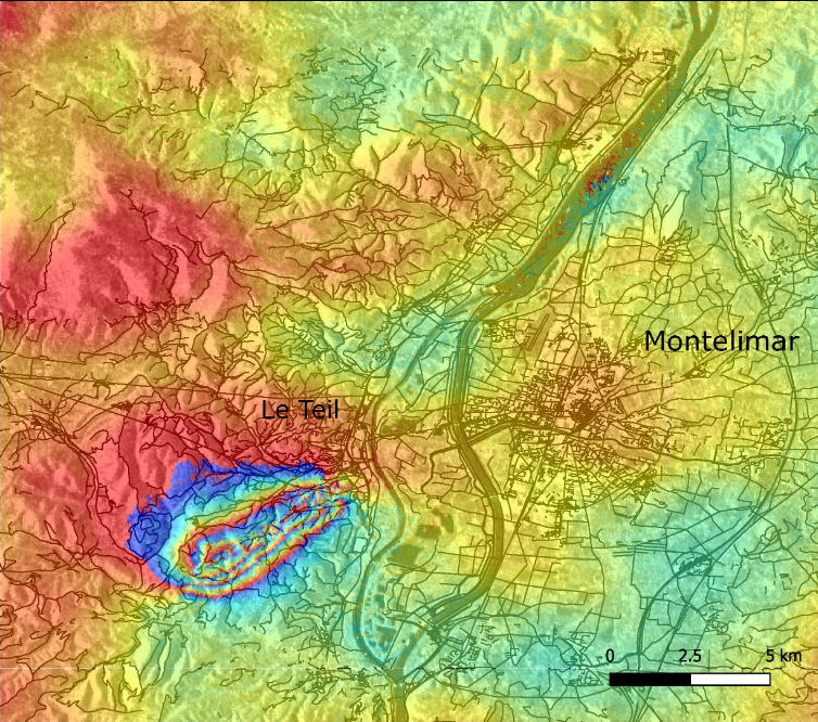
Image credit: modified Copernicus Sentinel data (2019), processed by BRGM
The ground motion's intensity is unusual for this magnitude unless the quake epicenter is shallow. Indeed, seismic data put the epicenter between 1 and 3.5 km (0.6 to 2.2 miles) below the surface.
Observations on November 13 suggested that the rupture generated up to the surface.
"The rapid release to the public of up-to-date Copernicus Sentinel-1 based products visualized in a friendly fashion on the GEP geobrowser was followed by a peak of connections. It helped the scientific community better map the location of the fault and to confirm the mechanism of the earthquake," said ESA researcher, Floriane Provost.
"This example shows how the GEP environment contributes to the rapid processing and exchange of information within the geohazards community."
"Field investigations by BRGM experts are on-going, while interferometric synthetic aperture radar results are actually helping them to correlate the distribution of damage with the location of the activated fault and measured ground displacements," added Michael Foumelis, a researcher at the French Geological Survey BRGM.
Featured image credit: ESA/ATG medialab
Excellent work by ESA and GEP making the data publicly available – promoting citizen science as well as widening academic inclusion. If only all such data sets were as readily available. Textbook style normal fault profile, showing tensional (extensional) tectonic regime. The data is so accurate, it even shows the difference in ‘height’ (depth) of the changing water level in the local rivers!
Thanks for the e-quake news… yaaah69