Tropical Cyclone “Matmo” (Bulbul) makes landfall over Indo-Bangladesh coast
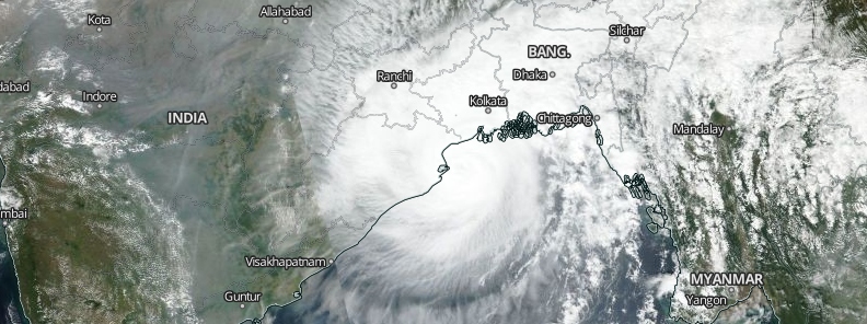
Authorities have ordered evacuation for around 500 000 people from the low-lying coastal villages and islands of Bangladesh in preparation for Tropical Cyclone "Matmo," renamed Bulbul by the India Meteorological Department (IMD). The cyclone made landfall Saturday night, November 9, 2019, over Indo-Bangladesh coast as Severe Cyclonic Storm. It crossed the coast abeam Sagar Islands with winds up to 120 km/h (75 mph) and gusts up to 130 km/h (81 mph).
IMD has asked local authorities and two ports to raise their highest alert as the storm is expected to spawn a storm surge as high as 2 m (7 feet) in coastal districts, with a maximum wind speed of 120 km/h (75 mph). Flooding, heavy rain, and damaging winds are all threats through Sunday, November 10.

Tropical Cyclone "Matmo" on November 9, 2019. Credit: NASA/NOAA Suomi NPP / VIIRS
Matmo, currently the equivalent of a Category 1 cyclone, is centered 88 km (55 miles) South Southeast of the coastal town of Digha, moving north at 16 km/h (10 mph). The cyclone is set to make landfall somewhere along the Bay of Bengal coast of eastern India by Saturday night.
As of 18:21 LT, Matmo's present intensity is 125 to 135 km/h (78 to 84 mph), gusting to 150 km/h (93 mph). It is likely to weaken gradually and move northeastwards and cross West Bengal-Bangladesh coasts between Sagar Island and Khepupra.
During the next 6 to 12 hours, places including Digha, Sagar Islands, Midnapore, Kolkata, Hooghly, Howrah 24 South Parganas, Purba Medinipur, and adjoining areas would see very heavy rains.
#Cyclone #Bulbul is likely to move northeastwards while weakening gradually, and cross #WestBengal – Bangladesh Coast between Sagar Islands and Khepupara (Bangladesh), across Sunderban delta by late evening or night today. #CycloneBulbul https://t.co/LU9Escv2ba
— SkymetWeather (@SkymetWeather) November 9, 2019
Rainfall totals of 76 to 254 mm (3 to 10 inches) with locally higher amounts are expected over West Bengal state into parts of southwest and central Bangladesh, possibly as far north as the megacities of Kolkata and Dhaka. Significant damage to homes, electric lines, trees, and crops is also forecasted.
According to disaster management secretary Shah Kamal, there are plans to displace around 1.5 million people before Matmo is expected to hit the Bangladesh coast at around 20:00 LT.
Authorities have already suspended a nationwide school test, canceled holidays of officials in coastal districts, and canceled a traditional fair that would be attended by around 10 000 people in the Sundarbans. Moreover, operations at Mongla and Chittagong, the nation's two major ports, have also been suspended.
Around 55 000 volunteers have been deployed to go door-to-door and warn people of the storm.
Cyclone ‘Bulbul’: Naval Ships and Aircraft Standby for Rescue and Relief Ops. Naval Aircraft deployed in the Bay of Bengal have been warning fishing boats about the impinging cyclone and advising them to return to the nearest harbour for shelter.#CycloneBulbul pic.twitter.com/80ssK3yydL
— Doordarshan News (@DDNewsLive) November 9, 2019
Strong cyclones commonly pound the country's low-lying coast, which is home to 30 million people. The storms usually leave a trail of devastation in their wake. Over the past few decades, hundreds of thousands of residents have died in such calamity. Fortunately, Bangladesh has improved its disaster preparedness, lowering the number of fatalities since 2007 Cyclone Sidr, which killed over 3 000.
Early cyclone warning systems have also improved, giving authorities more time to alert and displace residents. Shelters have been built over the past years, and officials have ordered school buildings and mosques to be used as a refuge in addition.
In May 2019, Tropical Cyclone "Fani," the most powerful storm to hit the country in five years, struck the area and killed over a dozen people.
Update:
Radar shows #Cyclone #BULBUL (formerly #MATMO in WPAC) making landfall in the Ganges delta region of #WestBengal #India—just S of #Kolkata. Estimated winds are 85 knots. This part of India & neighboring #Bangladesh are prone to extensive storm-surge flooding. pic.twitter.com/ZKzZtJoG2H
— Josh Morgerman (@iCyclone) November 9, 2019
Matmo made landfall over Indo-Bangladesh coast as Severe Cyclonic Storm, crossing the coast abeam Sagar Islands with heavy rain and winds up to 120 km/h (75 mph), gusting up to 130 km/h (81 mph).
"The next 6 to 8 hours continue to be crucial for West Bengal as Bulbul would take another six hours to weaken into Cyclonic Storm after crossing the coast," Skymet Weather meteorologists said.
"Thus, the next 12 hours will be crucial. Storm surge will be from 2.5 to 3 m (8 to 10 feet) which would lead to inundation in the low lying areas. Lightning strikes are to be watched out for, which may be damaging. Coastal areas of West Bengal inclusive of Digha, Howrah, Hooghly, 24 Parganas, Medinipur are witnessing winds in excess of 100 km/h (62 mph) while Kolkata winds were in excess of 70 – 80 km/h (40 – 50 mph). Moving northeastwards further, it would head for the northeastern states of India as a depression. However, this would be not before Sunday morning."
Featured image credit: NASA/NOAA Suomi NPP / VIIRS
Commenting rules and guidelines
We value the thoughts and opinions of our readers and welcome healthy discussions on our website. In order to maintain a respectful and positive community, we ask that all commenters follow these rules:
We reserve the right to remove any comments that violate these rules. By commenting on our website, you agree to abide by these guidelines. Thank you for helping to create a positive and welcoming environment for all.