Extremely dangerous Typhoon “Hagibis” nears Tokyo, potentially the strongest to hit the city since 1958, Japan
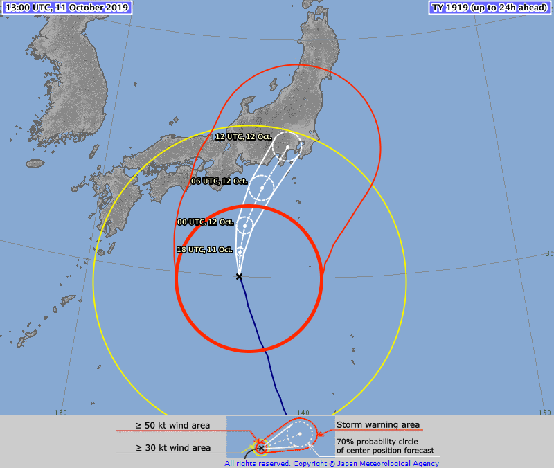
Extremely dangerous Typhoon "Hagibis" is approaching Japan. Landfall is expected near Tokyo on October 12 with maximum sustained winds of 160 km/h (98 mph), equivalent to Category 2 hurricane on the Saffir-Simpson Hurricane Wind Scale. Authorities are urging residents and tourists to prepare in advance and protect their lives.
- The Japan Meteorological Agency (JMA) said Hagibis has the potential to bring record-breaking rain and winds.
- Hagibis could be on par with Typhoon "Kanogawa" of 1958 that left hundreds of thousands of homes flooded and more than 1 200 people dead in the Kanto region and Izu archipelago.
- Prolonged power and water outages are expected. Prepare.
"The typhoon may make landfall in the Tokai or Kanto region on Saturday, and remain extremely strong. In addition to storm winds and high waves, we're looking at the possibility of record rainfall around the Kanto region," JMA's forecast chief Yasushi Kajihara said. "To protect your own life and your loved ones, please try to start evacuating early before it gets dark and the storm becomes powerful."
Heavy to record-breaking rain is expected in wide parts of Honshu, especially in Tokai and Kanto. Wind speeds may reach up to 162 km/h (100 mph) in Tokai and 144 km/h (90 mph) in Kanto-Koshin. Maximum gusts of 216 km/h (134 mph) may hit both regions.
Waves may reach 13 m (42 feet) off Tokai, Kanto and the Izu Islands, and 10 m (33 feet) off Tohoku and Kinki regions. Storm surges are expected in eastern Japan and the Kinki region between Saturday afternoon and evening.
Weather officials are urging people to keep track of the latest weather bulletins and local evacuation advisories and to flee to safety before conditions deteriorate, NHK reports.
More than 900 flights have already been canceled. Rail operators warned they expect major disruptions over the weekend, too.
The Rugby World Cup held in Tokyo and other events and tourist attractions, including Tokyo Disneyland and Tokyo DisneySea, have been canceled.
Shigeo Kannaka, a director of Japan Bosai (Disaster Prevention) Society, urged caution against the prolonged power and water outages.
He recommended filling bathtubs, kettles and buckets with water that can later be used to flush toilets and fulfill other domestic purposes. Flashlights, lanterns and portable radios will also come in handy in the event of a power failure, he said.
Other safety precautions, he said, include taping windows in all directions to prevent them from fragmenting when they break, stocking up on enough potable water for three days, and topping up the gas tanks of cars and other vehicles.
Residents are also advised to charge their smartphone batteries, secure laundry poles and empty fridges of perishable food that could spoil in a power outage.
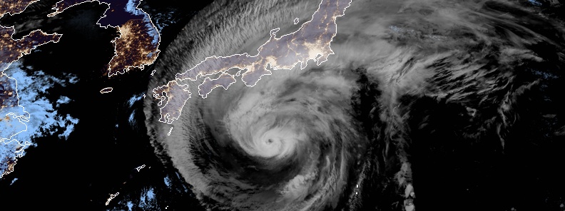
At 06:00 UTC on October 11, the center of Typhoon "Hagibis" was located about 650 km (405 miles) southeast of Kochi, 665 km south of Hamamatsu, and 790 km/h (490 miles) south-southwest of Tokyo, Japan.
Its maximum 10-minute sustained winds were 175 km/h (110 mph), gusting to 250 km/h (155 mph), while maximum one-minute sustained winds are at 215 km/h (130 mph). The central barometric pressure was 925 hPa, and the system was moving north-northwestwards at 25 km/h (16 mph).
Hagibis will hit the same region as the devastating Typhoon "Faxai" just one month ago. Faxai destroyed approximately 30 000 homes, left nearly 1 million without power, killed 2 and injured more than 40.
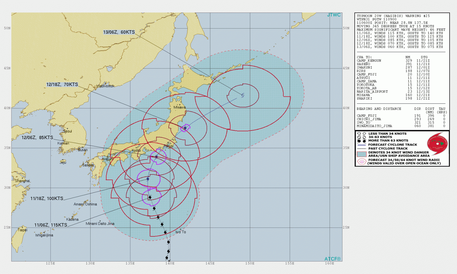
According to Philip Klotzbach, a meteorologist at the Colorado State University, Hagibis underwent the strongest quick intensification of any tropical cyclone from the western Pacific in at least 23 years.
1983 Super Typhoon "Forest" had winds intensifying from 121 km/h (75 mph) Category 1 to 282 km/h (175 mph) Category 5 in a period of 24 hours. Hagibis' rapid intensification is equivalent to nearly three and a half times the rate a storm would require to strengthen.
During the height of its intense strengthening, Hagibis became a major hurricane-level typhoon in just six hours.
Only a few previous hurricanes topped Hagibis' shocking intensification rate.
2015 Hurricane "Patricia" had increased winds from 137 km/h (85 mph) to 193 km/h (120 mph) in 24 hours, which became the most powerful hurricane on record in the Western Hemisphere with maximum winds up to 346 km/h (215 mph). Hagibis' rate is comparable to that of Patricia.
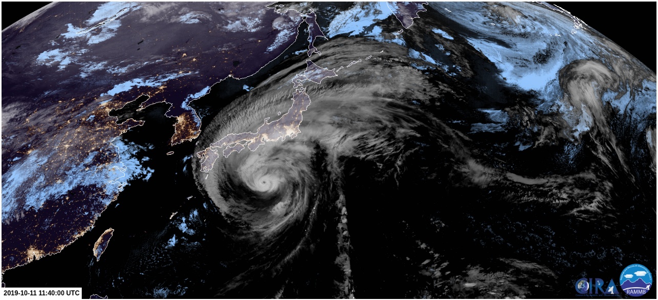
Featured image: Typhoon "Hagibis" at 11:40 UTC on October 11, 2019. Credit: JMA/Himawari-8
Merl, a large object from space causing a tidal wave hid by the storm? Is that about right?
Elisabeth, As MOST scientists (both bought and not bought) already know and have known since 1998, it’s the Earths north and south magnetic poles which are shifting (hint: our Sun plays a big part) that causes an increase in temperatures (BOTH cold & warm), storms, earthquakes, volcanic eruptions, etc, not some fairy tale of a man-made climate nonsense made up to brainwash and control the masses, and in which you have admittedly have become victim to.
It’s not the sun. It’s the heating up of the ocean, caused by your oil-interests. We don’t take such silly jokes anymore.
L’observation d’un nuage sombre au large des côtes japonaises au-dessous duquel se forment des tornades, 5 jours avant la date à laquelle un typhon est censé se produire, laisse penser que la tempête attendait le bon moment au large pour être dirigée vers le Japon, afin de le plus probable, couvrez une onde de marée qui serait créée par un objet plus grand venant de l’espace.
THE SHIFTING OF THE SOLAR SYSTEM INTO A DENSER REGION IN SPACE
Typhoons and hurricanes are getting stronger and the increase of cosmic-solar radiations is the cause. In addition to the increase of Cosmic-Solar radiations, interplanetary space has become more conductive. And the increase in the conductivity of the interplanetary space is obvious from the speed of the solar wind. Coronal Mass Ejections are now traveling faster and faster. In physical reality, our solar system has shifted into a denser energy region and this is the reason for the changes that are taking place in our star and on our planet. https://www.thegwpf.com/cosmic-rays-are-nearing-a-space-age-record/