Alert Level 1 raised over Taal volcano, Philippines
The Philippine Institute of Volcanology and Seismology (PHIVOLCS) raised Alert Level 1 over the Taal volcano after recording 87 volcanic earthquakes within a 24-hour observation period ending 00:00 UTC, October 7. One of the quakes, which occurred at 07:54 LT, was felt at Intensity 1 at Tibag and Alas-as, the northern and southwestern sectors of the island. The agency also reported an increase in water temperature from 32.6 °C (90.68 °F) to 33 °C (91.4 °F) during field measurements on October 3 at the western sector of the Main Crater Lake.
Meanwhile, the water level remained at 0.49 m (19 inches), and the acidity dropped from a pH of 2.82 to 2.83. Ground deformation measurements through accurate leveling surveys from September 19 to September 26 showed inflation of the edifice consistent with the latest results from continuous GPS data.
Alert Level 1 indicates that a hazardous eruption is not imminent, but the main crater remains closed to the public.
The agency said steam explosions may occur, along with possible accumulations of high concentrations of toxic gases. Furthermore, the northern portion of the Main Crater rim in the area of the Daang Kastila trail may also become dangerous, particularly if the steam emission along existing fissures suddenly rises.
PHIVOLCS warned the public that the entire Volcano Island is a permanent danger zone (PDZ), and permanent settlement in the area is prohibited.
Taal Volcano's last major eruption occurred on October 2, 1977.
Geological summary
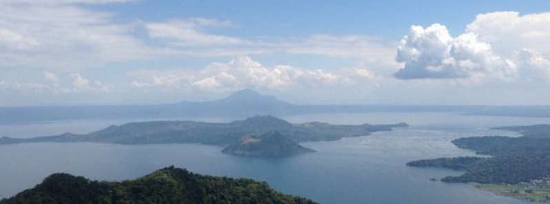
Taal is one of the most active volcanoes in the Philippines and has produced some of its most powerful historical eruptions. Though not topographically prominent, its prehistorical eruptions have greatly changed the topography of SW Luzon. The 15 x 20 km (9 x 12 feet) Talisay (Taal) caldera is largely filled by Lake Taal, whose 267 km2 (103 mi2) surface lies only 3 m (9.8 feet) above sea level.
The maximum depth of the lake is 160 m (525 feet), and several eruptive centers lie submerged beneath the lake. The 5-km-wide (3.1 miles) Volcano Island in north-central Lake Taal is the location of all historical eruptions. The island is composed of coalescing small stratovolcanoes, tuff rings, and scoria cones that have grown about 25% in the area during historical time. Powerful pyroclastic flows and surges from historical eruptions have caused many fatalities.
Featured image credit: Chris Newhall, USGS
Commenting rules and guidelines
We value the thoughts and opinions of our readers and welcome healthy discussions on our website. In order to maintain a respectful and positive community, we ask that all commenters follow these rules:
We reserve the right to remove any comments that violate these rules. By commenting on our website, you agree to abide by these guidelines. Thank you for helping to create a positive and welcoming environment for all.