Strong tremor signal at Semisopochnoi volcano, Aviation Color Code raised to Orange, Alaska
Elevated seismicity that began under Semisopochnoi volcano, Alaska on July 17, 2019, increased overnight and was followed by a stronger tremor signal recorded at 07:39 UTC, July 18.
In addition, an infrasound signal was produced on an infrasound array located 260 km (161 miles) east on Adak island.
This event likely produced ash emissions, and at the current level of continued unrest similar events could occur with little to no warning, the Alaska Volcano Observatory reports.
The meteorological cloud deck has been around 3 000 m (10 000 feet) above sea level over Semisopochnoi and no ash signals have been detected above this height.
A small plume extending 18 km (11 miles) from the Cerberus vent was visible in satellite data from yesterday but did not contain an ash signal.
Nothing has been detected in lightning data.
As a result, AVO has raised to Aviation Color Code from Yellow to Orange and Volcano Alert Level from Advisory to Watch at 18:38 UTC.
Geological summary
Semisopochnoi, the largest subaerial volcano of the western Aleutians, is 20 km (12.4 miles) wide at sea level and contains an 8-km-wide (5 miles) caldera. It formed as a result of collapse of a low-angle, dominantly basaltic volcano following the eruption of a large volume of dacitic pumice. The high point of the island is 1221-m-high (4 005 feet) Anvil Peak, a double-peaked late-Pleistocene cone that forms much of the island's northern part.
The three-peaked 774-m-high (2 539 feet) Mount Cerberus volcano was constructed during the Holocene within the caldera. Each of the peaks contains a summit crater; lava flows on the northern flank of Cerberus appear younger than those on the southern side.
Other post-caldera volcanoes include the symmetrical 855-m-high (2 903 feet) Sugarloaf Peak SSE of the caldera and Lakeshore Cone, a small cinder cone at the edge of Fenner Lake in the NE part of the caldera.
Most documented historical eruptions have originated from Cerberus, although Coats (1950) considered that both Sugarloaf and Lakeshore Cone within the caldera could have been active during historical time.
This volcano is located within the Aleutian Islands, a UNESCO Biosphere Reserve property.
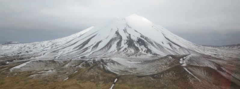
Featured image: Mt Cerberus from the east. Photos of Semisopochnoi Island taken in May 2017 during AVO station maintenance activities and supported by U.S. Coast Guard. Credit: Max Kaufman
Commenting rules and guidelines
We value the thoughts and opinions of our readers and welcome healthy discussions on our website. In order to maintain a respectful and positive community, we ask that all commenters follow these rules.