Flash Flood Emergency in New Orleans, Mississippi River projected to see one of its highest crests on record
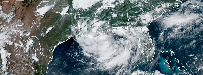
A Flash Flood Emergency was declared for New Orleans, Louisiana early Wednesday morning, July 10, 2019, after up to 254 mm (10 inches) of rain hit the city within just several hours.
The rain was produced by a tropical disturbance organizing in the Gulf of Mexico and expected to become a tropical storm (Barry) on July 11 and a hurricane on the 12th.
Bourbon Street is flooded #NewOrleans https://t.co/enXI6uwyn4 pic.twitter.com/1YHQAcEfqA
— Greg Diamond (@gdimeweather) July 10, 2019
#NewOrleans has received 4 to 5 inches of rain over the last 24 hours, with reports of flash flooding throughout the city, including the #FrenchQuarter. This comes as @NOAA reported the wettest 12-month period on record in the U.S. dating back 125 years. pic.twitter.com/NDSvbFpvCO
— Pattrn (@pattrn) July 10, 2019
WOW!!!! Now that’s a photogenic #WaterSpout this morning off #NewOrleans, USA! Brilliant view too. #tornado https://t.co/IZE1VeQqpy
— WEATHER/ METEO WORLD (@StormchaserUKEU) July 10, 2019
Waterspouts, flash flood emergencies, what a wild start to Wednesday in New Orleans! Meteorologist @GarofaloWX shows us how much rain came down and some of the sights around the city. #neworleans #lawx pic.twitter.com/twi2HSzLiQ
— WeatherNation (@WeatherNation) July 10, 2019
The system is expected to produce total additional rain accumulations of 152 – 304 mm (6 to 12 inches) near and inland of the central Gulf Coast through early next week, with isolated maximum rainfall amounts of 458 mm (18 inches), NHC noted.
NWS extended the Storm Surge Watch westward to Intracoastal City Louisiana at 21:00 UTC today. A Hurricane Watch has been issued from the Mouth of the Mississippi River westward to Cameron Louisiana and a Tropical Storm Watch has been issued from north of the Mouth of the Mississippi River to the Mouth of the Pearl River.
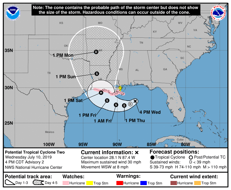
The Mississipi River at New Orleans is already at 4.87 m (16 feet) due to historic spring flooding in the central U.S. This is just 30 cm (1 foot) below flood stage.
However, the projected surge of 90 – 1.5 cm (3 to 5 feet) would raise the level to 5.8 – 6.7 m (19 – 22 feet); this is above minor flood stage of 19 feet and major – 6 m (20 feet).
The record level for this area is 6.49 m (21.3 feet) set in 1922.
Featured image credit: NOAA/GOES-East. Acquired: 20:50 UTC, July 10, 2019
Commenting rules and guidelines
We value the thoughts and opinions of our readers and welcome healthy discussions on our website. In order to maintain a respectful and positive community, we ask that all commenters follow these rules.