Mount Shindake erupts, large pyroclastic flow produced, Japan
Mount Shindake on Japanese Kuchinoerabujima island erupted at 00:19 UTC (09:19 JST) on January 17, 2019, ejecting ash up to 6 km (19 600 feet) above sea level. The volcano is sporadically erupting since October 2018. The Alert Level remains at 3 (of 5).
The eruption rattled buildings and produced a pyroclastic flow that traveled about 1.5 km (0.92 miles) to the southwest and northwest of the crater. There are no reports of damage or injuries and the flow did not reach any communities or the coast.
"There have been eruptions there since last year but we sent an alert out for this latest eruption as it will have a wider impact," said Jun Fujimatsu, an official at JMA's volcanic activity division.
"The agency maintains level three warning, which means a ban on entering the volcano area. The danger zone is 2 km (1.2 miles) from the Shindake crater," Fujimatsu told AFP.
There are no evacuations at the island at this time but officials are preparing in case it becomes necessary.
Significant explosive eruption just now at the restless Kuchinoerabu #volcano in #Japan images via JMA webcam. H/t @wataruen pic.twitter.com/m1nr3bp3VT
— James Reynolds (@EarthUncutTV) January 17, 2019
口永良部島の火山活動解説資料/気象庁(H31.1.17)https://t.co/AHR7vbwDoO
「火砕流が火口から南西側及び北西側へ約1,500m流下」 pic.twitter.com/mrMsEcxlg7— 上川瀬名 (@Yokohama_Geo) January 17, 2019
口永良部島監視カメラ(本村西)/気象庁
Kuchinoerabu Jan.17 9:18-9:20-9:22 pic.twitter.com/QDSUn8q3Qi— 上川瀬名 (@Yokohama_Geo) January 17, 2019
報道各社様、今日はほぼ飛行機にのりっぱなしなのでDMする余裕がありません。
画像動画はご自由にお使いください。 pic.twitter.com/dbCRUfaA48— Skylake (@Skylake_11293) January 17, 2019
A strong eruption of this volcano took place at 07:37 UTC on December 18, 2018. Volcanic ash rose up to 2 000 m (6 500 feet) above the crater (2 640 m / 8 656 feet a.s.l.), large rocks were seen spewing from the crater, and pyroclastic flow, the first since May 2015, reached a distance of about 1 km (0.62 miles) down the western slope.
Shindake's last major eruption took place in 2015 (VEI 5) when pyroclastic flows reached the coast and forced all residents to evacuate.
At this time, there are about 100 people living on the island.
Geological summary
A group of young stratovolcanoes forms the eastern end of the irregularly shaped island of Kuchinoerabujima in the northern Ryukyu Islands, 15 km (9.3 miles) west of Yakushima. The Furudake, Shindake, and Noikeyama cones were erupted from south to north, respectively, forming a composite cone with multiple craters.
The youngest cone, centrally-located Shintake, formed after the NW side of Furutake was breached by an explosion. All historical eruptions have occurred from Shintake, although a lava flow from the S flank of Furutake that reached the coast has a very fresh morphology.
Frequent explosive eruptions have taken place from Shintake since 1840; the largest of these was in December 1933. Several villages on the 4 x 12 km (2.5 x 7.5 miles) island are located within a few kilometers of the active crater and have suffered damage from eruptions.
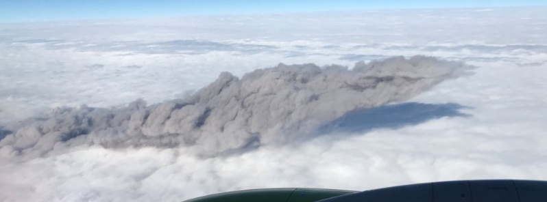
Featured image: Mount Shindake eruption on January 17, 2019. Credit: Skylake
Edit: first date in article says Jan 2018…
THANK YOU! <3