Major Sudden Stratospheric Warming (SSW) underway, significant winter weather likely across large parts of Europe
A major Sudden Stratospheric Warming (SSW) event is currently underway in the stratosphere above the Arctic. While not every SSW event is the same and it takes some time for it to show its effects in the troposphere, meteorologists say we can expect colder air move into Europe in the next 15 – 20 days, with proper winter weather likely and even snow in eastern and central Europe, that could continue into February.
The current SSW process has begun around a week ago and is now slowly progressing from the stratosphere down into the troposphere, the lowest layer of Earth's atmosphere.
"A SSW event usually has the strongest impact over the north pole. Higher pressure can be expected to build over and around the Arctic region, which enables colder arctic airmass to advect far south into the mid-latitudes. Currently, GEFS is simulating a more classic SSW-response, by creating this higher pressure over the Arctic region and bringing colder airmass into Europe and eastern parts of North America," SWE meteorologists said.
Although sudden stratospheric warmings are mainly forced by planetary-scale waves which propagate up from the lower atmosphere, there is also a subsequent return effect of sudden stratospheric warmings on surface weather, the UK Met Office said early 2018 when we witnessed the last SSW event.
"Following a sudden stratospheric warming, the high altitude winds reverse to flow westward instead of their usual eastward. The westward winds progress down through the atmosphere and weaken the jet stream, often giving easterly winds near the surface and resulting in dramatic reductions in temperature in Europe. This process can take a few days to a few weeks to occur."
When an SSW brings easterly winds this tends to alter our weather patterns slightly, weakening areas of low pressure and moving our jet stream further south. This leads to high pressure over the North Atlantic, 'blocking' the flow of mild Atlantic air and dragging in cold air from the continent to the east. SSWs don't always result in this outcome – but a cold snap follows more often than not, so the SSW greatly increases the risk of wintry weather.
It gives me great pleasure to announce…
The 10 hPa 60N zonal-mean zonal wind has (finally) become easterly, per the 18Z GFS analysis, indicating a major #SSW is now occurring. pic.twitter.com/l74tH1o5cM— Simon Lee (@SimonLeeWx) January 1, 2019
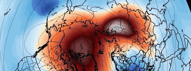
I don't normally tweet GFS 384 hour charts… but this looks like the split #PolarVortex is smiling back at us, right? #SSW
Image via @wxcharts. pic.twitter.com/U4l22LTHNs— Simon Lee (@SimonLeeWx) January 1, 2019
Couldn't ask for a better start to 2019 than a major #SSW split! Happy New Year, everyone! pic.twitter.com/KUGVssaTXf
— Amy H Butler (@DrAHButler) December 31, 2018
Hammarland, W-Finland just recorded 32 m/s as a 10-minute sustained wind speed with 40 m/s gust.
Both are new *all-time* records for Finland.
At the same time, major sudden stratospheric warming occurred.
Welcome 2019, it probably won't be boring weather-wise. pic.twitter.com/stW9Z81eFh
— Mika Rantanen (@mikarantane) January 2, 2019
Featured image credit: wxcharts.eu
Commenting rules and guidelines
We value the thoughts and opinions of our readers and welcome healthy discussions on our website. In order to maintain a respectful and positive community, we ask that all commenters follow these rules:
We reserve the right to remove any comments that violate these rules. By commenting on our website, you agree to abide by these guidelines. Thank you for helping to create a positive and welcoming environment for all.