New eruptions at Anak Krakatau eject ash up to 15 km (50 000 feet) a.s.l., Indonesia
New strong eruptions were reported at Anak Krakatau early January 2, 2019 (UTC) after several days of relative calm. According to the Darwin VAAC, ash plumes were observed rising up to 12 km (40 000 feet) and 15 km (50 000 feet) above sea level.
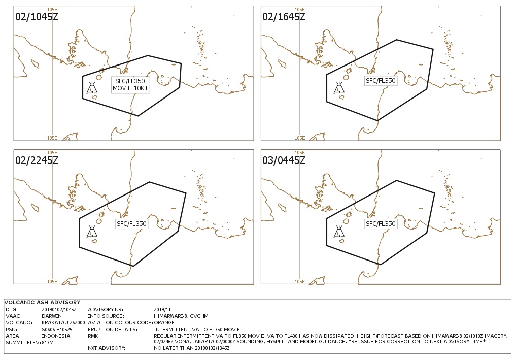
Volcanic ash up to 11.6 km (38 000 feet) a.s.l. is discernible on latest Himawari-8 satellite imagery, extending to the east, the Darwin VAAC reported 00:41 UTC, January 2. At the same time, a secondary plume to 15 km (50 000 feet) a.s.l. is extending to the southwest.
According to the Anak Krakatau Volcano Observatory notice for aviation (VONA) issued 02:46 UTC today, an eruption with ash clouds, lasting 71 seconds, took place at 02:38 UTC (09:38 local time).
The best estimate of the ash-cloud top is around 1 610 m (5 152 feet) a.s.l. but may be higher than what can be observed clearly from the ground, the observatory said. The eruption was recorded on a seismogram as continuous tremor with a maximum amplitude of 11 mm.
Volcanic ash to 11.6 km (38 000 feet) a.s.l. is no longer discernible on latest satellite imagery. However, a new eruption is currently underway, the Darwin VAAC reported 03:37 UTC. Volcanic ash to 15 km (50 000 feet) a.s.l. is moving to the south and is expected to dissipate within 6 hours.
Regular intermittent volcanic ash to 10.6 km (35 000 feet) a.s.l. is moving east. Volcanic ash to 12.2 km (40 000 feet) a.s.l. has now dissipated, the center reported 11:41 UTC.
The Aviation Color Code remains Orange.
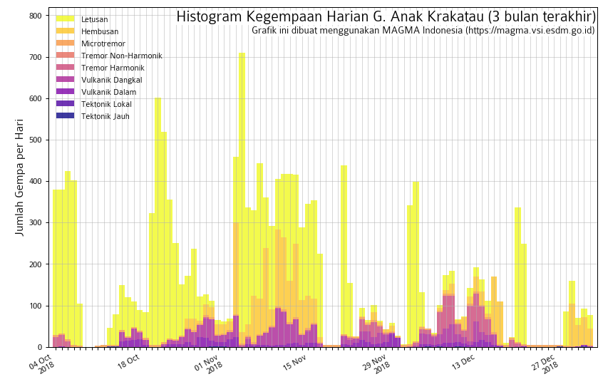
"Seismic activity is still relatively low, but has picked up again after a phase of near absence at the end of 2018," said volcanologist Dr. Tom Pfeiffer.
Great @planetlabs image of #AnakKrakatau on Dec 30. Looks like most of the pre-Dec 22 island is now covered by new tephra, except the NW part. Prominent slick of discolored seawater is prob. due to submarine degassing. @Sutopo_PN @vulkanologi_mbg
Copyright 2018 Planet Labs Inc. pic.twitter.com/dbRdUATYF9
— Simon Carn (@simoncarn) December 31, 2018
A comparison of before and after #Sentinel2 images show the immense change of #AnakKrakatau island morphology. #Landslide flank collapse on the west and new deposits to the east. Yellow is coastline digitized from Nov 16 imagery, red is the latest of Dec 29. pic.twitter.com/re3vzShBqd
— Sotiris Valkaniotis (@SotisValkan) December 29, 2018
sentinel-1 satellity imagery analysed: Apparently clear loss of land at southern flank of #anak #krakatoa #volcano. This lead to the #tsunami #landslide affecting #Banten and #Lampung, #Indonesia (post-image from 22:35 UTC, Dec, 22nd) pic.twitter.com/OV8kBcEaId
— CATnews | Andreas M. Schäfer (@CATnewsDE) December 23, 2018

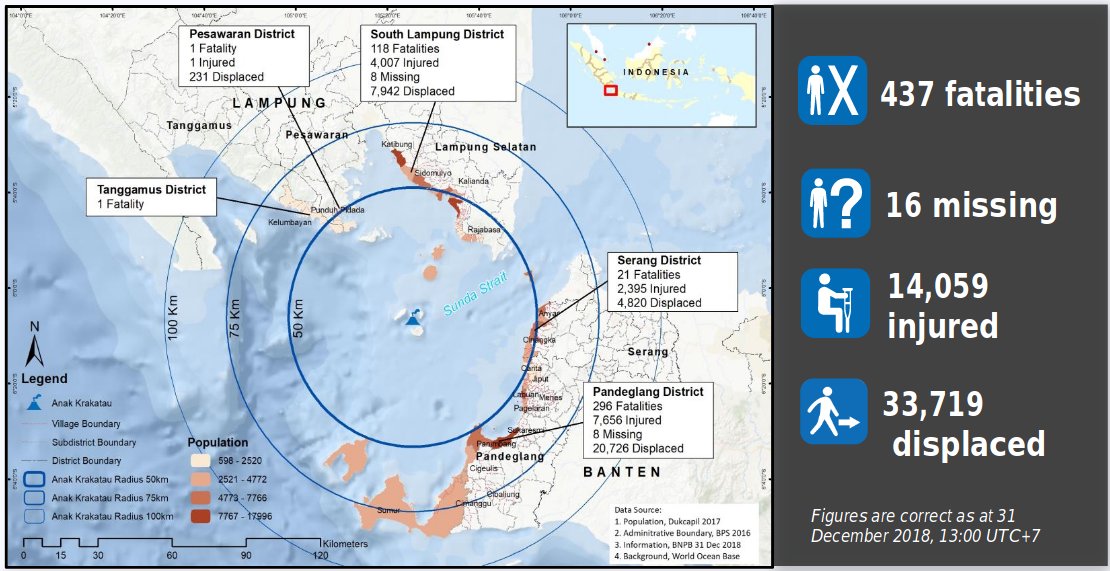
The number of people killed by the December 22, 2018 Sunda Strait tsunami now stands at 437. 14 059 people were injured and 16 are still missing.
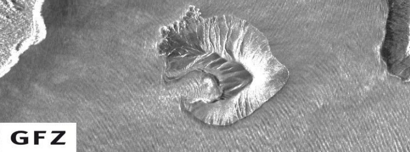
"The island of Anak Krakatau now has the shape of a 270 deg almost closed crescent, with a water-filled crater in the center where once the 330 m (1 062 feet) tall summit cone stood," Pfeiffer said.
"Processed satellite image acquired December 28 shows the change in morphology even clearer but includes a significant land gain after the collapse as well, which seems to have built most of the southern 'arm' of the crescent. Most of the new land is probably due to accumulated material (tephra) from the intense Surtseyan activity in the days after the landslide, building a new large tuff ring around the crater."
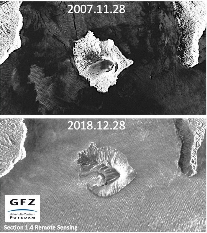
Featured image credit: GFZ Postdam
Commenting rules and guidelines
We value the thoughts and opinions of our readers and welcome healthy discussions on our website. In order to maintain a respectful and positive community, we ask that all commenters follow these rules:
We reserve the right to remove any comments that violate these rules. By commenting on our website, you agree to abide by these guidelines. Thank you for helping to create a positive and welcoming environment for all.