Deadly floods hit Texas after extreme rainfall, state of emergency declared

Central Texas received extreme rainfall over the past couple of days leading to major floods that claimed a life of at least one person and forced authorities to declare a state of emergency for 18. Texas governor urged "all Texans to take their safety into their own hands by closely monitoring changing weather conditions and heeding warnings from local officials." Another round of heavy rain is expected on Thursday and Friday, October 18 and 19. Rainfall and river level records are falling one by one.
Governor Greg Abbott ordered the Texas State Operations Center to elevate its readiness as severe weather and flooding hit Texas Tuesday morning, October 16, 2018.
A school bus was with at least one student inside was swept away 16 after the driver tried to go through a flooded low-water crossing. Both were rescued.
Another incident took place near Andice, where a mother and her child had to be rescued after their vehicle washed off County Road 252.
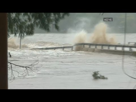
Shortly after, the FM 2900 bridge in Kingsland was closed because of rising floodwaters and evacuations in the region intensified. The bridge collapsed later in the day, and its pieces were seen floating down the river. This region received between 200 and 305 mm (8 and 12 inches) of rain within 48 hours.
Numerous water rescues took place during the rest of the day as river levels continued rising and flood situation became much worse, with numerous roads and homes flooded.
One fatality has been confirmed after a body was found in Burnet County along the Colorado River between Kingsland and Granite Shoals.
Governor Abbott declared a state of emergency in 18 counties: Bastrop, Burnet, Colorado, Fayette, Hood, Jim Wells, Kerr, Kimble, La Salle, Live Oak, Llano, Mason, McMullen, Nueces, Real, San Patricio, Travis, and Williamson.
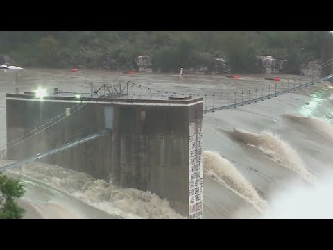
Flood operations at Buchanan Dam began at 22:00 LT. LCRA said it plans to open one floodgate an hour for four hours, for a total of four floodgates.
A gauge at the Colorado River upstream from Lake Travis indicated rapid rises of the river are producing flash flooding over lower shorelines of Lake Travis. A Flash Flood Warning is in effect until 05:00 LT, October 17 for northwestern Travis and southcentral Burnet counties. If you are in the warned area, move to the higher ground immediately.
From Friday, October 12 to Tuesday morning, October 16, parts of Texas received between 101 and 102 mm (4 – 8 inches) of rain, the entire month's worth of October rain.
As much as 254 mm (10 inches) of rain had fallen in western Llano County in the 30 hours ending Tuesday morning, October 15, said weather.com meteorologist Chris Dolce.
It may take until this weekend or next week before the surge of high water occurs in southeastern Texas, meteorologists said.
While rain is forecast to diminish to spotty showers at Wednesday, a new surge of tropical moisture from the Gulf of Mexico may lead to more rounds of drenching rain and a renewed risk of flooding on Thursday and Friday, October 18 and 19.
The AccuWeather Local StormMax™ for portions of central Texas is projected to be 355 mm (14 inches) during 7 days ending October 19.
A front extending over parts of the Southeast into the Gulf of Mexico will slowly move southward to the Florida peninsula by Thursday evening, NWS forecasters said.
Showers and thunderstorms will develop over parts of the Southern Mid-Atlantic into the Southeast that will move southward over the Florida peninsula by Thursday morning into evening.
Rain will develop over parts of the Northern Mid-Atlantic that will move out over the Atlantic by Wednesday evening.
In addition, moisture flowing northward out of the Gulf of Mexico will overrun the boundary producing showers and thunderstorms over parts of the Western/Central Gulf Coast that will end over the Central Gulf Coast by Thursday evening.
Overnight Wednesday, showers and thunderstorms will move northwestward into parts of the Southern Plains into Thursday evening.
Meanwhile, moisture will move northward over the Southern Plains and clockwise circulation around high pressure the Central Plains that will move eastward to the Ohio Valley by Thursday.
The moisture and circulation will aid in producing rain over the Southern High Plains through Thursday evening.
Additionally, an upper-level low over the Southwest will slowly weaken and move northeastward over parts of the Great Basin/Central Rockies by Thursday.
The energy will aid in producing valley rain and mountain snow over parts of the Great Basin/Southwest and the Central/Southern Rockies through Thursday evening.
Elsewhere, upper-level energy over the Great Lakes will move eastward off the Northeast Coast by overnight Thursday. The energy will produce rain and snow over parts of the Great Lakes into parts of the Northeast that will end over the Upper Great Lakes by late Wednesday evening and over the Northeast by Thursday evening.
Featured image: FM 2900 bridge collapse at Kingsland, TX on October 16, 2018.
Esadras 16:5-6 Calamities have been sent upon you, and who is there to drive them away?