‘Exceptionally rare’ – first September tropical cyclone since 1950 forms in SW Pacific, TC Liua
Tropical Cyclone "Liua" formed in the Southwest Pacific Ocean on September 26, 2018, as the first named storm of the 2018/19 South Pacific tropical cyclone season. This is the first tropical cyclone to form in the SW Pacific during the month of September since Tropical Cyclone 02P on September 12, 1950, or in 68 years. The season officially starts on November 1 and ends April 30.
NIWA's Chris Brandolino said Liua comes even before forecasters have put together their cyclone outlook for the region, due to be published next month.
"It is very unusual," Brandolino said. "In fact, this is the first tropical cyclone to form in the month of September going back to 1950. It is certainly unusual."
Tropical Cyclone #Liua has formed in the Southwest Pacific near the southern Soloman Islands
This is the first TC to form during the month of September in the SW Pacific since Tropical Cyclone 02P on 12 Sep 1950 or in 68 years! [data: IBTrACS] pic.twitter.com/JRnWBw2hVO
— NIWA Weather (@NiwaWeather) September 26, 2018
Steve Meke of RSMC Fiji said September cyclones are extremely unusual, adding that conditions in the whole region are months ahead of usual.
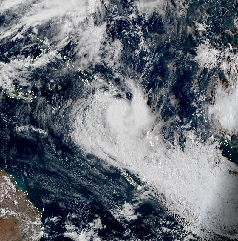
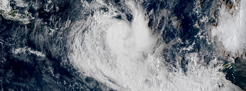
Tropical Cyclone "Liua" at 04:50 UTC on September 27, 2018. Credit: JMA/Himawari-8, RAMMB/CIRA
Liua formed from a disturbance located in the Australian region basin. It crossed into the South Pacific basin on September 26, and was designated as Tropical Depression 01F by RSMC Nadi. Late on September 26, the storm intensified into a tropical cyclone and was given the name Liua.
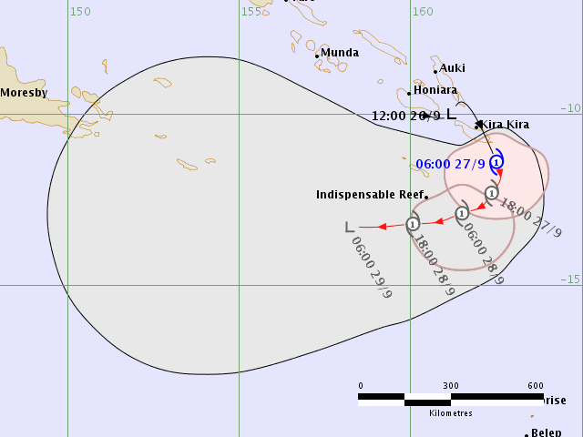
The cyclone is currently located over the Solomon's Makira Island and is forecast to develop into a Category 2 (of 5) storm on the Australian tropical cyclone intensity scale (89 – 117 km/h / 55 – 73 mph).
At 03:00 UTC on September 27, the center of Tropical Cyclone "Liua" was located approximately 970 km (600 miles) northwest of Port Vila, Vanuatu and has tracked SW at 15 km/h (9 mph) over the past six hours. The storm had maximum 1-minute sustained winds of 65 km/h (52 mph).
The environmental analysis shows the cyclone is located in an unfavorable area of increasing vertical wind shear, although strong poleward outflow is helping to maintain convection and sea surface temperatures are currently favorable.
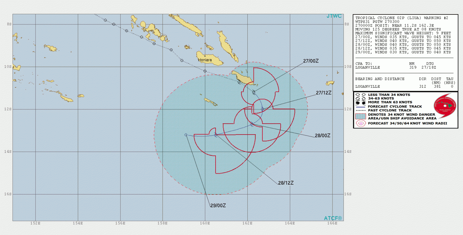
Liua is forecast to marginally intensify to 75 km/h (46 mph) over the next 12 hours, then begin to weaken after 03:00 UTC, September 28 as it enters more unfavorable environment, JTWC forecasters said.
The storm is expected to dissipate over water by 03:00 UTC, September 29.
Featured image credit: JMA/Himawari-8, RAMMB/CIRA
^ Oh look: climate science deniers have found The Watchers.
Excellent, the surf continues, although not for long as Liua is a flash in the pan (and to think the climate™ was just the ‘same’ back in 1950, almost 70 years ago). As for Chris Brandolino, where was he when blizzard after freezing snow blizzard buried New Zealand and Australia’s mountains in snow this winter? All very hush-hush, yet as soon as a little swirl of cloud appears, NIWA’s clown appears.
Liua, ‘lee-waa’, is a lovely name, however. Safe sailing on high seas, everyone.