Hurricane “Florence” forecast to stall or move very slowly along the coast, produce prolonged period of very dangerous conditions
Hurricane "Florence" is approaching the United States today and is forecast to bring prolonged life-threatening impacts to the southeastern states through the weekend. The storm will bring life-threatening storm surge, flash flooding, and destructive winds to much of the North and South Carolina coastline over the next several days, NHC warns. The hurricane is expected to stall or move very slowly along the coast bringing a prolonged period of dangerous conditions to the region.
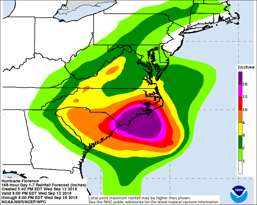
Heavy and excessive rainfall with 508 to 762 mm (20 to 30 inches) and isolated 1 016 mm (40 inches) of rainfall is expected in coastal North Carolina. This rainfall would produce catastrophic flash flooding and significant river flooding.
South Carolina, western and northern North Carolina can expect 127 to 254 mm (5 to 10 inches), and isolated 508 mm (20 inches).
76 to 152 mm (3 to 6 inches), with isolated amounts up to 305 mm (12 inches) are expected elsewhere in the Appalachians and Mid-Atlantic states.
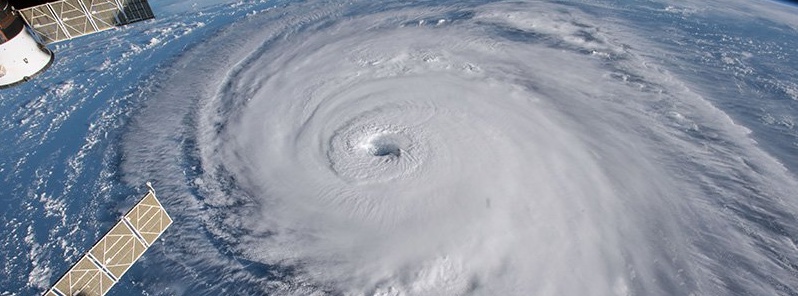
Hurricane "Florence" on September 12, 2018. Credit: NASA/ISS
As of 06:00 UTC (02:00 EDT) today, a Storm Surge Warning is in effect for:
- South Santee River South Carolina to Duck North Carolina
- Albemarle and Pamlico Sounds, including the Neuse and Pamlico Rivers
A Storm Surge Watch is in effect for:
- Edisto Beach, South Carolina to South Santee River, South Carolina
- North of Duck, North Carolina to the North Carolina/Virginia border
A Hurricane Warning is in effect for:
- South Santee River, South Carolina to Duck, North Carolina
- Albemarle and Pamlico Sounds
A Hurricane Watch is in effect for:
- Edisto Beach, South Carolina to South Santee River, South Carolina
A Tropical Storm Warning is in effect for:
- North of Duck, North Carolina to the North Carolina/Virginia border
A Tropical Storm Watch is in effect for:
- North of the North Carolina/Virginia border to Cape Charles Light, Virginia
- Chesapeake Bay south of New Point Comfort
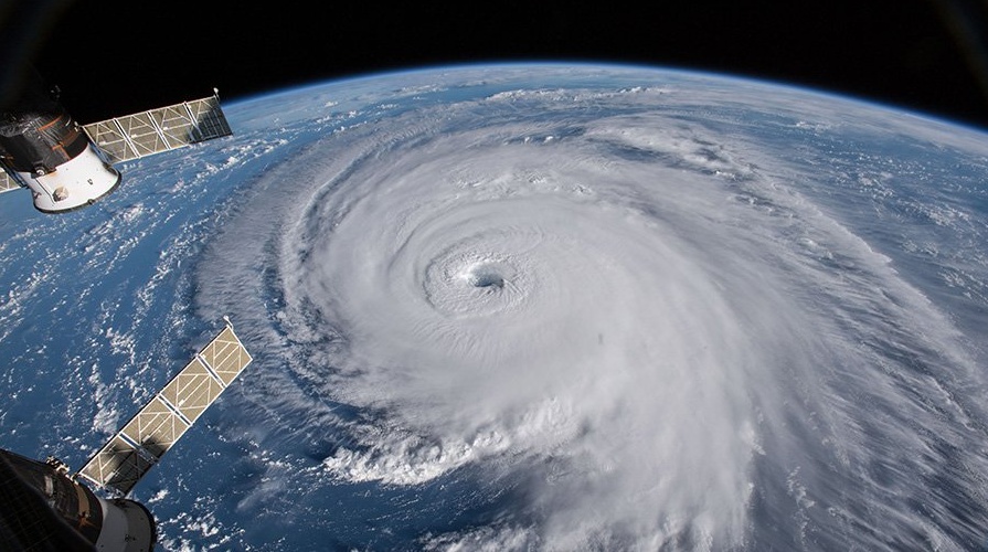
Hurricane "Florence" on September 12, 2018. Credit: NASA/ISS
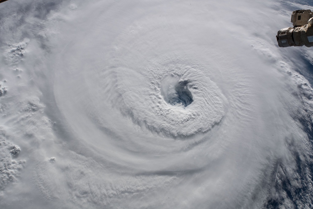
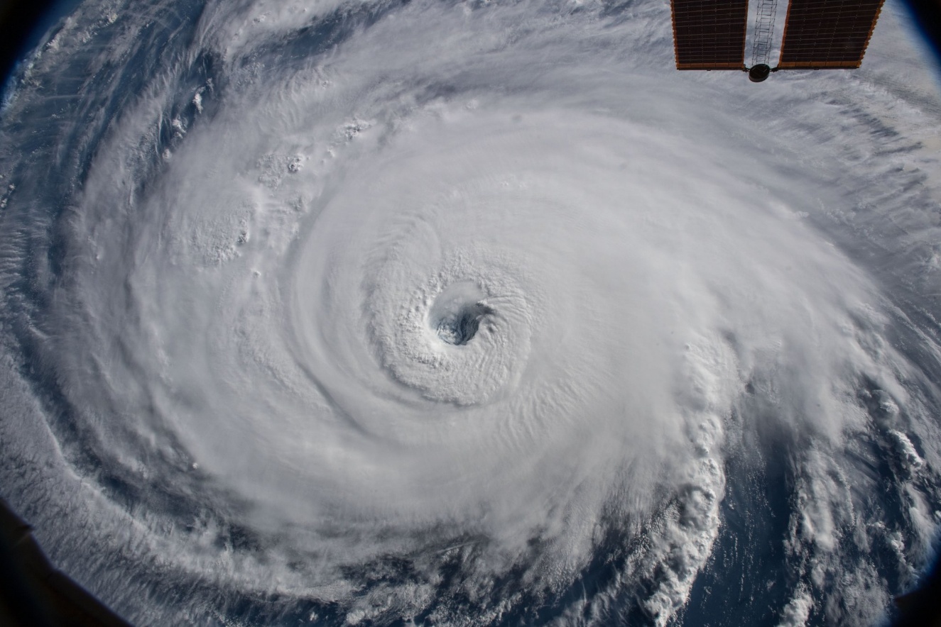
Hurricane "Florence" on September 12, 2018. Credit: NASA/ISS
At 06:00 UTC on September 13, the center of Hurricane "Florence" was located about 375 km (235 miles) WSE of Wilmington, North Carolina and 450 km (280 miles) ESE of Myrtle Beach, South Carolina. Its maximum sustained winds were 175 km/h (110 mph), placing it on the upper edge of Category 2 system on the Saffir-Simpson Hurricane Wind Scale. Little change in strength is expected before the center reaches the coast, with weakening expected after the center moves inland.
The hurricane is moving toward the northwest near 28 km/h (17 mph), and this general motion, accompanied by a gradual decrease in forward speed, is expected to continue through today.
A turn to the WNW and W at an even slower forward speed is expected tonight and Friday, September 14, and a slow WSW motion is forecast Friday night and Saturday, September 15.
On the current forecast track, the center of Florence will approach the coasts of North and South Carolina later today (EDT), then move near or over the coast of southern North Carolina and eastern South Carolina in the hurricane warning area tonight and Friday. A slow motion over eastern South Carolina is forecast Friday night and Saturday.
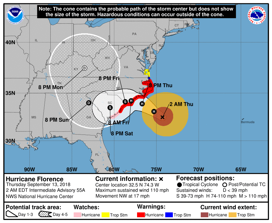
Hurricane-force winds extend outward up to 130 km (80 miles) from the center and tropical-storm-force winds extend outward up to 315 km (195 miles).
The latest minimum central pressure estimated from data from an Air Force Reserve Hurricane Hunter aircraft is 956 hPa.
Hazards affecting land
Storm surge
The combination of a dangerous storm surge and the tide will cause normally dry areas near the coast to be flooded by rising waters moving inland from the shoreline.
The water has the potential to reach the following heights above ground if peak surge occurs at the time of high tide:
- Cape Fear NC to Cape Lookout NC, including the Neuse, Pamlico, Pungo, and Bay Rivers: 2.7 – 4 m (9 – 13 feet)
- North Myrtle Beach SC to Cape Fear NC: 1.8 – 2.7 m (6-9 feet)
- Cape Lookout NC to Ocracoke Inlet NC: 1.8 – 2.7 m (6-9 feet)
- South Santee River SC to North Myrtle Beach SC: 1.2 – 2.7 m (4-6 feet)
- Ocracoke Inlet NC to Salvo NC: 1.2 – 2.7 m (4-6 feet)
- Salvo NC to North Carolina/Virginia Border: 0.6 – 1.2 m (2-4 feet)
- Edisto Beach SC to South Santee River SC: 0.6 – 1.2 m (2-4 feet)
The deepest water will occur along the immediate coast in areas of onshore winds, where the surge will be accompanied by large and destructive waves.
Surge-related flooding depends on the relative timing of the surge and the tidal cycle, and can vary greatly over short distances.
Rainfall
Florence is expected to produce heavy and excessive rainfall in the following areas:
- Coastal North Carolina: 508 to 762 mm (20 to 30 inches), isolated 1 016 mm (40 inches). This rainfall would produce catastrophic flash flooding and significant river flooding.
- South Carolina, western and northern North Carolina: 127 – 254 mm (5 to 10 inches), isolated 508 mm (20 inches).
- Elsewhere in the Appalachians and Mid-Atlantic states: 76 – 152 mm (3 to 6 inches), isolated 305 mm (12 inches).
Wind
Hurricane conditions are expected to reach the coast within the hurricane warning area this evening or early Friday (EDT).
Winds are expected to first reach tropical storm strength by late this morning or early afternoon today, making outside preparations difficult or dangerous.
Preparations to protect life and property should be rushed to completion.
Tornadoes
A few tornadoes are possible in eastern North Carolina through Friday.
Surf
Swells generated by Florence are affecting Bermuda, portions of the U.S. East Coast, and the northwestern and central Bahamas. These swells are likely to cause life-threatening surf and rip current conditions.
Featured image: Hurricane "Florence" on September 12, 2018. Credit: NASA/ISS
Does anyone else believe that this is a controlled weather event? – controlled by evil people with man-made machines
Jeremiah 25:32 Thus says the Lord of hosts behold, evil is going forth from nation to nation, And a great storm is being stirred up from the remotest parts of the earth. Indeed God will be faithful to his promises with the true children of Israel Act 7:5-7