Hurricane and storm surge warnings issued, more than 1.5 million evacuated as extremely dangerous Hurricane “Florence” eyes Carolinas
The National Weather Service has issued hurricane and storm surge warnings for portions of the coasts of North and South Carolina on September 11, 2018, as extremely dangerous Hurricane "Florence" continues heading toward the East Coast U.S. Landfall is expected between northern South Carolina and North Carolina's Outer Banks on September 13. Florence could linger over the Southeast for several days after landfall, leading to catastrophic flash flooding and major river flooding in parts of the Carolinas, Virginia and neighboring states.
Governors of Maryland, Virginia, North Carolina and South Carolina have declared states of emergency ahead of the storm and more than 1.5 million people have already evacuated coastal areas.
Computer-model forecasts generally project Florence to make landfall between northern South Carolina and North Carolina’s Outer Banks as a Category 4 Hurricane on Thursday, September 13.
While shifts in the track are still possible, storm impacts will expand great distances beyond where landfall occurs and there is a potential for Florence's forward speed to slow and possibly stall, leading to more than 500 mm (20 inches) of rainfall on some of the already saturated ground which would lead to catastrophic flash flooding and major river flooding in parts of the Carolinas, Virginia and other neighboring states.
If Florence makes landfall as a Category 4 in North Carolina, it would be the strongest storm to come ashore that far north on record.
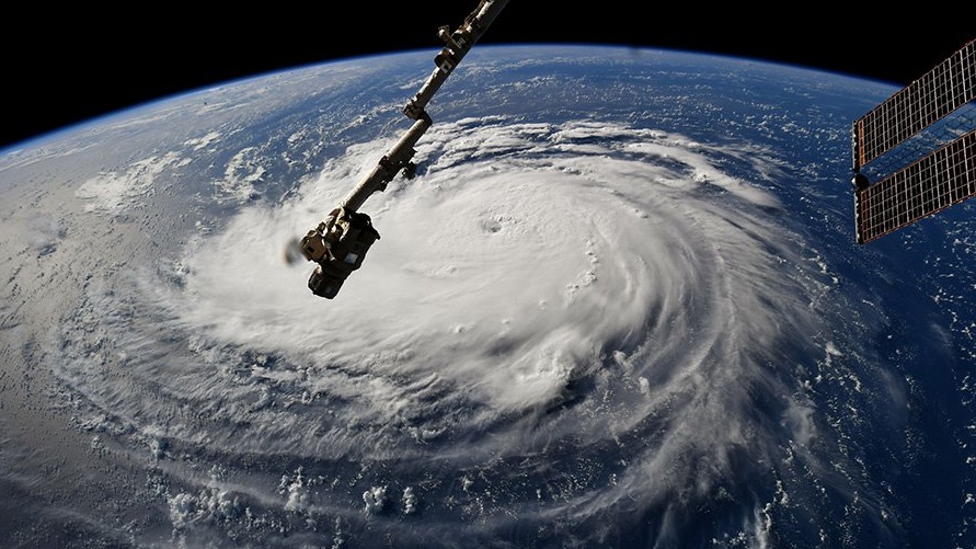
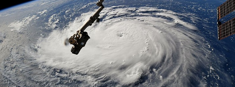
Hurricane "Florence" as seen from ISS on September 10, 2018. Credit: NASA/ISS
In general, most of hurricane damage and loss of life occurs not on the coast, but from flooding as the result of heavy rain. In all likelihood, this will be the case with Hurricane Florence as well, according to AccuWeather President and Founder Dr. Joel N. Myers.
"There could be devastating floods well in from the coast back in the hills and mountains of North Carolina, Virginia and West Virginia," Myers said.
"There’s never been a storm like Florence," AccuWeather Vice President of Forecasting and Graphics Operations Marshall Moss said. "It was located father north in the Atlantic than any other storm to ever hit the Carolinas, so what we’re forecasting is unprecedented. Also, most storms coming into the Carolinas tend to move northward, and this storm looks like it’s going to stall over the region and potentially bring tremendous, life-threatening flooding."
Cameras outside the station captured views of Hurricane Florence in the Atlantic at 8:10 a.m. EDT Sept. 10. With winds of 115 miles an hour it could make landfall along the eastern seaboard of the U.S. late Thursday or early Friday. pic.twitter.com/DhEHhSeeDx
— Intl. Space Station (@Space_Station) September 10, 2018
At 09:00 UTC on September 11, the center of Hurricane "Florence" was located about 660 km (410 miles) S out Bermuda and 1 570 km (975 miles) ESE of Cape Fear, North Carolina. Its maximum sustained winds were 220 km/h (140 mph), making it a Category 4 hurricane on the Saffir-Simpson scale. The storm was moving WNW at 24 km/h (15 mph) with minimum central pressure 944 hPa.
A Storm Surge Watch is in effect for Edisto Beach, South Carolina to the North Carolina-Virginia border, Albemarle and Pamlico Sounds, including the Neuse and Pamlico Rivers. A Storm Surge Watch means there is a possibility of life-threatening inundation, from rising water moving inland from the coastline, in the indicated locations during the next 48 hours.
A Hurricane Watch is in effect for Edisto Beach, South Carolina to the North Carolina-Virginia border, Albemarle and Pamlico Sounds. A Hurricane Watch means that hurricane conditions are possible within the watch area. A watch is typically issued 48 hours before the anticipated first occurrence of tropical-storm-force winds, conditions that make outside preparations difficult or dangerous.
Florence will hit the region which received 150 to 300% of its normal rainfall since May.
Interests elsewhere in the southeastern and mid-Atlantic states should monitor the progress of Florence, NHC said, adding that additional watches may be required later today.
The combination of a dangerous storm surge and the tide will cause normally dry areas near the coast to be flooded by rising waters moving inland from the shoreline. The water has the potential to reach the following heights above ground if peak surge occurs at the time of high tide:
- Edisto Beach to Murrells Inlet: 60 – 120 cm (2 – 4 feet)
- Murrells Inlet to Cape Fear: 120 to 180 cm (4 – 6 feet)
- Cape Fear to Cape Lookout, including The Neuse and Pamlico River: 180 to 360 cm (6 – 12 feet)
- Cape Lookout to Ocracoke Inlet: 150 to 240 cm (5 – 8 feet)
- Ocracoke Inlet to North Carolina/Virginia Border: 90 to 150 cm (3 – 5 feet)
The deepest water will occur along the immediate coast in areas of onshore winds, where the surge will be accompanied by large and destructive waves. Surge-related flooding depends on the relative timing of the surge and the tidal cycle, and can vary greatly over short distances.
Florence is expected to produce total rainfall accumulations of 381 to 508 mm (15 to 20 inches) with isolated maxima to 762 mm (30 inches) near Florence's track over portions of North Carolina, Virginia, and northern South Carolina through Saturday, September 15. This rainfall may produce life-threatening flash flooding.
Hurricane conditions are possible within the watch area by late Thursday or Thursday night, September 13, with tropical storm conditions possible by Thursday morning.
Swells generated by Florence are affecting Bermuda and portions of the U.S. East Coast. These swells are likely to cause life-threatening surf and rip current conditions.
Featured image credit: NASA/ISS
See the clouds from the east and from the North to the south! Their appearance is exceedingly threatening,full of wrath and storm. That shall pour out a heavy tempest on the earth, and their own tempest; and there shall be blood from the sword as high as a horse’s belly and a man’s thigh and a camel’s hock. And there shall be fear and great trembling on the the earth. 2 Esdras 15:34-37.