Midwest: Severe storms lead to widespread flooding and high water rescues, leave 110 000 without power

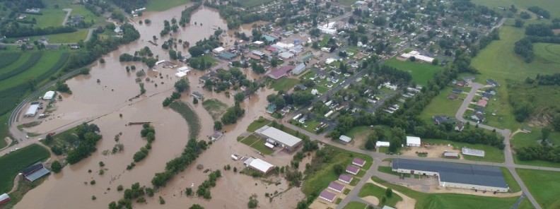
Another round of severe thunderstorms swept through parts of north-central United States this week, causing damaging winds and heavy rains. Widespread flooding was reported across Wisconsin. The flooding has damaged roads, businesses and private residences in multiple counties. At least one person was injured near Thornton, Iowa after a tractor-trailer was blown over on Interstate 35.
The worst hit was the region from central Wisconsin to eastern Iowa, where several tornadoes touched down. The strongest winds were measured at Iowa City Airport, at 133 km/h (83 mph).
More than 110 000 customers in Michigan, Wisconsin an Iowa were left without power on August 28; over 60 000 in Michigan, 40 000 in Wisconsin and 13 000 in Iowa.
At least two tornadoes touched down in Wisconsin on the same day. The twisters, which touched down in southwest Fond du Lac County near Brandon and north of Kiel near the Calumet and Manitowoc County lines, downed trees and power lines, while also damaging multiple buildings. No injuries were reported.
Several parts of the state have experienced torrential rainfalls in the past two weeks with some areas receiving more than 356 mm (14 inches) of rain, Gov. Scott Walker said August 29. This has caused lake levels to rise in Dane County and pushed portions of the Kickapoo and Baraboo rivers to record levels.
Numerous residents were rescued as life-threatening floods hit parts of the state's southwest into August 28. The floods were so destructive, they forced Gov. Walker to declare a state of emergency for several counties, including Fond du Lac, Juneau, La Crosse, Monroe, Vernon, and Washington. Some of these areas received nearly 305 mm (12 inches) of rain, AccuWeather Meteorologist Isaac Longley reports.
"It all began after rounds of heavy rain and thunderstorms rolled through the morning hours of August 27," he said. "After a break in the rain during the afternoon, a line of violent thunderstorms erupted over southern Minnesota and advanced eastward into Wisconsin, the same area where heavy rain had fallen just earlier in the day."
According to the National Weather Service, the Kickapoo River in Rockton reached a near-record level of 6.37 m (20.9 feet) on the morning of August 28. This is well above the flooding state of 4.87 m (16 feet), for the second time this year. Several other rivers and streams also reached near-record levels, Longley said.
High-water rescues were reported in Rockton and in La Crosse at the Brookview Mobile Home Park. Widespread evacuations were carried out in Vernon and La Crosse counties.
A strong cold front is slowly moving south and east, stretching from New England to the central and Southern Plains, NWS forecaster Wix noted early Thursday, August 30.
As this boundary slows and stalls across the Mid-Atlantic and into the Middle Mississippi Valley today, more rounds of showers and thunderstorms are expected along the boundary.
Some of these thunderstorms could produce locally heavy rainfall–thus a marginal risk of flash flooding is possible from the Mid Atlantic inland through the Tennessee Valley today.
Meanwhile, a portion of the front across the Southern and Central Plains will shift northward and transition into a warm front today, guided by a developing area of low pressure. As this frontal boundary continues to traverse eastward across the Plains and towards the Mississippi River Valley, thunderstorms capable of producing heavy rainfall are forecast for tonight night and Friday morning.
The combination of heavy rain potential and already saturated soils have led to a slight risk of flash flooding for the middle Missouri Valley this evening and overnight.
The Storm Prediction Center has also issued a marginal risk of severe thunderstorms stretching from Southern Minnesota southward into eastern Kansas and western Missouri during this time frame as well.
By Friday, August 31, the cluster of storms will continue impacting the middle Mississippi Valley, especially as the center of low pressure continues to strengthen, and a deep layer of warm moist air is lifted northward from the Gulf of Mexico aiding in storm development.
This will be further exasperated by another cold front dropping southeast from Canada into the northern Plains, bringing with it a surge of colder air.
The clash of the two air masses could lead to strong storms across the Mid and Upper Mississippi Valleys as well as into the far western Plains. This area has been outlined as being in a slight risk for severe thunderstorms by the Storm Prediction Center for Friday.
The Weather Prediction Center has also outlined much of the Upper and Mid Mississippi Valleys as being in a slight risk for flash flooding as well.
Featured image credit: Randy Humfeld

Commenting rules and guidelines
We value the thoughts and opinions of our readers and welcome healthy discussions on our website. In order to maintain a respectful and positive community, we ask that all commenters follow these rules:
We reserve the right to remove any comments that violate these rules. By commenting on our website, you agree to abide by these guidelines. Thank you for helping to create a positive and welcoming environment for all.