First winter weather advisories of the 2018/19 season issued for parts of the Rockies of Montana and Wyoming
First winter weather advisories for the upcoming 2018/19 winter season have been issued by the NWS for parts of the Rockies of Montana and Wyoming. NWS expects several inches of wet snow into early Tuesday, August 28 above 1 800 m (6 000 feet). These are the first winter weather advisories to be issued by the NWS anywhere in the Lower 48 for the upcoming season.
The last time a winter weather advisory was issued anywhere in the Lower 48 was in June 2018 when a late-season storm brought snow the West.
TWC's Chris Dolce said impacts from this early-season snow will be limited, but the NWS said higher elevations of the Beartooth Highway, one route connecting southwest Montana to Yellowstone National Park, could have hazardous travel conditions and may have closures, at times.
Accumulating snow is expected in the highest peaks of northwestern Wyoming, southern and western Montana and adjacent portions of Idaho.
As of 7 am, @GlacierNPS park ranger measured an inch of new #snow on grassy areas at Logan Pass. #BringOnSkiSeason #MTwx pic.twitter.com/hMNJ9G1UdK
— NWS Missoula (@NWSMissoula) August 27, 2018
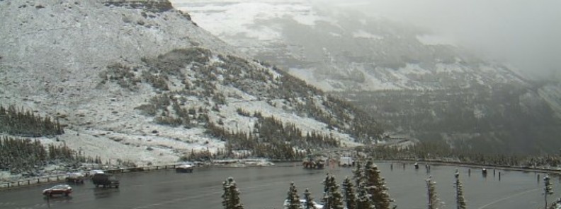
Check out these #BeforeAndAfter of @GlacierNPS! We traded smoky air for a more fall-like scene with fresh air. #MTwx #glaciernationalpark
Cameras courtesy of GNP pic.twitter.com/BEBwm1sHOm— NWS Missoula (@NWSMissoula) August 27, 2018
Running with the "S" word #snow, here are a couple of locations in Montana & Idaho with the dates and amounts of the earliest 1 inch or greater of snow… Enjoy! #snow #MTwx #IDwx pic.twitter.com/YkNfUgw9ty
— NWS Missoula (@NWSMissoula) August 27, 2018
An upper level trough is expected across the northwestern U.S. and the Dakotas through Tuesday, August 28 while an upper level ridge continues to build across the eastern third of the nation.
Meanwhile, at the surface, an active frontal zone is currently in place, draping from the Intermountain West northeast into the Northern Plains and Upper Mississippi Valley.
A strong surge of warm, moist air is being pulled northward from the Gulf of Mexico towards the frontal boundary, resulting in showers and thunderstorms along and just ahead of the boundary.
The best shower and thunderstorm activity will be found near the centers of low pressure embedded within the northern portion of the boundary.
The Storm Prediction Center has outlined a large area encompassing much of the Upper Mississippi Valley and Upper Great Lakes region as being in a slight risk of severe storms through today.
The Weather Prediction Center has also outlined much of the same region as being in a slight risk for excessive rainfall today as well.
The risk of excessive rainfall and severe storms will shift slightly farther southeast for Tuesday, stretching from the Mid Mississippi Valley northeast into the Upper Great Lakes.
While a cooler airmass is in place behind the frontal boundary, the strong ridge in place across the eastern and southeastern U.S. will make it hard for the front to move east quickly. As a result, much of the southern and eastern U.S. will continue to see hot and humid southerly flow for much of the week.
Featured image credit: U.S. National Parks Service
winters will be a thing of the past said the progressive liberal globalist.