Bud about to make landfall, rain over southern Arizona and New Mexico expected late Friday into Saturday
Tropical Storm "Bud" is producing strong winds across southern Baja California Sur on June 14, 2018, with landfall expected by the end of the day still as a tropical storm. Bud should decay into a tropical depression by Friday and become a remnant low while it moves inland over mainland Mexico.
At 18:00 UTC today, the center of Tropical Storm "Bud," the second named storm of the 2018 East Pacific hurricane season, was located 125 km (70 miles) SSW of Cabo San Lucas, Mexico. Its maximum sustained winds at the time were 75 km/h (45 mph) and minimum central pressure 1 000 hPa, according to the National Weather Service. The storm was moving to the NNW at 11 km/h (7 mph).
On the forecast track, the center of Bud is expected to cross southern Baja California Sur later today (MDT) and move over the Gulf of California on Friday, June 15. The weakening cyclone or its remnants are expected to move over mainland Mexico by Friday night or early Saturday and then dissipate.
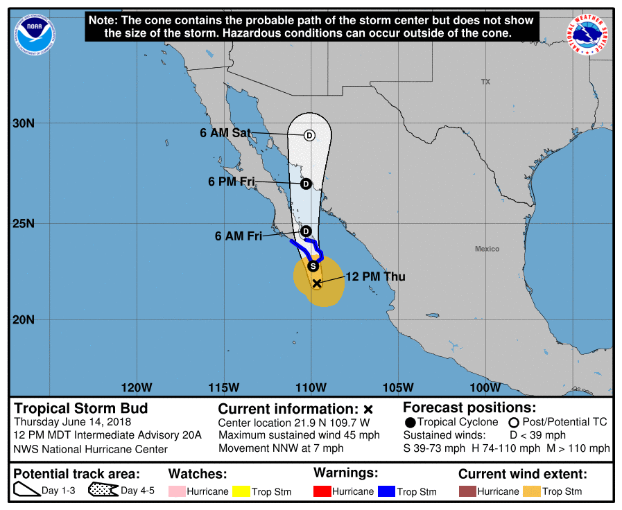
This system is forecast to still be a tropical storm when the center reaches southern Baja California Sur, but is expected to weaken as the cyclone moves across the peninsula. Bud should decay into a tropical depression by Friday and become a remnant low while it moves inland over mainland Mexico.
Tropical-storm-force winds extend outward up to 165 km (105 miles) from the center. A Mexican Navy automatic weather station located in the Port of Cabo San Lucas recently reported a wind gust to 111 mph (69 km/h).
Bud is expected to produce 51 – 102 mm (2 to 4 inches) of rain with isolated totals of 152 mm (6 inches) across southern portions of Baja California Sur and southern Sonora in northwestern Mexico through Saturday. These rains could cause life-threatening flash floods and mudslides.
Additional rainfall of 25 to 51 mm (1 to 2 inches) is expected across much of Sinaloa and Durango, with isolated maximum amounts of 76 mm (3 inches).
Swells generated by Bud will continue to affect portions of the coast of southwestern Mexico, western mainland Mexico, and the southern Baja California Peninsula during the next couple of days. These swells are likely to cause life-threatening surf and rip current conditions.
Tropical moisture associated with its future remnants will begin impinging on southern Arizona and New Mexico by later Friday and into Saturday. Anomalous moisture levels for this time of year, prior to the typical onset of monsoon season, will result in scattered to numerous showers and storms, with the possibility that some could produce flooding issues.
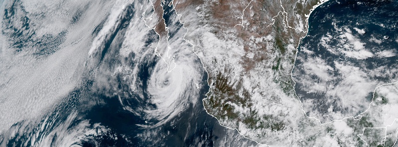
Featured image: Tropical Storm "Bud" at 20:00 UTC on June 14, 2018. Credit: NOAA/GOES-East
Commenting rules and guidelines
We value the thoughts and opinions of our readers and welcome healthy discussions on our website. In order to maintain a respectful and positive community, we ask that all commenters follow these rules:
We reserve the right to remove any comments that violate these rules. By commenting on our website, you agree to abide by these guidelines. Thank you for helping to create a positive and welcoming environment for all.