Severe weather hits Texas, heavy rainfall, floods and tornadoes
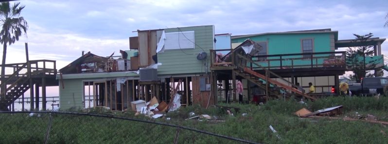
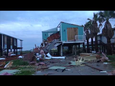
Severe storms caused property damage and flash flooding across parts of southern Texas on Wednesday and Thursday, March 28 and 29, 2018. On Wednesday afternoon heavy rain turned roads into rivers on the campus of Texas A&M University in College Station, Texas. In addition, seven people were rescued after the second story of a home was blown off by a possible tornado in Holiday Beach near Rockport in Aransas County, Texas. Incident was reported on March 29, 06:25 UTC (01:25 local time).
The College Station Police Department reported that several cars throughout the city stalled out after attempting to drive through floodwaters. Many roads were closed in the city due to flooding.
Both San Antonio and Austin, Texas, established daily maximum rainfall records for the month of March on March 28, 2018.
San Antonio received 89 mm (3.51 inches), surpassing the old record of 66.8 mm (2.63 inches) on March 29, 1922. Austin-Bergstrom International Airport reported a total of 152 mm (5.99 inches), breaking the previous record of 68.3 mm (2.69 inches) on March 20, 2012, according to the National Weather Service (NWS).
At least 45 roads were closed in Bexar County, Texas, on Wednesday due to high water, leading to many traffic problems, according to My San Antonio.
The NWS first issued the Tornado Warning around 06:00 UTC (01:00 local time). According to local media reports, around 06:30 UTC (01:30 local time) the workers of the home got the alert on their phones.
Shortly after, a loud boom was heard, the doors flew open and the roof blew off the home and landed across the street trapping seven people. The home was being rebuilt after Hurricane Harvey previously destroyed it.
Power lines are also down in the road with debris scattered around the scene and there are reports of many homes with windows blown out.
"Once I knew the roof was gone when my back started getting wet and I look up and I saw lightning. I thought, 'Are you serious? The roof is gone." a worker Joe Lopez said.
At this time there are no reports of injuries.
The NWS will work on Thursday to determine if a confirmed tornado touched down in the area.
A complicated storm over the Lower/Middle Mississippi Valley will move northeastward to the Canadian Maritimes by Friday evening, NWS said.
Showers and thunderstorms will develop over parts of the Lower Mississippi Valley that will move off most of the Southeast Coast by Friday evening.
Rain will also develop over parts of the Southern Plains/Middle Mississippi Valley into parts of the Tennessee/Ohio Valleys that will lift northward into the Lower Great Lakes/Northeast by Thursday evening. The rain will end over the Middle/Lower Mississippi Valley by Thursday evening, too.
Overnight Thursday, the rain will move into the Mid-Atlantic and move off most of the Northeast Coast by Friday evening. Some rain will lingering over parts of the Ohio Valley into the Mid-Atlantic through Friday evening.
Featured image credit: StormChasingVideo
Commenting rules and guidelines
We value the thoughts and opinions of our readers and welcome healthy discussions on our website. In order to maintain a respectful and positive community, we ask that all commenters follow these rules.