Extremely heavy rain floods Queensland, Australia
Ex-Tropical Cyclone "Nora" dumped extremely heavy rain on parts of Queensland over the past 24 – 48 hours, causing major floods and emergency evacuations. Many locations exceeded or even doubled their March average rainfall.
Exceptional rainfall totals have been recorded this week in Tropical North Queensland, and particularly the last 24 hrs around Cairns. The rain is a result of ex-Tropical Cyclone "Nora," which currently lies over the Cape York Peninsula, and connects to a monsoon trough towards the east, bringing very moist air from the Coral Sea.

Port Douglas, for example, recorded an extraordinary 593 mm (23 inches) of rainfall in 24 hours to 09:00 AEST on March 26. Widespread daily rainfall of 100 – 400 mm (3.93 – 15.7 inches) were registered in 24 hours to 09:00 AEST today along the coastal strip from Cairns to Townsville.
Cairns received more than 260 mm (10.23 inches) of rain in 24 hours with some areas to the north recording more than 500 mm (19.68 inches):
Moderate to major flood warnings are current for various catchments near Cairns including the Barron River which is seeing its highest levels in 18 years.
There is a severe weather warning for heavy rain and damaging winds for parts of the North Tropical Coast, Herbert and Lower Burdekin and Northern Goldfields Districts.
More heavy rain has turned Barron Falls in @ABCFarNorth Queensland into a raging torrent (Credit: Paul Webster) @ABCemergency pic.twitter.com/S9aFwXPymB
— ABC News (@abcnews) March 27, 2018
For the remainder of Tuesday and into Wednesday, further falls of 50 – 100 mm (1.9 – 3.93 inches) and isolated falls in excess of 200 mm (7.87 inches) can be expected, but conditions should ease by Thursday as ex-tropical cyclone Nora begins to move away and weakens, BOM said.
From there, all eyes will be on ex-Tropical Cyclone Iris in the Coral Sea, which formed near Vanuatu on Saturday, March 24. This system is now a tropical low and will begin to move towards the Queensland coast over the coming days. Wind and swell pick up from Wednesday evening, March 28 from the NSW border to the Capricornia coast, and warnings will be issued.
"Beyond Thursday, ex-Tropical Cyclone 'Iris' is likely to move north-west but remain offshore. There is uncertainty as to how this tropical low will develop, but we could see heavy rainfall and flooding once again about the northeast tropical coast from Sunday and into next week, and this is something that forecasters will monitor closely," BOM said.
If you're living or traveling along the Queensland coast this week or the Easter long weekend, please stay up to date with the latest warnings, and always follow the advice of the Queensland Fire and Emergency Services.
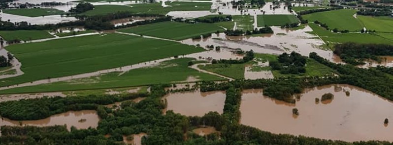
Featured image: Flooding in Cairns, Queensland on March 26, 2018. Credit: Ryan Lancini
Commenting rules and guidelines
We value the thoughts and opinions of our readers and welcome healthy discussions on our website. In order to maintain a respectful and positive community, we ask that all commenters follow these rules.