Another nor’easter to slam the storm-weary Mid-Atlantic and Northeast
Another nor’easter will make its way up the East Coast Wednesday into Thursday, March 7 into 8, 2018, the second to hit the region in less than a week but much snowier this time, with totals expected to be over a 30 cm (1 foot) for some areas west of I-95. Major cities will be on the gradient in between substantial snowfall and light snowfall. Gusty winds and minor-to-moderate coastal flooding is also expected. More than 15 million people are under some kind of winter weather alert and more than 150 000 still without power since the last nor'easter just a few days ago.
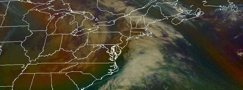
A surface low pressure and an associated frontal system is quickly transitioning into to a nor'easter and will spread snow to much of the northern Mid-Atlantic and Northeast today through the end of the week, NWS forecaster Amy Campbell noted 03:06 EST (08:06 UTC).
Numerous Winter Storm Warnings and Winter Weather Advisories are in effect across portions of the northern Mid-Atlantic and the Northeast, Campbell added.
The storm is expected to track offshore the Del-Mar-Va peninsula northward while paralleling the Northeast Coast. By Thursday evening, snow accumulations could easily surpass 30 cm (1 foot) for areas west of the I-95 corridor.
This morning on AMHQ- We're tracking Winter Storm #Quinn as it brings heavy, wet #snow into the Northeast. Tune in for the latest forecast and updates.
Here's what we know right now: pic.twitter.com/pUnT3Igwul
— AMHQ (@AMHQ) March 7, 2018
Winter Storm #Quinn will create dangerous #travel conditions in the Northeast. If you can stay home, do so. BUT if you do have to drive, here is how to do it safely. pic.twitter.com/clTS11qs3B
— AMHQ (@AMHQ) March 7, 2018
The major cities will be on the gradient in between the substantial snowfall totals and light snowfall totals, so there is uncertainty in how much snow will fall in areas such as New York City.
This storm is named Winter Storm Quinn by The Weather Channel. Quinn brought heavy snow to the Mountain West last week and pounded the northern Plains and upper Midwest Monday into Tuesday.
Quinn will now hammer the storm-weary Northeast with heavy snow and strong winds, triggering additional power outages and tree damage just 5 days after another nor'easter knocked out power to over 2 million.
As of 06:00 EST today, there are still tens of thousands without power across the northeast.
The most affected states are Pennsylvania with 40 802 customers without power, New York with 36 807, New Jersey with 26 323 and Maryland with 8 302. In total, more than 150 000 customers are still without power.
Meanwhile, snow will persist over the Great Lakes region over the next couple of days as low pressure hangs around – with an additional 15 – 20 cm (6 to 8 inches) possible. For the Southeast, showers and thunderstorms are expected for portions of central and southern Florida today as the cold front pushes south.
Across the West, conditions will generally be dry through this afternoon before a low approaches the coast. Rain and mountain snow will spread into northern California and the Pacific Northwest this evening and into the Northern Rockies on Thursday. Rain and snow totals will be fairly light for this system through Thursday.
Featured image credit: NOAA GOES-East acquired 11:45 UTC, March 7, 2018
I sell homemade soy candles for emergencies. Right now, those candles would come in handy.