Massive eruption at Sinabung volcano, ash to 16.7 km (55 000 feet) a.s.l.
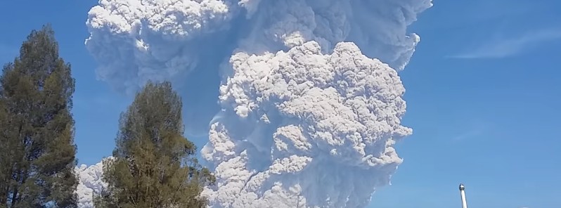
A high impact volcanic ash eruption started at Sinabung volcano, Indonesia at 01:53 UTC on Monday, February 19, 2018. Pyroclastic flows traveled 3.5 km (2.1 miles) and 4.9 km (3 miles) from the summit. Ash plume was reaching an altitude of 16.7 km (55 000 feet) above sea level, the Darwin VAAC reported 04:50 UTC. Aviation Color Code was raised from Orange to Red.
The eruption started at 01:53 UTC (08:53 local time) and lasted 4 minutes and 51 seconds, Sinabung Volcano Observatory reported.
Their best estimate of the ash cloud top at 02:13 UTC was 7.4 km (23 872 feet) above sea level. The observatory noted that the ash cloud is drifting to the east and southeast, adding that its top may be higher than what can be clearly observed from the ground. The Aviation Color Code was raised from Orange to Red.
"Pyroclastic flow is observed through the ESE slope to a distance of 3.5 km [2.1 miles] from the summit and through the south slope to a distance of 4.9 km [3 miles] from the summit," they said.
Major ashfall was reported around the volcano and visibility was down to only 5 to 10 meters (16 – 32 feet).
The volcanic ash cloud is reaching an altitude of 16.7 km (55 000 feet) above sea level and extending 46.3 km (28.7 miles) ENE, the Darwin VAAC reported 03:35 UTC. At the same time, the second volcanic ash cloud was reaching 7.6 km (25 000 feet) a.s.l. and extending 18.5 km (11.5 miles) S.
.png)
At 04:53 UTC, the Darwin VAAC said that one volcanic ash cloud was observed reaching an altitude of 13.7 km (45 000 feet) at 04:50 UTC and extending 138.9 km (86.3 miles) to the northwest, while the second volcanic ash cloud was reaching 6.7 km (22 000 feet) and extending 46.3 km (28.7 miles) to the south.
"High impact volcanic eruption is clearly observed on satellite imagery," they noted, adding that the 04:50 UTC volcanic ash cloud heights were estimated based on plume top IR temperature and 00:00 UTC February 19 Medan sounding.
Eruption of #Sinabung in #Indonesia – #Himawari true color pic.twitter.com/Yk6JVKNV3b
— Dan Lindsey (@DanLindsey77) February 19, 2018
Following the eruption at #Sinabung volcano this morning. The airspace above Northern-Sumatra currently looks like this via @flightradar24 . The Red VONA (Volcano Observatory Notice for Aviation) that was issued following the eruption, seems to be in place. pic.twitter.com/npWpsg8Wf9
— Øystein L. Andersen (@OysteinLAnderse) February 19, 2018
Gunung Sinabung meletus besar pagi ini. pic.twitter.com/AoKkuaZCXY
— Sutopo Purwo Nugroho (@Sutopo_PN) February 19, 2018
Gunung Sinabung meletus pagi ini dengan tinggi kolom abu mencapai kurang lebih 5.000 m disertai suara gemuruh dan disertai awan panas dengan jangkauan ke arah timur laut sejauh 3.500 m dan ke arah selatan sejauh 4.900 m. Tidak ada korban jiwa. @BNPB_Indonesia @RadioElshinta pic.twitter.com/5lmS3PNz0k
— Sutopo Purwo Nugroho (@Sutopo_PN) February 19, 2018
VONA Gunung Sinabung dinaikkan RED terkait letusan Gunung Sinabung pagi ini. Tinggi kolom abu mencapai kurang lebih 5000 m disertai suara gemuruh dan disertai awan panas dengan jangkauan ke arah timur laut sejauh 3500 m dan ke arah selatan sejauh 4900 m. @BNPB_Indonesia pic.twitter.com/0Qe43IZYII
— Sutopo Purwo Nugroho (@Sutopo_PN) February 19, 2018
Gunung Sinabung meletus dengan tinggi kolom abu vulkanik 5 km dan disertai luncuran awan panas 3,5-4,9 km. Tidak ada korban jiwa. pic.twitter.com/cAz8VLWzUo
— Sutopo Purwo Nugroho (@Sutopo_PN) February 19, 2018
Anak SD berteriak dan takut melihat dahsyatnya letusan Gunung Sinabung pagi tadi. Awan panas dengan suhu 600-800 derajat celcius menuruni lereng sejau 4,9 km. #Sinabung #SinabungErupsi @RadioElshinta @BNPB_Indonesia #VisitWonderfulIndonesia pic.twitter.com/HFMkZuPGts
— Sutopo Purwo Nugroho (@Sutopo_PN) February 19, 2018
Gunung Sinabung meletus pagi ini dengan tinggi kolom abu mencapai kurang lebih 5.000 m disertai suara gemuruh dan disertai awan panas dengan jangkauan ke arah timur laut sejauh 3.500 m dan ke arah selatan sejauh 4.900 m. Tidak ada korban jiwa. @BNPB_Indonesia @RadioElshinta pic.twitter.com/D9dPE7anor
— Sutopo Purwo Nugroho (@Sutopo_PN) February 19, 2018
Dahsyatnya letusan Gunung Sinabung. Tinggi kolom hingga 5 km disertai luncuran awan panas hingga 4,9 km. Suara bergemuruh. Baru kali ini letusan disertai suara gemuruh sejak 2014-2018. Tidak ada korban jiwa. Semua penduduk di zona merah sudah lama diungsikan. #volcano #Sinabung pic.twitter.com/P2RRfMcm08
— Sutopo Purwo Nugroho (@Sutopo_PN) February 19, 2018
Kondisi desa payung pasca erupsi
Pagi rasa malam karna di selimuti debu langitnya
Pukul 10.00 wib tadi@infobencana pic.twitter.com/sHyRC1lvwc— Nada Gultom (@siitulang) February 19, 2018
SINABUNG JAYA. Warga Desa Gurukinayan dievakuasi menggunakan angkutan pedesaan saat letusan dahsyat Gunung Sinabung pagi tadi. Tidak ada korban jiwa. Warga yang mengungsi telah kembali ke rumahnya. #Sinabung @RadioElshinta @BNPB_Indonesia #VisitWonderfulIndonesia pic.twitter.com/R3jyL57gZG
— Sutopo Purwo Nugroho (@Sutopo_PN) February 19, 2018
Tanaman tonat dan lahan pertanian tertutup abu vulkanik tebal pascaletusan Gunung Sinabung (19/2/2018). Petani mengalami kerugian akibat tanaman pertanian mati. Petani menjadi tambah miskin. #SinabungErupsi #Sinabung #volcano #volcan @BNPB_Indonesia pic.twitter.com/j3PmZacbib
— Sutopo Purwo Nugroho (@Sutopo_PN) February 19, 2018
The National Disaster Mitigation Agency said there are no reports of fatalities and injuries.
Sinabung's first eruption in known history took place in August 2010. It lasted about a month and had Volcanic Explosivity Index of 2.
Seismicity fluctuated until September 2013, when dense white plumes started rising 100 to 150 m (328 to 492 feet) above the crater.
Sinabung's first major eruption in known history occurred on September 17, 2013 and the volcano remains active ever since. Tens of thousands have been evacuated.
Between February 2014 and May 2016, eruptions at Mount Sinabung claimed lives of 23 people.
Geological summary
Gunung Sinabung is a Pleistocene-to-Holocene stratovolcano with many lava flows on its flanks. The migration of summit vents along a N-S line gives the summit crater complex an elongated form. The youngest crater of this conical, 2 460-m-high (8 070 feet) andesitic-to-dacitic volcano is at the southern end of the four overlapping summit craters.
An unconfirmed eruption was noted in 1881, and solfataric activity was seen at the summit and upper flanks in 1912.
No confirmed historical eruptions were recorded prior to explosive eruptions during August – September 2010 that produced ash plumes to 5 km (16 404 feet) above the summit. (GVP)
Featured image: Eruption of Mount Sinabung on February 19, 2018. Credit: Polres Tanah Karo, Kabanjahe
Is this the volcano that went off 75,000 years ago and killed all but about 1,500 people?
55K feet for the ash? That will check global warming for 2018 & 2019.