Significant winter storm brings heavy snow and ice to Midwest, Plains

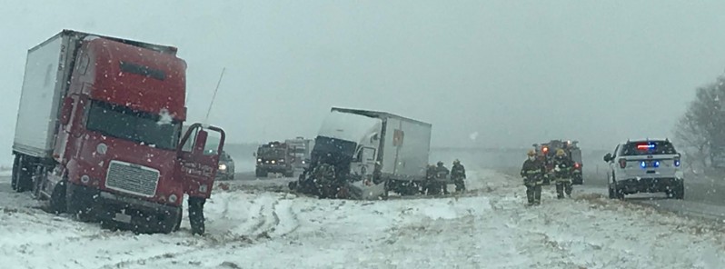
A strong winter storm is bringing heavy snow and ice from the Plains to the upper Midwest and western Great Lakes, US on Monday, January 22, 2018, causing major road and air traffic problems. The storm is named Jaxon by The Weather Channel.
Hundreds of flights were canceled across the Plains and Midwest on Sunday and Monday. About 400 into and out of Minneapolis-Saint Paul International Airport Monday morning before conditions deteriorated so much the airport had to be closed during the afternoon. More than 100 flights were canceled in Chicago and about 200 in Denver on Sunday.
A 320 km (200 miles) long stretch of Interstate 70 was closed this morning east of Denver to WaKeeney, Kansas. Travel was not advised in much of eastern Colorado and western Kansas as heavy snow produced extremely dangerous driving conditions. Similar conditions were reported in eastern Nebraska and western Iowa, both areas under blizzard warnings.
By Wednesday, January 24, this storm will move from Upper/Middle Mississippi Valley northeastward to Southeastern Canada. Snow is expected to continue over parts of the Central Plains and Middle/Upper Mississippi Valley into the Upper Great Lakes and over Northern New England that will end over the Central Plains early Tuesday morning, NWS said.
The snow will briefly end over Northern Maine on Tuesday afternoon returning overnight Tuesday, January 23 into Wednesday. Also on Tuesday afternoon, snow will start over parts of the Ohio Valley and the higher elevations of the Central Appalachians as well as parts of the Northern Mid-Atlantic by Tuesday evening. Additionally, the snow will wind down over parts of the Upper Great Lakes by Tuesday evening while changing over to all snow over the Ohio Valley.
By Wednesday morning, snow will extend from parts of the Northeast into parts of the Eastern Ohio Valley and Central Appalachians.
Rain will also develop over parts of the Middle Mississippi Valley/Great Lakes into New England that will continue over parts of the Great Lakes/Ohio Valley into the Northeast through Tuesday morning.
We’re tracking Winter Storm #Jaxon this morning. 11.4m ppl are under Winter Weather Alerts and just over 25m are under dense #fog advisories. Where you’ll run into travel trouble now on AMHQ. pic.twitter.com/6LYrzOe1wT
— AMHQ (@AMHQ) January 22, 2018
Tormenta Invernal #Jaxon sobre el Medio-Oeste en #USA generando fuertes nevadas. Desde ella se extiende el #FrenteFrío24 alcanzando #Tamps y #Ver hoy lunes, detrás, evento "Norte" fuerte de 60-80 km/h pic.twitter.com/p0OVjau07t
— Meteorología México (@InfoMeteoro) January 22, 2018
It's creating a lot of problems, but this storm sure is beautiful on satellite. #mnwx #wiwx #iawx pic.twitter.com/IoXiagcuvI
— NWS Twin Cities (@NWSTwinCities) January 22, 2018
A look at I-70 just west of Hays! We also have a semi and trailer on its side and blocking both lanes of westbound I-70 at mile post 203 in Russell County. That’s close to the City of Wilson. pic.twitter.com/wiTQn3nUGd
— Trooper Tod (@TrooperTodKHP) January 22, 2018
Rough day on i70 westbound. @KWCH12 @TrooperTodKHP @StormViewLIVE pic.twitter.com/tqq0sAFqkO
— Matt McCune (@ksufearless) January 22, 2018
East of Russell Ks. @TrooperTodKHP @TrooperBenKHP pic.twitter.com/hPQfYToRfc
— Matt McCune (@ksufearless) January 22, 2018
RT @MSPPIO_SOUTH: Jackknife semi I-90 W/B & MP 225. Wind and snow are making for white out conditions. #seatbelt #winterdriving pic.twitter.com/lzCdK3cwSP
— MN State Patrol (@MnDPS_MSP) January 22, 2018
Ending the day with about 200 cancelled flights or 15% of the daily schedule. Another inch of snow is possible for the rest of the evening. Drive with care as crews remain on airport roads. pic.twitter.com/U7riFuNfen
— Denver Int'l Airport (@DENAirport) January 22, 2018
The rain over the Southern Ohio Valley will change over to snow by Tuesday evening. The rain will also move off the New England Coast overnight Tuesday. In the transition zone between the rain and snow, bands of rain/freezing rain will develop over parts of the Great Lakes into New England that will end over the Great Lakes by Tuesday afternoon and New England overnight Tuesday.
Furthermore, showers and thunderstorms will develop along and ahead of the associated front from parts of the Ohio Valley Southward to the Eastern Gulf Coast by Monday evening that will move eastward to the Mid-Atlantic southward to the Southeast by Tuesday morning. The showers and thunderstorms will move off the Eastern Seaboard by Tuesday evening.
Featured image: Rough day on I70 westbound. Credit: Matt McCune @ksufearless

Commenting rules and guidelines
We value the thoughts and opinions of our readers and welcome healthy discussions on our website. In order to maintain a respectful and positive community, we ask that all commenters follow these rules.