More than 34 000 evacuated around Mayon, Alert Level remains at 3
Mayon volcano entered a new eruptive phase on January 13, 2018 with phreatic eruptions and lava flows from a new lava dome. It was the first eruption of this volcano since August 2014. Alert Level was raised from 1 to 3 and by January 17, more than 34 000 people living around the volcano were evacuated.
The current exclusion zone includes a Permanent Danger Zone (PDZ) that extends in a 6-kilometer (3.7 km) radius around the volcano and an Extended Danger Zone (EDZ) that extends 7 km (4.3 miles) on the southern flanks of the volcano, due to higher hazard in this area.
So far, more than 34 000 people have been evacuated, although some of them come back from time to time to check on their homes.

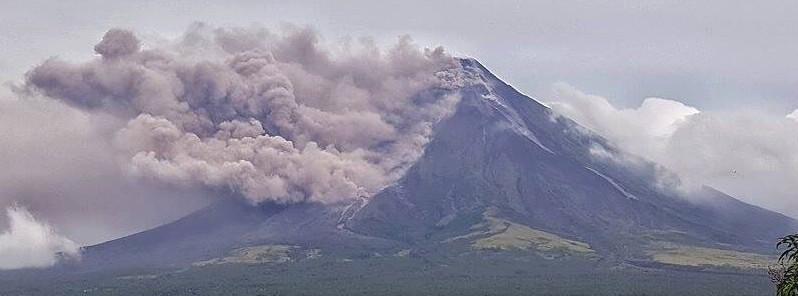
Lava flows were first observed on the southern slopes on January 14, followed by two lava collapse events producing rockfalls and pyroclastic density currents as well as degassing events which sent ash plumes SW and WSW of the volcano on January 15.
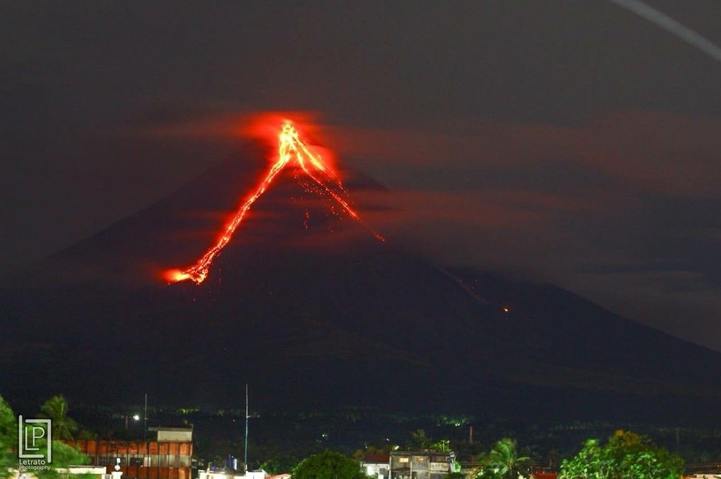
Mayon volcano lava flow January 15, 2018. Credit: Joshua Eric Velasco Dandal
Quiet lava effusion from the new summit lava dome and lava collapse event characterized its eruptive activity since January 15.
On January 18, 24 rockfall events and 1 volcanic earthquake were recorded by Mayon's seismic monitoring network.
Rockfall events were generated by the collapsing lava front and margins of the advancing lava flow on the Miisi Gully and by shedding from the summit dome onto the Bonga Gully. The Miisi lava flow has advanced to approximately 3 km (1.8 miles) from the summit crater well within the Permanent Danger Zone (PDZ). Ash clouds were lofted from the rockfall events as well as from the persistent disintegration of lava on the advancing front of the Miisi lava flow before drifting to the southwest.
Sulfur dioxide gas emission was measured at an average of 1 478 tonnes/day on January 18, 2018.
Similar activity was observed on January 19. Seismic network registered 5 rockfall events and the Missi lava flow was still 3 km from the summit crater.
Sulfur dioxide gas emission was measured at an average of 1 131 tonnes/day on January 19, 2018. Electronic tilt measurements indicate a sustained swelling or inflation of the edifice since November 2017, consistent with pressurization by magmatic intrusion.
Alert Level 3 remains in effect, which means that the volcano is still in a relatively high level of unrest and a hazardous eruption is still possible within weeks or even days.
The public is strongly advised to be vigilant and desist from entering the 6 kilometer-radius Permanent Danger Zone (PDZ) and the 7-km Extended Danger Zone (EDZ) on the southern flanks due to the danger of rockfalls, landslides and sudden explosions or dome collapse that may generate hazardous volcanic flows.
PHIVOLCS is also advising increased vigilance against pyroclastic density currents, lahars and sediment-laden streamflows along channels draining the edifice.
Civil aviation authorities must also advise pilots to avoid flying close to the volcano’s summit as ash from any sudden eruption can be hazardous to aircraft.
Based on the seasonal wind pattern, ash fall events may most likely occur on the southwest side of the volcano.
Geological summary
Beautifully symmetrical Mayon volcano, which rises to 2 462 m (8 077 feet) above the Albay Gulf, is the Philippines' most active volcano. The structurally simple volcano has steep upper slopes averaging 35-40 degrees that are capped by a small summit crater. Historical eruptions at this basaltic-andesitic volcano date back to 1616 and range from strombolian to basaltic plinian, with cyclical activity beginning with basaltic eruptions, followed by longer term andesitic lava flows.
Eruptions occur predominately from the central conduit and have also produced lava flows that travel far down the flanks. Pyroclastic flows and mudflows have commonly swept down many of the approximately 40 ravines that radiate from the summit and have often devastated populated lowland areas.
Mayon's most violent eruption, in 1814, killed more than 1200 people and devastated several towns. (GVP)
Featured image: Mayon volcano, Philippines on January 16, 2018.
Commenting rules and guidelines
We value the thoughts and opinions of our readers and welcome healthy discussions on our website. In order to maintain a respectful and positive community, we ask that all commenters follow these rules:
We reserve the right to remove any comments that violate these rules. By commenting on our website, you agree to abide by these guidelines. Thank you for helping to create a positive and welcoming environment for all.