Storm Eleanor to hit Ireland, UK and France with powerful winds, thundery rain
Winter Storm Eleanor is heading toward Ireland, United Kingdom and France today. Very severe and damaging gusts, heavy and locally thundery rain as well as very high seas are expected late Tuesday, January 2 into January 3, 2018.
Status Yellow wind and rain warnings are in effect across entire Ireland today while Status Orange Wind Warning is in effect for Munster, Leinster and Galway. Status Orange Gale Warning (Marine Warning) is also in effect as gale to storm force gale winds are expected on all coasts of Ireland and on the Irish Sea with a risk of violent storm force winds briefly on some western and eastern coasts and on parts of the North Irish Sea.
Eleanor will start moving over Ireland later this afternoon and move very quickly across the country this evening, Met Eireann warned. Southwest to west winds of mean speeds from 65 to 80 km/h (40 – 55 mph), gusting up to 110 and 130 km/h (70 – 80 mph) are expected along with very high sea along Atlantic coasts, with a risk of coastal flooding. Thundery downpours expected in places this afternoon and early evening with falls of 20 to 25 mm (0.8 – 1 inch) in some parts.
"The wind will pick up again later on Tuesday and Wednesday as developing Storm Eleanor heads towards the UK and Ireland," Paul Gundersen, Met Office Chief Forecaster, said. "National Severe Weather Warnings have been issued as there is the potential for some travel disruption, and high waves throwing beach material on to sea fronts, roads and coastal properties, along western and southern coasts," he said.
"Unsettled weather with strong winds and at times large waves, combined with high tides, could lead to some coastal flooding from Tuesday until Thursday," said Carol Holt, flood duty manager for the Environment Agency. "Our frontline teams are on the ground checking defenses and may close coastal floodgates this week."
"We urge people to stay safe on the coast – take extreme care on coastal paths and promenades, and don’t put yourself in unnecessary danger trying to take ‘storm selfies’. If you’re traveling, please check your route before setting off and don’t drive through flood water.
Here's a closer look at #StormEleanor during the next few hours #weatheraware pic.twitter.com/FPnwQHpWMF
— Met Office (@metoffice) January 2, 2018
The latest satellite picture shows a little #sunshine this afternoon, but circled in green is #StormEleanor pic.twitter.com/M88GnolkbU
— Met Office (@metoffice) January 2, 2018
21 départements en #VigilanceOrange aux vents forts (rafales > 120 km/h sur la côte, >100 km/h dans les terres) et aux vagues-submersion avec le passage de #StormEleanor à partir de cette nuit et pour demain. @meteofrance pic.twitter.com/2yRSFAYT1p
— Sébastien Léas (@SebastienLeas) January 2, 2018
Meteo France placed 21 departments on Orange Alert today as the country braces for the second winter storm within 24 hours. In addition, the Finistere coastline is on alert for particularly intense waves which may breach beach walls and other coastline barriers, and cause flooding.
Eleanor is expected to sweep the country on Tuesday, January 2 and Wednesday, January 3 with winds up to 120 km/h (74 mph) along the coast and 100 – 110 km/h (up to 70 mph) closer inland.
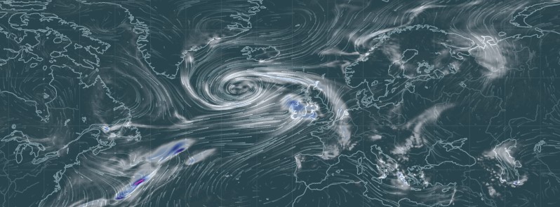
Featured image: Winter Storm Eleanor at 15:00 UTC on January 2, 2017. Credit: Earth.Nullschool.net
Commenting rules and guidelines
We value the thoughts and opinions of our readers and welcome healthy discussions on our website. In order to maintain a respectful and positive community, we ask that all commenters follow these rules:
We reserve the right to remove any comments that violate these rules. By commenting on our website, you agree to abide by these guidelines. Thank you for helping to create a positive and welcoming environment for all.