US and Canada: Extremely cold temperatures continue, list of broken records
Extremely cold, dangerous temperatures will continue across much of the United States and southern Canada into next week, with heavy wintry precipitation continuing across the Pacific Northwest and Northern Rockies into Saturday, December 30. This cold blast is both severe and unusually long, one of the sharpest New Year cold blasts on record. Numerous records were already broken and many new ones are expected before this ends.
Dangerously cold temperatures and wind chills will continue across the Northern/Central Plains, Great Lakes, and Northeast into early next week, NWS warns. Heavy mountain snow and freezing rain in some lower elevations will lead to dangerous travel conditions into Saturday, December 30 across the Pacific Northwest and northern Rockies. Meanwhile, heavy lake-effect snows are expected across the Great Lakes this weekend.
The dominating weather story as we head into the weekend continues to be the cold air mass persisting across much of the country east of the Rockies with afternoon high temperatures of 2.7 – 5.5 °C (5 to 10 °F) below normal, NWS said.
Meanwhile, a clipper type of system is expected to send a swath of light snow from the Midwest this evening, into the northern Mid-Atlantic on Saturday, December 30 with only light accumulations expected.
Across the Great Lakes, westerly flow on the backside of this system will allow for moderate to heavy lake effect snows to continue downwind of the lakes with localized totals of 15 to 30+ cm (6 to 12+ inches) possible.
In the wake of this cold front though, another reinforcing shot of very cold arctic air from Canada will drop into the northern Plains by Saturday. This will bring daytime high temperatures plunging to near or below zero readings this weekend, which is 16 – 22 °C (30 to 40 °F) below normal for this time of the year. This air mass will spread eastward on Sunday, December 31 with parts of the Northeast and Mid-Atlantic expected to be near 11 °C (20 °F) below average.
Out west, heavy snowfall will continue tonight and into Saturday across the northern Intermountain West and the northern Plains as upper-level energy moves through in the flow aloft.
Winter storm warnings and winter weather advisories are in effect with additional snowfall accumulations of 30 – 60 cm (1 to 2 feet) possible in the highest terrain. The heavy rainfall across coastal regions of the Pacific Northwest should come to an end this evening as the associated cold front moves onshore.
Looking ahead, the start of the new year will continue to favor below average temperatures across the eastern half of the country as several clipper systems bring reinforcing shots of Arctic air to the region.
The mornings of January 1 and 2, 2018, will feature temperature anomalies in the 16 – 19 °C (30 – 35 °F) below average range across the Northern Rockies eastward into the Northern Plains/Middle Mississippi Valley, according to the NWS.
"Despite ample sunshine expected during the daytime, little relief from the cold is expected given the persistent cold advection and low solar angle for early January. A number of daily temperature records will likely be broken from the Great Plains eastward, primarily for the cold maxima expected," NWS forecaster Brendon Rubin-Oster noted 16:06 today.
"This is particularly the case on New Years Day with single digits and teens expected along the I-95 corridor from New England down to the Mid-Atlantic while 20s are commonplace along the Red River and into the Lower Mississippi Valley. Out west, a persistent ridge with occasional Pacific influences should keep temperatures on the mild side with readings 5 – 8 °C (10 to 15 °F) above climatology over the Central Great Basin and Desert Southwest."
Meanwhile, the cyclonic flow across the Great Lakes should continue to keep lake-effect snow bands in play.
"Some of these Arctic surges will bring 700 hPa temperatures down into the -25 to -30 °C range which will significantly steepen lapse rates over any ice-free lake surfaces," Rubin-Oster noted.
List of notable records broken since December 25
Monday, January 1, 2018
-36.6 °C (-34 °F) was recorded in Sioux City, Iowa late December 31 into January 1, setting and new daily record low (for December 31 and January 1) and marking the city's coldest temperature since December 23, 1989.
According to Weather.com, the New Year's Day morning daily record lows include: -35 °C (-31 F) in Watertown, New York; -28.3 °C (-19 °F) in Des Moines, Iowa; -28.3 °C (-19 °F) in Moline, Illinois, -26.1 °C (-15 °F) in Syracuse, New York; -20 °C (-4 °F) Buffalo, New York; and -18.8 °C (-2 °F) Harrisburg, Pennsylvania (minus 2 degrees).
Numerous cities saw record-cold high temperatures on January 1. New York City recorded a high of -7.2 °C (19 °F), breaking the old record of -4.4 °C (24 °F) set in 1940. Chicago reached -17.2 °C (1 °F), breaking the old record of -15 °C (5 °F) set in 1969. Charleston, South Carolina registered -1.1 °C (34 °F), breaking the old record of -7.2 °C (45 °F) set in 2001. Portland, Maine recorded -12.2 °C (10 °F), breaking the old record of -10.5 °C (13 °F) set in 1967.
Sunday, December 31, 2017
Wausau, Wisconsin, set a new daily record-cold high temperature -20 °C (-4 °F) at minus 4 degrees, breaking the previous record of -3 °C (-19 °F) set in 1968.
Record lows were set in Huron, South Dakota (-32.7 °C (-27 °F)), Bangor, Maine (-31.1 °C (-24 °F)), and Flint, Michigan (-23.8 °C (-11 °F)). Record low was tied in Binghamton, New York at -19.4 °C (-3 °F).
Saturday, December 30, 2017
Glen Falls, New York registered -29.4 °C (-21 °F), for the third day in a row setting a new daily record low temperatures.
With -26.1 °C (-15 °F), Fargo, North Dakota registered the coldest high temperature since January 2004.
Friday, December 29, 2017
Daily record lows were set for the second day in a row Friday in Glens Falls, New York (-28.3 °C (-19 °F)), Watertown, New York (-17 °C (-27.2 °F)), and Augusta, Maine (-15 °C (-26.1 °F)), as well as New York's JFK and La Guardia airports (both -11.1 °C (12 °F)).
Also for the second day in a row, both JFK (-5 °C (23 °F)) and LaGuardia (-5.5 °C (22 °F)) set daily record-cold high temperatures Friday.
On the same day, Worcester, Massachusetts registered a high of -13 °C (8 °F), breaking the previous record.
Thursday, December 28, 2017
Boston, Massachusetts recorded -11.2 °C (12 °F), breaking the previous record of -7.7 °C (18 °F) set in 1924 (the average for this day is 3.3 °C / 38 °F). Worcester, MA measured -13.8 °C (7 °F), breaking the previous record of -9.4 °C (15 °F) set in 1976 (the average for this day is 0.5 °C (33 °F).
Hartford, Connecticut recorded -11.6 °C (11 °F), breaking the previous record of -7.7 °C (18 °F) set in 1924 (the average for this day is 2.2 °C / 36 °F).
Providence, Rhode Island registered -10 °C (14 °F), breaking the previous record of -6.1 °C (21 °F) set in 1976 (the average for this day is 3.8 °C / 39 °F).
Flint, Michigan set an all-time December record-low temperature of -27.7 °C (-18 °F), breaking the all-time December low of -25.5 °C (-14 °F) recorded on December 27, 2017.
Alpena, Michigan, recorded -28.3 °C (-19 °F), making it the second-coldest December temperature on record there.
In neighboring Canada,
Toronto, Ontario, registered -22 °C (-8 °F) without windchill factored in, breaking the previous daily low of -18.9 °C (-2 °F) set in 1960.
Muskoka Airport, Ontario, set a record low temperature of -36.4 °C (-34 °F), breaking the old record of -28.3 °C (-18.9 °F) set in 1963.
Montreal, Quebec, set a daily record low at -20.5 °C (-5 °F), breaking the old record of -19.5 °C (-3.1 °F) set in 1993.
Wednesday, December 27, 2017
On Wednesday, December 27, International Falls in Minnesota measured -36 °F (37.8 °C), breaking its previous daily record low of -32 °F (-35.5 °C).
Lincoln, Nebraska set its new daily record low at -17 °F (-27.2 °C) and Norfolk, also in Nebraska, at -15 °F (-26.1 °C).
Flint, Michigan set its all-time December low at -25.5 °C (-14 °F).
Tuesday, December 26, 2017
With a preliminary 157.9 cm (62.2 inches) of snow, Redfield, NY broke the Oswego County record for two-day snow total as of 17:47 EST on December 26 (22:47 UTC). The old record was 144.8 cm (57 inches) measured in Bennetts Bridge in February 2008.
On the same day, Detroit tied its daily record low of -4 °F (-20 °C) and Alpena, Michigan its daily record low of -16 °F (-26.6 °C).
Another 62.2 cm (24.5 inches) fell by Tuesday night on Erie, PA, bringing the total since December 23 to 159.7 cm (62.9 inches) and breaking the entire state of Pennsylvania 2-day total of 111.7 cm (44 inches), recorded on December 20 and 21, 1958. It also beat the 13-day record snowfall for Erie of 134.1 cm (52.8 inches) recorded from December 31, 1998 to January 12, 1999. Since the start of the month, the city saw more than 253 cm (99.6 inches) of snow, breaking its previous monthly record of 169.9 cm (66.9 inches) measured in December 1989. On average, Erie receives 257 cm (101 inches) of snow per year and 70.6 cm (27.8 inches) from December 1 – 31.
Monday, December 25, 2017
Erie, Pennsylvania hit the news this week after its all-time daily snowfall record got shattered on Monday, December 25, 2017. That day, a potent storm dumped 86.3 cm (34 inches) of snow at Erie Airport which is more than four times its previous record for December 25 – 20.5 cm (8.1 inches).
The amount also smashed the city's snowiest single day record of 50.8 cm (20 inches) recorded on December 11, 1956.
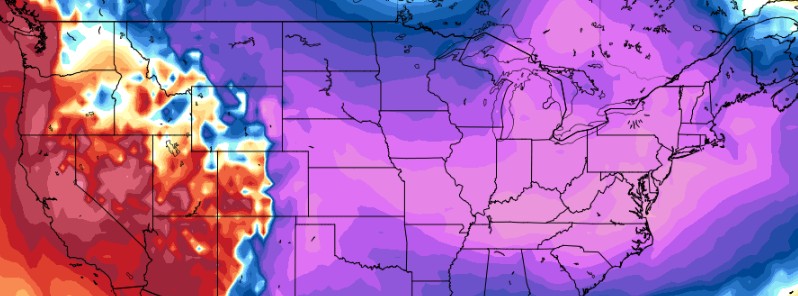
Featured image: 850 hPa temperature anomaly for January 1, 2017. Model run December 29, 2017 (12z). Credit: TropicalTidbits.com
It seems President Donald Trump has had the cause of these DEWs destroyed. I hope the heat visible in the NA-EFS around the US Rockies is eliminated by that. I have sent a query to WUWT about the extent of the Rocky Mountains’ High but am not confident of a reply.
Is it possible for you to tell us how long the phenomena lasted and if there are likely to be repercussions about such a long standing Blocked High?
Wee shoul look ar the residue of the Californian fires to see what residue in their debris provides clues about what additives pasted over the region provided a smoke-screen to the microwaves.
Wow, and this is the second warmest year ever!!!