Strong phreatic eruption at Mount Agung, Bali, Indonesia
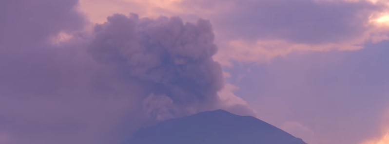
A strong phreatic eruption started at Mount Agung, Bali, Indonesia at 09:30 UTC (17:30 WIB) on Saturday, November 25, 2017. This is the second eruption of this volcano since Tuesday, November 21. Although significantly stronger, the Alert Level remains at second highest (III / standby) and the Aviation Color Code at Orange.
Today's eruption is more than twice as high as last Tuesday's. At 15:00 UTC, ash column was rising up to 6 km (20 000 feet) above sea level and drifting W/SW, according to the Darwin VAAC.
There have been no new evacuations, officials said and urged residents to remain calm and follow official updates.
Gunung Agung kembali erupsi pada 25/11/2017 pukul 17:30 WITA. Tinggi kolom abu erupsi 1.500 meter dari kawah. Status Siaga. Pengungsi 25.016 jiwa di 224 titik. Masyarakat tidak panik. @jokowi @raisa6690 @mynameisrossa @fadlizon @RadioElshinta @detikcom @kumparan @republikaonline pic.twitter.com/Y8BbYrMDqZ
— Sutopo Purwo Nugroho (@Sutopo_BNPB) November 25, 2017
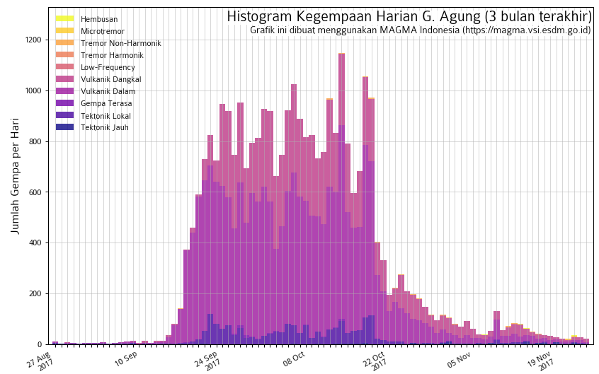
MAGMA Indonesia reported a small increase in volcanic earthquakes today. Seismic activity is characterized by low frequency earthquakes, Agung Volcano Observatory said.
"The alert level of the volcano has not been raised, it remains at level 3," said BNPB spokesman Sutopo Purwo Nugroho, adding, at 14:00 UTC, that Ngurah International Airport is still safe and that ash cloud is not affecting its flight paths.
However, several flights have already been canceled or diverted and people intending to travel to Bali and from Bali should check the airline's website.

Communities around Agung and climbers/visitors/tourists are asked not to approach the volcano and do not enter an area within a radius of 6 km (3.7 miles) from the crater and as far as 7.5 km (4.6 miles) to the NNE and SSW.
Mount Agung’s last major eruption was in 1963. It lasted for more than a year and is considered one of the world's largest eruptions of the 20th century. Nearly 1 600 people were killed.
Geological summary
Symmetrical Agung stratovolcano, Bali's highest and most sacred mountain, towers over the eastern end of the island. The volcano, whose name means " Paramount," rises above the SE caldera rim of neighboring Batur volcano, and the northern and southern flanks of Agung extend to the coast.
The 3142-m-high (10 308 feet) summit contains a steep-walled, 500-m-wide (1 640 feet), 200-m-deep (656 feet) crater. The flank cone Pawon is located low on the SE side.
Only a few eruptions dating back to the early 19th century have been recorded in historical time. The 1963-64 eruption, one of the world's largest of the 20th century, produced voluminous ashfall along with devastating pyroclastic flows and lahars that caused extensive damage and many fatalities.
Featured image: The eruption of Agung volcano on November 25, 2017. Credit: Alex Hope
Commenting rules and guidelines
We value the thoughts and opinions of our readers and welcome healthy discussions on our website. In order to maintain a respectful and positive community, we ask that all commenters follow these rules.