Severe storm sweeps through New Zealand, causing major power outages
A severe storm swept through New Zealand late Tuesday into Wednesday, November 8, 2017, leaving much of the South Island without power. Wind gusts reached 154 km/h (95 mph), maximum hourly rainfall 33 mm (1.29 inches) and snow was reported even at low elevations.
The storm front moved through the upper West Coast of the South Island, and to some extent the east coast down to North Canterbury between about midnight and 03:30 local time, hitting the region with powerful winds, heavy rain and snow.
The strongest wind gust was recorded in Wellington, with 154 km (95 mph) at Mt Kaukau at 05:00 NZDT, Wednesday. 115 km/h (71 mph) was recorded at Kelburn at 04:00 and 105 km/h (65 mph) at Wellington airport at 05:00.
Houses in the Monaco and Tahunanui areas of Nelson were flooded by the storm and sea surge, and a couple of houses in Nelson had their doors blown off, Fire and Emergency New Zealand (FENZ) spokesman Ian Littlejohn said.
A group of campers on a waterfront reserve area in the Mapua and Ruby Bay area were given help to evacuate. "When the storm surge came through the group decided they didn't feel safe enough to remain," Littlejohn said, as reported by Stuff. The water was at knee level in the area where the group had been camping.
Strong winds gradually easing, but still gusty through many eastern parts. Winds will continue to gradually ease through the day. ^TA pic.twitter.com/d6ceS6i6VO
— MetService (@MetService) November 8, 2017
Thanks to Adam Fleming for this shot of Kingston Otago under a morning coat of snow. ^TA pic.twitter.com/9SlZtKra3p
— MetService (@MetService) November 7, 2017
Snow in rural Te Anau – post your pics here or tag #metservicenz ^TA pic.twitter.com/U2BKUPJA2Z
— MetService (@MetService) November 7, 2017
Here are the stats so far on last night's severe weather. Still a band of intense rain for Auckland but otherwise things are easing now. ^TA pic.twitter.com/ZAUIQbgoqD
— MetService (@MetService) November 7, 2017
Power was out to much of the South Island Wednesday morning. "We have been hit reasonably hard in the western region," Powernet Otago said.
"The real story with this system is it's very short, sharp, intense in this overnight period, but things are easing off quickly for just about everybody. From this afternoon it's going to be fine with just moderate winds everywhere pretty much," MetService meteorologist Karl Loots said.
There are no reports of injuries.
Another potentially significant rainmaking event is expected to hit the upper North Island over the weekend.
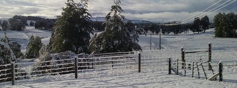
Featured image: Snow in Te Anau, New Zealand on November 8, 2017. Image credit: Antonia Croft, MetService
Commenting rules and guidelines
We value the thoughts and opinions of our readers and welcome healthy discussions on our website. In order to maintain a respectful and positive community, we ask that all commenters follow these rules:
We reserve the right to remove any comments that violate these rules. By commenting on our website, you agree to abide by these guidelines. Thank you for helping to create a positive and welcoming environment for all.