Alert level for Aoba (Ambae) volcano raised, Vanuatu
Volcanic activity at Aoba volcano, also known as Ambae, continues to increase, the Vanuatu Geohazards Observatory (VGO) reported September 6, 2017, and raised the Volcanic Alert Level for the volcano from Level 2 to Level 3 (on a scale of 0 – 4). This means that the volcano is in a minor eruption state.
At this Alert Level, the volcanic activity is likely to continue to increase or decrease to its normal level of unrest at any time. The area of risk is within 3 km (1.8 miles) around the volcano and areas that expose to trade winds.
With this situation, villages and communities of Ambae Island, especially those in the prevailing trade winds direction can expect volcanic gas, ash falls and acid rain that may cause foliage fumigation hence damage garden crops.
It’s very important that communities, villages, visitors and travel agencies seriously consider this information, VGO warns.
The Alert Level for Aoba was raised to 2 on August 21, 2016, signifying increased unrest. At the time, VGO reminded residents and tourists that hazardous areas were near and around the Manaro lakes.
The last known eruption of this volcano took place in 2011.
The Vanuatu Meteorology and Geohazards Department will continue to closely monitor the volcano. More information will be provided as soon as necessary.
Geological summary
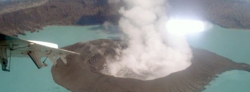
Aoba, also known as Ambae, is a massive 2 500 km3 (600 mi3) basaltic shield volcano that is the most voluminous volcano of the New Hebrides archipelago. A pronounced NE-SW-trending rift zone dotted with scoria cones gives the 16 x 38 km (10 x 23.6 miles) island an elongated form.
A broad pyroclastic cone containing three crater lakes is located at the summit of the Hawaiian-style shield volcano within the youngest of at least two nested calderas, the largest of which is 6 km (3.7 miles) in diameter. Post-caldera explosive eruptions formed the summit craters of Lake Voui (also spelled Vui) and Lake Manaro Ngoru about 360 years ago. A tuff cone was constructed within Lake Voui about 60 years later.
The latest known flank eruption, about 300 years ago, destroyed the population of the Nduindui area near the western coast. (GVP)
Featured image: Photo by Job Eassau, 2006 (courtesy of Esline Garaebiti, Dept of Geology, Mines, and Water Resources, Port Vila).
Commenting rules and guidelines
We value the thoughts and opinions of our readers and welcome healthy discussions on our website. In order to maintain a respectful and positive community, we ask that all commenters follow these rules.