Fernandina volcano enters new eruptive phase, first since 2009
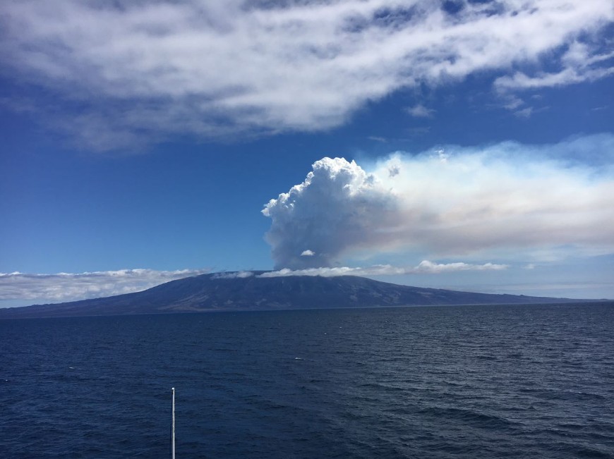
Ecuador's Fernandina volcano, the most active of Galápagos volcanoes, entered a new eruptive phase at approximately 17:25 UTC (12:25 local time) on September 4, 2017. The eruption comes after 8 years of superficial calm. It was observed by the crew of Lindblad Expeditions/National Geographic ship Endeavor II and confirmed by the personnel of the Galapagos Park. Fernandina is also known as La Cumbre.
According to Ecuador's Istituto Geofisico (IG), the seismic network installed in Galapagos began to detect activity around 14:55 UTC (09:55 local time).
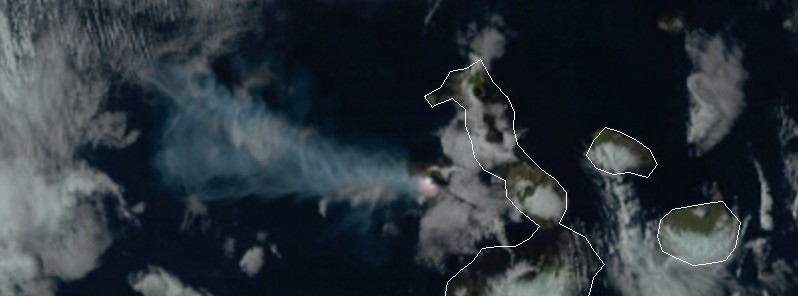
Satellite images acquired 19:28 UTC showed the presence of an eruptive column, which originated in the volcano and headed west to north-west at an altitude of approximately 4 000 m (13 123 feet) above the crater. This is approximately 5 476 m (17 965 feet) above sea level.
[VIDEO] Actividad eruptiva del volcán "La Cumbre" en Isla #Fernandina.#Galápagos pic.twitter.com/hJiGwEfumh
— Xavier A. Álvarez T. (@XaviAlvarezT) September 5, 2017
IG noted that Fernandina Island has no human settlements that could be affected by the eruption.
"Based on the direction of the wind, the eruption column is not expected to affect the populations of Puerto Ayora, Puerto Villamil, or Puerto Baquerizo, located south of the volcano," IG added.
Fernandina volcano eruption on September 4 as seen by NOAA GOES-16 satellite (preliminary and non-operational)
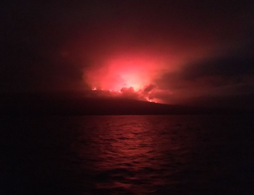
Fernandina volcano eruption – September 4, 2017. Credit: Galapagos Park
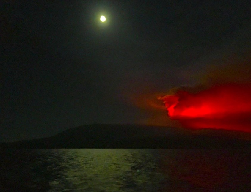
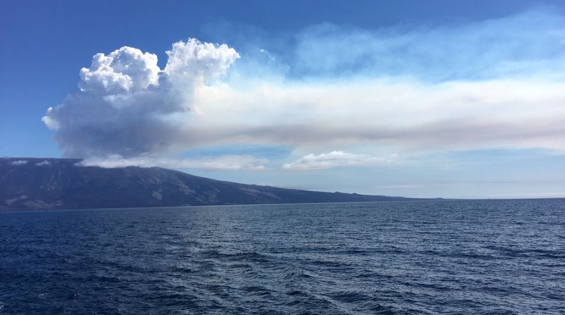
Fernandina volcano eruption – September 4, 2017. Credit: Galapagos Park
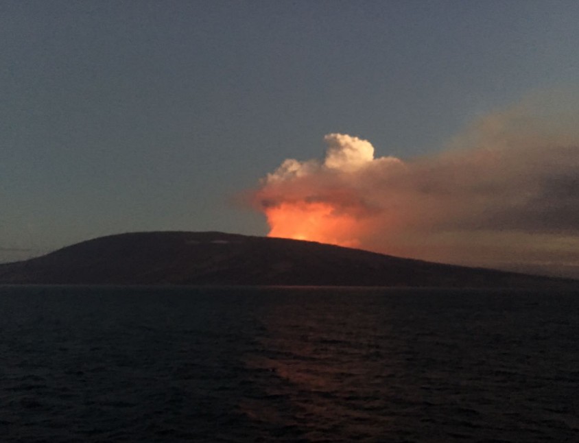
Fernandina volcano eruption – September 4, 2017. Credit: Galapagos Park
Fernandina volcano eruption – September 4, 2017. Credit: Galapagos Park
Fernandina volcano eruption – September 4, 2017. Credit: Galapagos Park
The last eruption of this volcano took place in 2009. Based on analysis of satellite imagery, IG reported that an eruption of Fernandina started sometime between 22:00 on April 10 and 00:30 local time on April 11, 2009. Several thermal anomalies were seen on satellite imagery, possibly indicating active lava flows. A representative of the Galápagos National Park reported that tourists and park employees observed the eruption during the early hours of April 11.
According to news articles, Galápagos National Park personnel conducting an overflight indicated that the eruption occurred from a fissure on the SW flank, about 500 m (1 640 feet) from the summit crater. The fissure was 200 m (656 feet) long and 10 m (32.8 feet) wide, and ejected lava fountains 15 m (49.2 feet) high. A gas-and-ash plume drifted SW. The eruption took place near the site of the previous eruption in 2005.
Based on analysis of satellite imagery, the Washington VVAC reported that during April 11 to 14 gas and possible ash plumes drifted up to 370 km (230 miles) W, SW, S, and N. On April 14, a large thermal anomaly and sulfur dioxide were detected. The observatory also reported smoke from burning vegetation.
Based on analysis of satellite imagery and information from IG, the Washington VVAC reported that during April 15 and 16 gas-and-steam plumes from Fernandina drifted up to 555 km (345 miles) W and a thermal anomaly was detected on the W half of the island. According to news articles, the eruption caused the deaths of numerous fish and multiple sea lions that were found floating in the sea.
According to a news article published in Antena 3, the eruption of Fernandina continued after about 20 days. Variable activity included steam-and-gas emissions and lava flows.
Geological summary
Fernandina, the most active of Galápagos volcanoes and the one closest to the Galápagos mantle plume, is a basaltic shield volcano with a deep 5 x 6.5 km (3.1 to 4 miles) summit caldera. The volcano displays the classic "overturned soup bowl" profile of Galápagos shield volcanoes.
Its caldera is elongated in a NW-SE direction and formed during several episodes of collapse. Circumferential fissures surround the caldera and were instrumental in the growth of the volcano. Reporting has been poor in this uninhabited western end of the archipelago, and even a 1981 eruption was not witnessed at the time.
In 1968 the caldera floor dropped 350 m (1 148 feet) following a major explosive eruption. Subsequent eruptions, mostly from vents located on or near the caldera boundary faults, have produced lava flows inside the caldera as well as those in 1995 that reached the coast from a SW-flank vent.
The collapse of a nearly 1 km3 (0.24 mi3) section of the east caldera wall during an eruption in 1988 produced a debris-avalanche deposit that covered much of the caldera floor and absorbed the caldera lake. (GVP)
Featured image: Fernandina volcano erupting at 22:15 UTC on September 4, 2017. Credit: NASA/GOES-16 (preliminary and non-operational)
Commenting rules and guidelines
We value the thoughts and opinions of our readers and welcome healthy discussions on our website. In order to maintain a respectful and positive community, we ask that all commenters follow these rules:
We reserve the right to remove any comments that violate these rules. By commenting on our website, you agree to abide by these guidelines. Thank you for helping to create a positive and welcoming environment for all.