Extremely dangerous Category 5 Hurricane “Irma” closing in on Leeward Islands
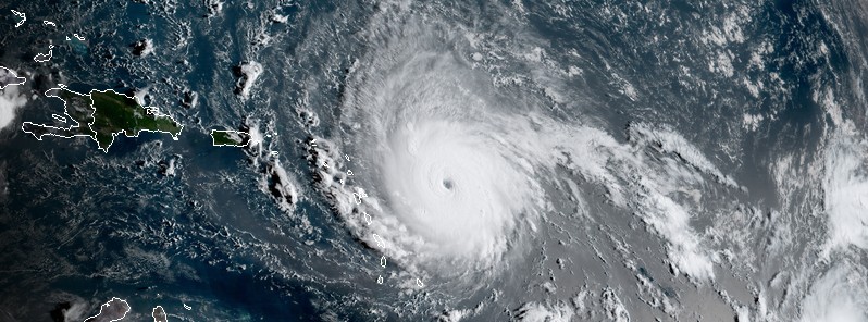
NOAA and Air Force hurricane hunter aircraft data indicate Hurricane "Irma" has intensified into an extremely dangerous Category 5 hurricane on the Saffir-Simpson Hurricane Wind Scale with maximum winds of 280 km/h (175 mph) with higher gusts. Irma is closing in on the Leeward Islands and is expected to pass over them tonight and early Wednesday, September 5 and 6, 2017. Irma is the strongest Atlantic Ocean hurricane since Felix in 2007.
This is an extremely dangerous hurricane. Preparations to protect life and property should be rushed to completion in the hurricane warning area.
- The combination of a dangerous storm surge and large breaking waves will raise water levels by as much as 1.8 to 2.7 m (6 to 9 feet) above normal tide levels along the coasts of the extreme northern Leeward Islands within the hurricane warning area near and to the
- north of the center of Irma. Near the coast, the surge will be accompanied by large and destructive waves.
- Irma is expected to produce total rainfall accumulations of 101.6 to 203.2 mm (4 to 8 inches) with isolated maximum amounts of 304. 8 mm (12 inches) across the northern Leeward Islands, the British and U.S. Virgin Islands, and Puerto Rico. These rainfall amounts may cause life-threatening flash floods and mudslides.
- Swells generated by Irma will affect the northern Leeward Islands, Puerto Rico, and the U.S. and British Virgin Islands during the next several days. These swells are likely to cause life-threatening surf and rip current conditions.
The strongest hurricane on record in satellite era (since 1966) to hit Leeward Islands is Hurricane "David" of 1979 at 257 km/h (160 mph) -> Irma is now at 280 km/h (175 mph). David was an extremely deadly hurricane which caused massive devastation and loss of life in the Dominican Republic in August of 1979.
A Cape Verde-type hurricane that reached Category 5 hurricane status on the Saffir-Simpson Hurricane Scale, David was the fourth named tropical cyclone, second hurricane, and first major hurricane of the 1979 Atlantic hurricane season, traversing through the Leeward Islands, Greater Antilles, and East Coast of the United States during late August and early September. David is believed to have been responsible for 2 068 deaths, making it one of the deadliest hurricanes of the modern era. It caused torrential damage across its path, most of which occurred in the Dominican Republic where the hurricane made landfall as a Category 5 hurricane.
As of 11:45 UTC (07:45 AST) on September 5, 2017, the distinct eye of Hurricane "Irma" was located 440 km (270 miles) E of Antigua and 445 km (280 miles) ESE of Barbuda. Its maximum sustained winds are now reaching 280 km/h (175 mph). Irma is moving W at 22 km/h (14 mph) with a minimum estimated central pressure of 929 hPa.
This general motion is expected to continue today, followed by a turn toward the west-northwest tonight. On the current NHC forecast track, the core of Hurricane "Irma" will move near or over portions of the northern Leeward Islands tonight and early Wednesday, September 5 and 6.
A Hurricane Warning is in effect for:
- Antigua, Barbuda, Anguilla, Montserrat, St. Kitts, and Nevis
- Saba, St. Eustatius, and Sint Maarten
- Saint Martin and Saint Barthelemy
- British Virgin Islands
- U.S. Virgin Islands
- Puerto Rico, Vieques, and Culebra
A Hurricane Warning means that hurricane conditions are expected somewhere within the warning area. A warning is typically issued 36 hours before the anticipated first occurrence of tropical-storm-force winds, conditions that make outside preparations difficult or dangerous. In this case, for some of the easternmost islands, the hurricane conditions are expected within the next 24 hours.
Preparations to protect life and property should be rushed to completion.
A Hurricane Watch is in effect for:
- Guadeloupe
- Dominican Republic from Cabo Engano to the northern border with Haiti
A Tropical Storm Warning is in effect for:
- Guadeloupe
- Dominica
A Tropical Storm Warning means that tropical storm conditions are expected somewhere within the warning area in this case within 36 hours. Interests in the Dominican Republic, Haiti, the Turks and Caicos Islands, Cuba, and the southeastern and central Bahamas should monitor the progress of Irma.
A Tropical Storm Watch is in effect for:
- Dominican Republic from south of Cabo Engao to Isla Saona
A Tropical Storm Watch means that tropical storm conditions are possible within the watch area, generally within 48 hours.
Hurricane conditions are expected within the hurricane warning area by tonight, with tropical storm conditions beginning later today.
Tropical storm conditions are expected within the tropical storm warning area where hurricane conditions are also possible.
Hazards affecting land
The combination of a dangerous storm surge and large breaking waves will raise water levels by as much as 6 to 9 feet above normal tide levels along the coasts of the extreme northern Leeward Islands within the hurricane warning area near and to the north of the center of Irma. Near the coast, the surge will be accompanied by large and destructive waves.
The combination of a dangerous storm surge and the tide will cause normally dry areas near the coast to be flooded by rising waters moving inland from the shoreline. The water is expected to reach the following heights above ground if the peak surge occurs at the time of high tide:
British and U.S. Virgin Islands except St. Croix: 1.2 to 1.8 m (4 to 6 feet)
Northern coast of Puerto Rico: 0.6 to 1.2 m (2 to 4 feet)
Southern coast of Puerto Rico and St. Croix: 0.3 to 0.6 m (1 to 2 feet)
The deepest water will occur along the immediate coast in areas of onshore winds, where the surge will be accompanied by large and destructive waves. Surge-related flooding depends on the relative timing of the surge and the tidal cycle, and can vary greatly over short distances.
Irma is expected to produce total rainfall accumulations of 101.6 to 203.2 mm (4 to 8 inches) with isolated maximum amounts of 304. 8 mm (12 inches) across the northern Leeward Islands, the British and U.S. Virgin Islands, and Puerto Rico. These rainfall amounts may cause life-threatening flash floods and mudslides.
Swells generated by Irma will affect the northern Leeward Islands, Puerto Rico, and the U.S. and British Virgin Islands during the next several days.
These swells are likely to cause life-threatening surf and rip current conditions.
Category 5 Hurricane "Irma" at 11:30 UTC on September 5, 2017. Credit: NOAA/GOES-16 (preliminary and non-operational)
According to Dr. Philip Klotzbach, meteorologist at CSU specializing in Atlantic basin seasonal hurricane forecasts, Irma is the 17th hurricane in the Antlantic to have maximum winds >= 280 km/h (175 mph). Atlantic Ocean's maximum wind record is held by Hurricane "Alen" of 1980 at 306 km/h (190 mph).
Irma is the strongest Atlantic Ocean hurricane since Felix in 2007.
As of September 5, Irma has been major hurricane for 3.5 days, trailing only Luis (1995) for Category 3+ hurricane days by TC in the tropical Atlantic (<20N, 20-60W) on record.
Irma is also the furthest east in Atlantic that we've had a 280 km/h (175 mph) hurricane on record (57.7°W). The previous record was held by David (1979) – (66.2°W).
The strongest hurricane on record in satellite era (since 1966) to hit Leeward Islands is David (1979) at 257 km/h (160 mph).
In satellite era, only 3 hurricanes have hit Leeward Islands at >= 241 km/h (150 mph).
Featured image: Category 5 Hurricane "Irma" at 11:30 UTC on September 5, 2017. Credit: NOAA/GOES-16 (preliminary and non-operational)
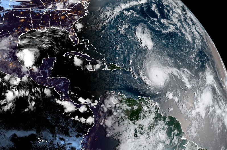
News reports suggest that as on 5 September 2017 , Atlantic hurricane IRMA seems to be roaming somewhere in northern Caribean. The opinion is that present is too early to say which place in US it may or may not make landfall. Gulf and East Coasts could be impacted. This Vedic astrology writer had indicated some States or major regions in US which may probably have alert for more care and appropriate strategy against “ hurricane like natural disasters” in August- September 2017. These alerts of September 2016 last in article – “ Astrological probable alerts for US in 2017” – were published last year in December 2016 in wisdom-magazine.com from US. Such like vulnerable regions or States in US as Miami , Maine, Missouri, Detroit , Tennessee or Texas were alerted through the article. On a later thinking , Dominican Republic was also included for alert about four months past from now against such natural disasters through a process of emails to numerous news media. So while readers can look for guidance in the said article , no certainty is claimed because human efforts and strategies meanwhile also play role and further that such conclusions can have probably error or slip.