Major M7.7 earthquake hits Aleutian Trench, tsunami advisories issued

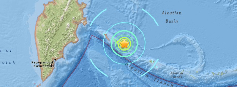
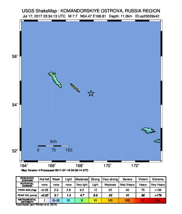
A major earthquake registered by the USGS as M7.7 hit near Komandorskiye Ostrova, Russia at 23:34 UTC on July 17, 2017. The agency is reporting a shallow depth of 11 km (6.8 miles.) This is the 4th earthquake in this area since M6.2 at 11:05 UTC today. It was followed by M5.2 at 23:49 UTC, M5.1 at 23:52, M5.2 at 23:57 UTC on July 17 and M5.3 at 00:26 UTC on July 18, according to the USGS.
GFZ Potsdam (GEOFON Program) is reporting the 23:34 UTC quake as M7.7 at a depth of 10 km (6.2 miles). For the 23:57 UTC quake, they initially reported another major earthquake measuring M8.0 (automatic, non-revised), and later downgraded it to M5.4. USGS reports that one as M5.2.
According to the USGS, the epicenter of today's M7.7 earthquake was located 335.5 km (208.5 miles) WNW of Attu (population 0), Alaska and 547.7 km (340.3 miles) ESE of Klyuchi (population 10 000), Russia.
There are no people living within 100 km (62 miles). However, based on all available data, hazardous tsunami waves are forecast for some coasts.
Animation courtesy JRC
A tsunami advisory is currently in effect for Aleutian Islands, Samalaga Pass, Alaska to Attu, Alaska including the Pribilof Islands, NTWC said.
BULLETIN Public Tsunami Message Number 1 NWS National Tsunami Warning Center Palmer AK 508 PM PDT Mon Jul 17 2017 ...A TSUNAMI ADVISORY IS NOW IN EFFECT... Tsunami Advisory in Effect for; * ALEUTIAN ISLANDS, Samalga Pass, Alaska (30 miles SW of Nikolski) to Attu, Alaska including the Pribilof Islands For other US and Canadian Pacific coasts in North America, the level of tsunami danger is being evaluated. Further information will be provided in supplementary messages. PRELIMINARY EARTHQUAKE PARAMETERS --------------------------------- * The following parameters are based on a rapid preliminary assessment and changes may occur. * Magnitude 7.8 - REVISED * Origin Time 1534 AKDT Jul 17 2017 1634 PDT Jul 17 2017 2334 UTC Jul 17 2017 * Coordinates 54.5 North 168.9 East * Depth 6 miles * Location 120 miles SE of Bering I., Komandorski 430 miles E of Petropavlovsk, Kamchatka FORECASTS OF TSUNAMI ACTIVITY ----------------------------- * Tsunami activity is forecasted to start at the following locations at the specified times. FORECAST START SITE OF TSUNAMI ---- ---------- * Alaska Shemya 1615 AKDT Jul 17 Adak 1720 AKDT Jul 17 Saint Paul 1830 AKDT Jul 17 OBSERVATIONS OF TSUNAMI ACTIVITY -------------------------------- * No tsunami observations are available to report. RECOMMENDED ACTIONS ------------------- Actions to protect human life and property will vary within tsunami advisory areas. If you are in a tsunami advisory area; * Move out of the water, off the beach, and away from harbors, marinas, breakwaters, bays and inlets. * Be alert to and follow instructions from your local emergency officials because they may have more detailed or specific information for your location. * If you feel a strong earthquake or extended ground rolling take immediate protective actions such as moving inland and/or uphill preferably by foot. * Boat operators, * Where time and conditions permit, move your boat out to sea to a depth of at least 180 feet. * If at sea avoid entering shallow water, harbors, marinas, bays, and inlets to avoid floating and submerged debris and strong currents. * Do not go to the shore to observe the tsunami. * Do not return to the coast until local emergency officials indicate it is safe to do so. IMPACTS ------- Impacts will vary at different locations in the advisory areas. If you are in a tsunami advisory area; * A tsunami with strong waves and currents is possible. * Waves and currents can drown or injure people who are in the water. * Currents at beaches and in harbors, marinas, bays, and inlets may be especially dangerous. * Some impacts may continue for many hours to days after arrival of the first wave. * The first wave may not be the largest so later waves may be larger. * Each wave may last 5 to 45 minutes as a wave encroaches and recedes. * Coasts facing all directions are threatened because the waves can wrap around islands and headlands and into bays. * Strong shaking or rolling of the ground indicates an earthquake has occurred and a tsunami may be imminent. * A rapidly receding or receded shoreline, unusual waves and sounds, and strong currents are signs of a tsunami. * The tsunami may appear as water moving rapidly out to sea, a gentle rising tide like flood with no breaking wave, as a series of breaking waves, or a frothy wall of water. ADDITIONAL INFORMATION AND NEXT UPDATE -------------------------------------- * Refer to the internet site tsunami.gov for more information. * Pacific coastal residents outside California, Oregon, Washington, British Columbia and Alaska should refer to the Pacific Tsunami Warning Center messages at tsunami.gov. * This message will be updated within 60 minutes. $$
According to PTWC's Tsunami Threat Message issued 00:14 UTC on July 18, tsunami waves are forecast to be less than 0.3 m (0.98 feet) above the tide level for the coasts of Guam, Hawaii, Japan, Johnston Atoll, Marshall Islands, Midway Island; Northern Marianas, Northwestern Hawaiian Islands, Russia, Wake Island, and Yap.
Full message follows:
TSUNAMI MESSAGE NUMBER 2 NWS PACIFIC TSUNAMI WARNING CENTER EWA BEACH HI 0014 UTC TUE JUL 18 2017 ...PTWC TSUNAMI THREAT MESSAGE... **** NOTICE **** NOTICE **** NOTICE **** NOTICE **** NOTICE ***** THIS MESSAGE IS ISSUED FOR INFORMATION ONLY IN SUPPORT OF THE UNESCO/IOC PACIFIC TSUNAMI WARNING AND MITIGATION SYSTEM AND IS MEANT FOR NATIONAL AUTHORITIES IN EACH COUNTRY OF THAT SYSTEM. NATIONAL AUTHORITIES WILL DETERMINE THE APPROPRIATE LEVEL OF ALERT FOR EACH COUNTRY AND MAY ISSUE ADDITIONAL OR MORE REFINED INFORMATION. **** NOTICE **** NOTICE **** NOTICE **** NOTICE **** NOTICE ***** THE TSUNAMI FORECAST IS UPDATED IN THIS MESSAGE. NOTE REVISED EARTHQUAKE MAGNITUDE IS 7.8 PRELIMINARY EARTHQUAKE PARAMETERS --------------------------------- * MAGNITUDE 7.8 * ORIGIN TIME 2334 UTC JUL 17 2017 * COORDINATES 54.5 NORTH 168.9 EAST * DEPTH 10 KM / 6 MILES * LOCATION KOMANDORSKIYE OSTROVA RUSSIA REGION EVALUATION ---------- * AN EARTHQUAKE WITH A PRELIMINARY MAGNITUDE OF 7.8 OCCURRED IN THE KOMANDORSKIYE OSTROVA, RUSSIA REGION AT 2334 UTC ON MONDAY JULY 17 2017. * BASED ON ALL AVAILABLE DATA... HAZARDOUS TSUNAMI WAVES ARE FORECAST FOR SOME COASTS. TSUNAMI THREAT FORECAST...UPDATED --------------------------------- * TSUNAMI WAVES ARE FORECAST TO BE LESS THAN 0.3 METERS ABOVE THE TIDE LEVEL FOR THE COASTS OF GUAM... HAWAII... JAPAN... JOHNSTON ATOLL... MARSHALL ISLANDS... MIDWAY ISLAND... NORTHERN MARIANAS... NORTHWESTERN HAWAIIAN ISLANDS... RUSSIA... WAKE ISLAND... AND YAP. * ACTUAL AMPLITUDES AT THE COAST MAY VARY FROM FORECAST AMPLITUDES DUE TO UNCERTAINTIES IN THE FORECAST AND LOCAL FEATURES. IN PARTICULAR MAXIMUM TSUNAMI AMPLITUDES ON ATOLLS AND AT LOCATIONS WITH FRINGING OR BARRIER REEFS WILL LIKELY BE MUCH SMALLER THAN THE FORECAST INDICATES. * FOR OTHER AREAS COVERED BY THIS PRODUCT A FORECAST HAS NOT YET BEEN COMPUTED. THE FORECAST WILL BE EXPANDED IF NECESSARY IN SUBSEQUENT PRODUCTS. RECOMMENDED ACTIONS ------------------- * GOVERNMENT AGENCIES RESPONSIBLE FOR THREATENED COASTAL AREAS SHOULD TAKE ACTION TO INFORM AND INSTRUCT ANY COASTAL POPULATIONS AT RISK IN ACCORDANCE WITH THEIR OWN EVALUATION... PROCEDURES AND THE LEVEL OF THREAT. * PERSONS LOCATED IN THREATENED COASTAL AREAS SHOULD STAY ALERT FOR INFORMATION AND FOLLOW INSTRUCTIONS FROM NATIONAL AND LOCAL AUTHORITIES. POTENTIAL IMPACTS ----------------- * A TSUNAMI IS A SERIES OF WAVES. THE TIME BETWEEN WAVE CRESTS CAN VARY FROM 5 MINUTES TO AN HOUR. THE HAZARD MAY PERSIST FOR MANY HOURS OR LONGER AFTER THE INITIAL WAVE. * IMPACTS CAN VARY SIGNIFICANTLY FROM ONE SECTION OF COAST TO THE NEXT DUE TO LOCAL BATHYMETRY AND THE SHAPE AND ELEVATION OF THE SHORELINE. * IMPACTS CAN ALSO VARY DEPENDING UPON THE STATE OF THE TIDE AT THE TIME OF THE MAXIMUM TSUNAMI WAVES. * PERSONS CAUGHT IN THE WATER OF A TSUNAMI MAY DROWN... BE CRUSHED BY DEBRIS IN THE WATER... OR BE SWEPT OUT TO SEA. NEXT UPDATE AND ADDITIONAL INFORMATION -------------------------------------- * THE NEXT MESSAGE WILL BE ISSUED IN ONE HOUR... OR SOONER IF THE SITUATION WARRANTS. * AUTHORITATIVE INFORMATION ABOUT THE EARTHQUAKE FROM THE U.S. GEOLOGICAL SURVEY CAN BE FOUND ON THE INTERNET AT EARTHQUAKE.USGS.GOV/EARTHQUAKES -ALL LOWER CASE-. * FURTHER INFORMATION ABOUT THIS EVENT MAY BE FOUND AT PTWC.WEATHER.GOV AND AT WWW.TSUNAMI.GOV. * COASTAL REGIONS OF HAWAII... AMERICAN SAMOA... GUAM... AND CNMI SHOULD REFER TO PACIFIC TSUNAMI WARNING CENTER MESSAGES SPECIFICALLY FOR THOSE PLACES THAT CAN BE FOUND AT PTWC.WEATHER.GOV. * COASTAL REGIONS OF CALIFORNIA... OREGON... WASHINGTON... BRITISH COLUMBIA AND ALASKA SHOULD ONLY REFER TO U.S. NATIONAL TSUNAMI WARNING CENTER MESSAGES THAT CAN BE FOUND AT NTWC.ARH.NOAA.GOV. $$
At 01:00 UTC, PTWC issued their FInal Tsunami Threat Message, saying that the tsunami threat from this earthquake has now passed.
According to TASS, Russian News Agency, the Kamchatka crisis management center of the Russian Ministry for Emergency Situations said the tsunami wave forecasted at 50 cm (19.7 inches) in height has failed to approach Kamchatka's Bering Island. Teams of specialists are examining buildings after major aftershocks, but no destruction has been fixed as of yet.
Meanwhile, according to the head of Kamchatka’s Aleutian district, Svetlana Arnatskaya, strong tremors were felt. "Suspended items were swinging back and forth, items were tumbling off shelves. There has been no destruction," she said, adding that teams of specialists continue examining the area for possible destruction.
The map below shows all earthquakes in this region registered by the USGS between 11:05 UTC on July 17 and 00:26 UTC on July 18.
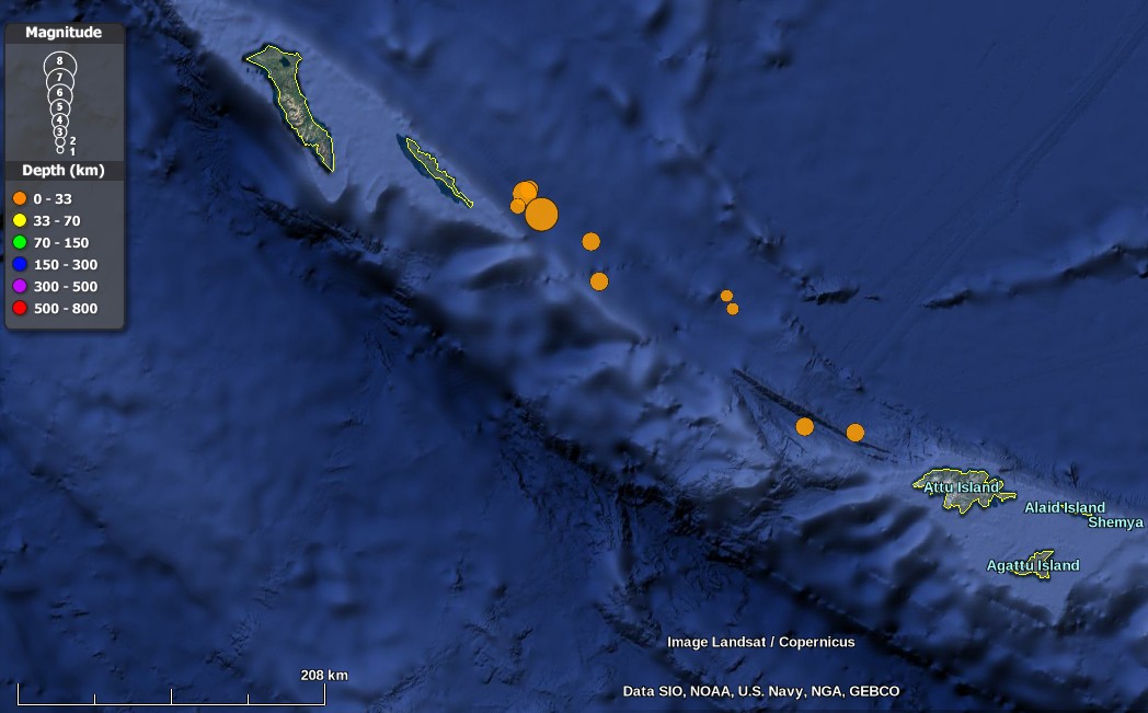
Credit: USGS, Landsat/Copernicus, Google
-
5.3
252km ESE of Nikol'skoye, Russia
2017-07-18 00:26:24 (UTC)
-
5.2
127km WNW of Attu Station, Alaska
2017-07-17 23:57:43 (UTC)
-
5.1
95km WNW of Attu Station, Alaska
2017-07-17 23:52:49 (UTC)
-
5.2
235km ESE of Nikol'skoye, Russia
2017-07-17 23:49:29 (UTC)
-
7.7
199km ESE of Nikol'skoye, Russia
2017-07-17 23:34:14 (UTC)
-
4.4
183km ESE of Nikol'skoye, Russia
2017-07-17 13:19:45 (UTC)
-
5.1
185km ESE of Nikol'skoye, Russia
2017-07-17 11:23:01 (UTC)
-
6.2
183km ESE of Nikol'skoye, Russia
2017-07-17 11:05:08 (UTC)
Tectonic summary
The July 17, 2017 M7.7 earthquake ESE of Nikol'skoye, Russia occurred as the result of transform faulting on or near the plate boundary between the Pacific and North America plates in the Northwest Pacific Ocean. The focal mechanism solution of the event indicates the earthquake occurred either on a right lateral fault oriented NW-SE, or on a left lateral fault striking NE.
At the location of the earthquake, the Pacific plate moves towards the NW at a rate of ~73 mm/yr with respect to North America, effectively moving horizontally past the North America plate at this the western extent of the Aleutian Trench. Along the arcuate Aleutian Trench, the motion of the Pacific Plate with respect to the North America Plate changes from almost purely convergent near south-central Alaska, to almost purely translational in the western most Aleutians where the Aleutian Trench meets the Kamchatka Trench. The location, depth, and focal mechanism solution of the earthquake are consistent with rupture on the main plate boundary, as right lateral faulting.
While commonly plotted as points on maps, earthquakes of this size are more appropriately described as slip over a larger fault area. Strike-slip-faulting events of the size of the July 17, 2017 earthquake are typically about 170×20 km (length x width).
The Aleutian Trench is seismically active, and the region within 250 km of the July 17, 2017 event has experienced 14 M6.5 and larger earthquakes since 1900. The largest event was a M7.8 earthquake that occurred December 17, 1929, approximately 200 km to the ESE of today's earthquake. The July 17, 2017 earthquake was preceded by a M6.2 foreshock roughly 12 hours earlier, and 15 km to the NE. In the 2.5 hours since the M7.7 mainshock, 10 M4.4+ aftershocks have been recorded. (USGS)
Featured image credit: USGS
If you value what we do here, create your ad-free account and support our journalism.
Your support makes a difference
Dear valued reader,
We hope that our website has been a valuable resource for you.
The reality is that it takes a lot of time, effort, and resources to maintain and grow this website. We rely on the support of readers like you to keep providing high-quality content.
If you have found our website to be helpful, please consider making a contribution to help us continue to bring you the information you need. Your support means the world to us and helps us to keep doing what we love.
Support us by choosing your support level – Silver, Gold or Platinum. Other support options include Patreon pledges and sending us a one-off payment using PayPal.
Thank you for your consideration. Your support is greatly appreciated.
Sincerely,
Teo Blašković
Commenting rules and guidelines
We value the thoughts and opinions of our readers and welcome healthy discussions on our website. In order to maintain a respectful and positive community, we ask that all commenters follow these rules:
We reserve the right to remove any comments that violate these rules. By commenting on our website, you agree to abide by these guidelines. Thank you for helping to create a positive and welcoming environment for all.