Fast-moving storm hits Twin Cities, leaving 132 00 homes without power, Minnesota
A fast-moving thunderstorm started in the Dakotas overnight Sunday, June 11, 2017 and pushed east into central Minnesota, dumping heavy rain and up to tennis-ball-sized hail.
The front edge of the storm system hit Twin Cities metro with wind gusts up to 112 km/h (70 mph), downing trees and power lines. "Cars and homes were hit with debris, and authorities reported fires believed to be caused by lightning strikes," CBS reported. "Streets in many communities were flooded with rainwater. In several places, mounds of hail could be seen floating on the floodwaters like small icebergs. In Coon Rapids, so much hail fell that streets had to be plowed."
The storm initially affected 132 000 households, mostly in the Twin Cities metro and St Cloud areas. Xcel Energy said it sent more than 500 people to repair outages, adding that by mid-day 45 000 households had their power restored. Around 34 000 were still without power Sunday night, when Xcel said that some of them might be without power for multiple days.
Meteorologist Mike Augustyniak said the storm could likely have caused more than $100 million worth of damage in the Twin Cities alone.
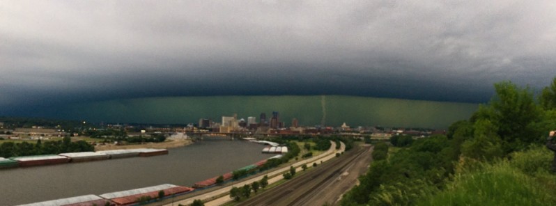
Watched this morning's storm roll in from from Dayton's Bluff @NWSTwinCities #mnwx pic.twitter.com/IKwupaYZ8V
— Melissa Dye (@M_DyeWx) June 11, 2017
The view from above as a thunderstorm complex producing gusts to 70+ mph moves across Minnesota. Data is preliminary, non-operational. #MNwx pic.twitter.com/yvJomk7Sfv
— NWS Duluth (@NWSduluth) June 11, 2017
This is what today's #storm looked like @mspairport #minneapolis #twincities #delta @delta #greensky pic.twitter.com/ss9OumJGEJ
— Greg Kjos (@Kjosy) June 11, 2017
Wind, rain, hail in St. Paul #mnwx pic.twitter.com/pznO23T3Uk
— Tim Post (@TimPostmanPost) June 11, 2017
A thick layer of hail slammed Coon Rapids this morning, one of many #TwinCities suburbs hit hard by storms. Watch my report at 5PM @kare11. pic.twitter.com/Ki6sWbIYDm
— Ivory Hecker (@IvoryHecker) June 11, 2017
Featured image: Fast-moving storm hits Twin Cities metro area, Minnesota on June 11, 2017. Credit: Melissa Dye
Commenting rules and guidelines
We value the thoughts and opinions of our readers and welcome healthy discussions on our website. In order to maintain a respectful and positive community, we ask that all commenters follow these rules:
We reserve the right to remove any comments that violate these rules. By commenting on our website, you agree to abide by these guidelines. Thank you for helping to create a positive and welcoming environment for all.