From drought to deluge, preparing for weeks of Katrina-style flooding
California has spectacularly emerged from one of its driest periods on record and ended its five-year drought by enduring one of its wettest periods on record. Its reservoirs, lakes, and mountainsides are now brimming with water and snow, though scientists caution that underground aquifers are a long way from having the same bounty that is visible on the land surface. Meanwhile, due to abnormally large amounts of snow in Sierra Nevada, nearby communities are preparing for weeks of potential Katrina-style flooding.
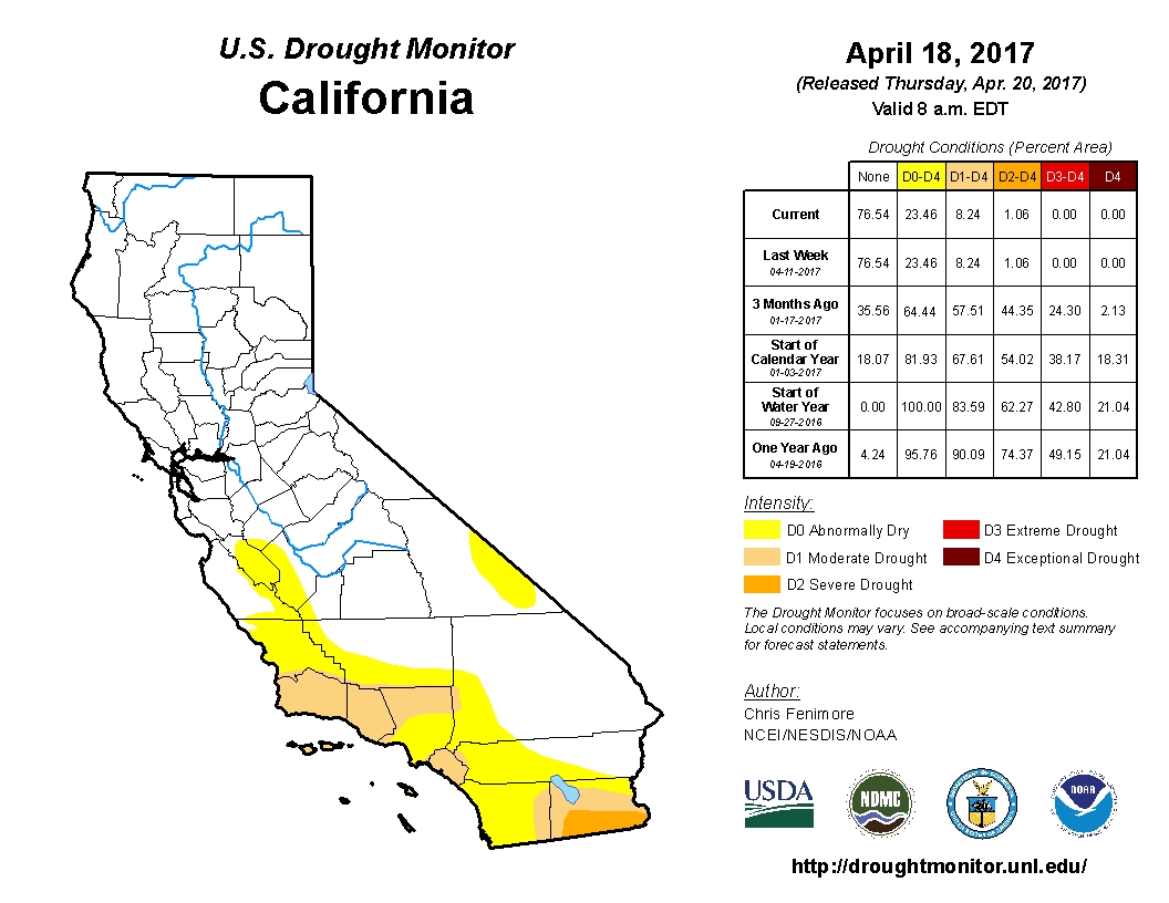
Between October 2016 and April 2017, California saw a 175% of the long-term average of rain, courtesy of numerous atmospheric river events. For both scientists and public, this was an unexpected turn of events which led the state to end the official drought emergency in all but four of its counties. As of April 18, just 18% of California was in some form of drought and 23%, almost entirely in southern California, was abnormally dry. As recently as December 27, 2016, the Drought Monitor reported 82% of the state in some measure of drought.
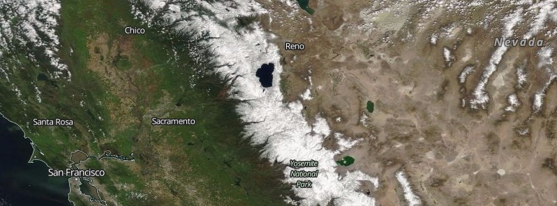
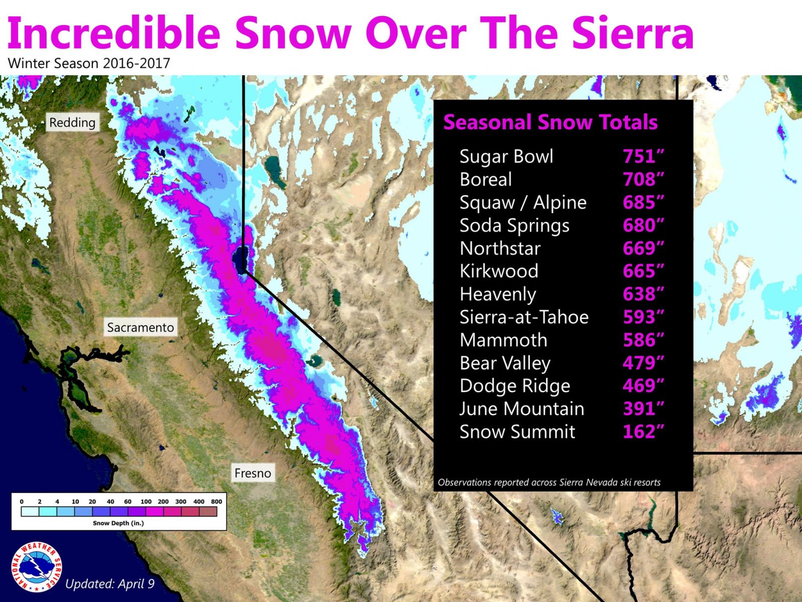
With more than five months still to go, California's northern Sierra Nevada has already achieved its wettest water year in recorded history, the National Weather Service office in Sacramento announced earlier this month. The mountains saw an incredible amount of snow this season, with a number of stations recording over 16.2 m (638 inches). As of Thursday, April 13, 2017, the Northern Sierra 8-Station Index has surpassed the mark for the wettest water year (October 1 – September 30) on record with 2.28 m (89.7 inches), the office said. The previous water year record was 2.23 m (88.5 inches) set in 1992 – 1983.
Sierra snowpack bigger than last 4 years combined
New NASA data show that snowpack in the Tuolumne River Basin in California's Sierra Nevada, a major source of water for San Francisco and California's Central Valley, is currently larger than the four previous years of snowpack combined. NASA's Airborne Snow Observatory (ASO) measured the Tuolumne Basin snowpack on April 1, a critical annual measurement of snow for states and their inhabitants, at 1.5 cubic km (1.2 million acre-feet), JPL said.
"In such a huge snow season, the data available from ASO will provide critical guidance for water managers as we enter into the peak melt season later this spring," Frank Gehrke, chief of the California Cooperative Snow Surveys of California's Department of Water Resources, said.
The 2017 California snowpack is close to the largest on the record, which consists of decades' worth of snow measurements made at ground level. ASO mapping showed that Tuolumne Basin's snowpack is twice the volume of last year's snowpack and 21 times larger than the snowpack of 2015, the lowest on record. The combined April 1 snow water equivalent of 2013 through 2016, years when California was in an intense drought, added up to only 92% of this year's April 1 measurement. In much of the Central Sierra, snow lies 8 m (25 feet) deep. In some high mountain basins, it's deeper than 24 meters (80 feet). And since April 1, it has continued to snow.
In the San Joaquin River Basin in California's Central Valley, this year's April 1 snow water equivalent was about 3.6 cubic km (2.9 million acre-feet). "This is a critical path to better water management for the San Joaquin River and Friant Dam, particularly in a year like this one, where annual inflow from snowmelt might be 10 times the operating capacity of our reservoir," Jeff Payne, water resources director for Friant, said.
Snow water equivalent – the water content of snow – in the Tuolumne River Basin in 2015 and 2017. Lighter blue indicates less snow, deeper blue is more snow (see the color bar at left). The 2017 snow water equivalent was 21 times greater than 2015, which was the lowest snowpack on record. Credit: NASA
Preparing for weeks of Katrina-style flooding
Such huge amounts of snow in the mountains are now posing a serious flooding threat and nearby communities are preparing for potential disasters when huge snowpack starts to melt. According to Reno Gazette-Journal, Nevada could see weeks of Katrina-style flooding when warm spring and summer sunshine melts the massive snowpack blanketing the Sierra Nevada.
That’s according to the Nevada National Guard and other emergency planners and responders who briefed Gov. Brian Sandoval on potential disaster scenarios. “Typically, Nevada experiences flash flooding,” Col. Cory Schulz told Sandoval, referencing hurricane flooding in 2005 that devastated New Orleans and southern Mississippi. “This will be saturation flooding, much like Katrina.”
The state has already endured two flood situations that triggered federal disaster declarations in February and March for western and northern parts of the state. Nearly three months later the Sierra snowpack has grown to record levels in some places and communities in the Carson and Walker river basins are at risk. The melting rate is expected to quicken as the weather warms in May and rivers could be at high levels deep into summer.
“Obviously, we are in the midst of … one of the three greatest water events in the history of Nevada,” Sandoval said. “We could get a warm rainstorm and it might get down faster than we would like.”
California water storage at 112% of the long-term average
The California Department of Water Resources, which tracks 46 major reservoirs, reported on April 18, 2017, that water storage stood at 112% of the long-term average for the entire system.
These six satellite images show key reservoirs in California near their lowest and highest points over the past three years. All images were acquired by the Operational Land Imager (OLI) on Landsat 8. The image pairs were chosen to match seasons and to avoid cloud cover over each scene. Tan bands around the shorelines (left image in each pair) are sands and sediments that were exposed as water levels dropped and the lake bottom became exposed.
The images below show Trinity Lake, the third largest reservoir in the state (after Lake Oroville and Shasta Lake). The artificial lake in northern California connects to the Trinity River and is part of the Sacramento basin. On April 29, 2015, Trinity stood at 59% of its historical average level for that date; by April 2, 2017, it stood at 114%. As of April 19, the lake was filled to 95% of its 2.45 million acre-foot capacity (and 117% of average water levels).
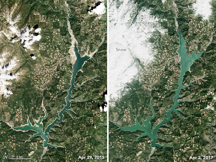
Trinity Lake – images acquired on April 29, 2015 and April 2, 2017. Credit: NASA/EO
Don Pedro Reservoir, California’s sixth largest, stands in the foothills of the Sierra Nevada and connects to the Tuolumne River and the San Joaquin Valley Basin. It is just miles from New Melones Lake, which is visible in the downloadable large image. When Landsat 8 acquired an image on February 26, 2015, the reservoir stood at 61% of its long-term average level. By March 3, 2017, it had risen to 134% of average.
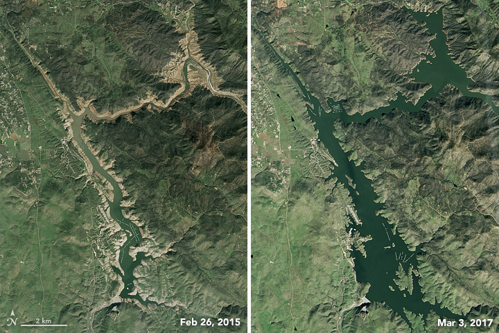
Don Pedro – images acquired on February 26, 2015 and March 3, 2017. Credit: NASA/EO
The third image pair shows Castaic Lake, which is the 24th largest reservoir in California but the largest water storage in the Los Angeles area. It stood at just 42% of average water levels on February 11, 2015; by February 1, 2017, it was back up to 98%.
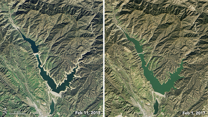
Castaic Lake – images acquired February 26, 2015 and March 3, 2017
“Reservoirs at the surface are only a partial measure of California’s water health,” cautioned Bill Patzert, a climatologist at NASA’s Jet Propulsion Laboratory. “From space, it looks like we are out of five years of punishing drought. But the depleted aquifers, 100 million dead trees, and $1 billion in flood damage will take decades to deal with.”
“Drought or deluge, we use more water than we have, and California suffers from chronic water scarcity,” said Jay Famiglietti, a hydrologist from JPL and the University of California-Irvine who leads the applied research effort. “That’s because California grows virtually all of the produce for the United States, as well as a tremendous amount of dairy. That level of productivity simply requires more water than is available on an annual renewable basis (snowmelt, rivers, and reservoirs). The water shortfall comes from groundwater, and that groundwater has been in decline for nearly a century. This winter will provide a slight replenishment bump, but that’s it.”
Drought monitor
California
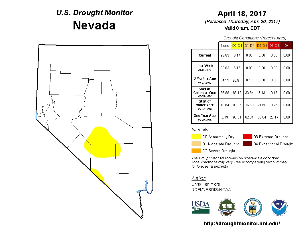
Nevada
A year ago, 93% of Nevada was in some state of drought while today such conditions are present in just 6% of the state.
Featured image credit: NASA/NOAA Suomi NPP/VIIRS. Acquired: April 14, 2017
Commenting rules and guidelines
We value the thoughts and opinions of our readers and welcome healthy discussions on our website. In order to maintain a respectful and positive community, we ask that all commenters follow these rules:
We reserve the right to remove any comments that violate these rules. By commenting on our website, you agree to abide by these guidelines. Thank you for helping to create a positive and welcoming environment for all.