Long duration ice storm continues in central US, death toll rising
Widespread freezing rain produced by Winter Storm "Jupiter" persists for much of western Oklahoma, Kansas, northern Missouri, and western Iowa. Continuing snow is forecast to the north of the freezing rain, and to the south, heavy rain and the potential for severe thunderstorms. As of late Sunday, January 15, 2017, the death toll has risen to 6. Tens of thousands have already lost power and there is a potential millions could be affected by power outages.
A significant winter storm system hit much of the central US this weekend and will continue through Monday, January 17, the National Weather Service said. More than 30 million Americans are under some type of wintry watch, and 10 million of those are under an ice storm warning.
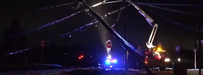
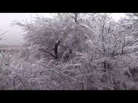
The hardest-hit states are Oklahoma, Kansas and Missouri with up to 2.5 cm (1 inch) of ice coating trees, power lines and roads. There is a potential millions of residents will lose power.
The weather service also issued a tornado watch for large parts of Texas and a tornado warning for just west of Waco. At least one tornado has touched down in central Texas, the service confirmed. Their spokesman said damage was reported Sunday evening in the Bosque County town of Clifton, about 100 km (62 miles) southwest of Forth Worth, and east of Lake Whitney, but it's unclear if both areas were hit by the same tornado. No injuries have been reported.
As of late Sunday, January 15, Jupiter was blamed for the deaths of at least six people. Two deaths occurred in separate accidents in Kansas, three in Missouri and one in Oklahoma. All of them died on roads.
A weather-related crash involving two semi trucks happened south of Odessa, Nebraska and closed both directions of I-80 Sunday morning. Nebraska state Patrol said that there were no injuries. I-80 was opened reopened about noon Sunday, but officials warned drivers to be extremely careful on the icy roads.
NWS meteorologist Cathy Zapotocny said that an ice storm of this magnitude hasn't hit Nebraska in 11 years.
Just West of Kearney on I-80 about an hour ago.
Learn from their misfortune.#StayHomeDontCrash #IceStormJupiter
(Pic by @rustywx) pic.twitter.com/dtIs62994d
— Ashland Fire Dept. (@AshlandFireDept) January 15, 2017
Freezing rain contributed to many more accidents across the region since Friday, January 13.


NWS warned that widespread freezing rain will persist for much of western Oklahoma, Kansas, northern Missouri and western Iowa Sunday night as warm advection aloft overrides sub-freezing temperatures at the surface. Ice storm warnings, freezing rain advisories, winter storm warnings and winter weather advisories in effect from northern New Mexico to southern Minnesota/western Wisconsin.
The northern edge of the precipitation shield, spanning from eastern Colorado to southern Minnesota, will likely have significant accumulations of snow and sleet with this system.
Portions of the Southern Plains and Lower Mississippi valley will have periods of heavy rain, which may increase the threat for rapid runoff.
Flash flooding will be possible for Texas, Arkansas and northwest Louisiana through Tuesday.
Rain and mountain snow is forecast for portions of the Pacific Northwest by Monday night as strong onshore flow from the next approaching storm system. Strong high pressure over the Great Basin/Interior West will keep conditions mainly dry and mild. Once the current system over the central U.S. moves eastward, rain and possibly a few thunderstorms will arrive to the eastern states by Tuesday morning.
By Tuesday, freezing rain and snow moves into the Northeastern states; and a Pacific Northwest storm brings warmer temperatures, rain, and high elevation heavy snow.
At 02:49 EST (07:49 UTC) on Monday, January 16, NWS said that the large low pressure system currently over the central Plains Monday morning is producing an expansive area of precipitation, and this is expected to continue over the next two days as the low progresses towards the northeast.
Periods of heavy rain and thunderstorms are likely from eastern Texas to southern Missouri on Monday ahead of the cold front.
Farther to the north from eastern Colorado to Wisconsin, it will be in the form of wintry weather, with freezing rain and sleet from Kansas to Iowa, and snow on the northern periphery of the precipitation from Colorado to Nebraska where the cold air is deeper.
The weather pattern across the Pacific Northwest will become quite active again by Tuesday with heavy rain and mountain snow, compliments of strong onshore flow from the next approaching storm system over the northeast Pacific Ocean. By Wednesday, this moisture should begin reaching California and the northern Rockies, with the heaviest rain expected for the coastal mountain ranges from northern California to Washington. Strong and gusty winds are also likely near the coast and for the higher elevations.
For the East Coast, expect the next chance of noteworthy precipitation to arrive by Tuesday morning as the central Plains storm system starts affecting the region, but with much less wintry weather by that time. Temperatures should also moderate by the middle of the week with readings generally above seasonal averages for many areas.
Science behind ice storms

Update
As of late January 16, at least 9 people have lost their lives.
Featured image: Dodge City, Kansas – January 16, 2017. Major power outages amid major ice storm. Credit: Live Storms Media
WOW! Global Warming is sure kicking out butts! In just another day or two these areas will be sweltering deserts!
Hey you should check out the Ice storm we got in 86. The upper Midwest got slammed with frozen everything, broken everything. 4″ of ice on the tarmac when we landed at Camp Douglas in a747 returning from Re forger 86′ The Shuttle had recently been destroyed due to ignorance a week before. But he Geoengineering has to stop so the planet can fix itself. Turn off HAARP and it rains in California. They couldn’t hold off the radiation from Fukushima for ever don’t ya think. So they spray the roads with radioactive salt brine to keep the roads from freezing and cover up the other stuff…