Entire state of South Australia without power as powerful storm rolls in
The entire Australian state of South Australia has lost power after a powerful storm rolled in during the early morning UTC hours of September 28, 2016. This complex weather system will be affecting South Australia, New South Wales, Victoria and Tasmania over the next three days.
The blackout occurred at 06:48 UTC (16:18 ACST) after a lightning struck an interconnector in Port Augusta region and caused the failure of South Australian electricity network.
Major traffic disruptions were reported across the state, especially in Adelaide. Local media reported cars were moving about 5 m (16 feet) in 10 minutes. All of the shops are closed. Everybody should avoid travel if possible.
The state Premier, Jay Weatherill, said the power outage could continue for an extended period and urged neighbors to reach out and help each other.
Massive storm causes power outages across South Australia. @BrentonRagless is LIVE in #9NewsAt6 https://t.co/xcXmqzmiOE
— Nine News Adelaide (@9NewsAdel) September 28, 2016
Premier @JayWeatherill says power outages are likely to continue into the early hours of tomorrow morning. #9News https://t.co/8xxNYBg7MK
— Nine News Adelaide (@9NewsAdel) September 28, 2016
‘We’re preparing for what are essentially cyclonic conditions here in South Australia’ – @JessicaBraithw8. #9News https://t.co/L3iv0sIzn6
— Nine News Adelaide (@9NewsAdel) September 28, 2016
"The low developed overnight in the Great Australian Bight and ahead of it we've seen moisture streaming in over South Australia, a line of thunderstorms developed there and we do have a Severe Thunderstorm Warning current," BOM said.
A Storm Force Wind Warning is in effect for parts of the South Australian coast and for much of the remainder of the southern and southeast coastlines Gale Warnings are in place for Wednesday and Thursday, September 29.
Wind gusts between 90 and 120 km/h (56 and 74 mph) are expected along the South Australian coastal fringe, through inland New South Wales and Victoria. In elevated areas, up to 110 km/h (68.3 mph).
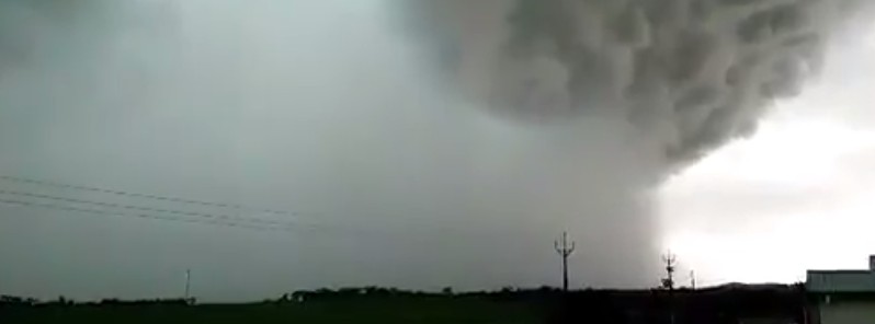
Video from farmer Michael Jaeschke of what's being described as a cyclone hitting Blyth #SAStorms #9News @9NewsAdel pic.twitter.com/25YoPmAVwm
— Jarrad Brevi (@JarradBrevi9) September 28, 2016
Video shows tornadoes forming outside Blyth during SA cyclone (credit: Michael Jaeschke) @abcnews @abcnewsAdelaide @ABCNews24 pic.twitter.com/wV1UZPzWTZ
— Tom Fedorowytsch (@tomfed) September 28, 2016
A Severe Weather Warnings for heavy rain which may lead to flash flooding is in effect in parts of New South Wales and Victoria, Flood Watches are in effect for the three southern states where rainfall over the next three days could lead to new river rises. There are still 22 Flood Warnings through the very saturated parts of eastern Australia, and the region may see some renewed and prolonged river rises with this additional rainfall.
On Thursday morning, September 29, forecasters expect seas up to 10 meters (32.8 feet) will be impacting the South Australian coastal regions.
Heaviest falls are expected in quite a short period of 6 to 12 hours, and the heaviest are expected around the northeast ranges of Victoria and southwest slopes of New South Wales.
Up to around 80 mm (3.4 inches) of rain is expected. The northeast part of Tasmania could receive up to 100 mm (3.9 inches). Overall from this system, widespread falls of 20 to 40 mm (0.8 to 1.6 inches) can be expected, but around more elevated peaks or with thunderstorm activity we could see falls up to 80 to 100 m (3.1 to 3.9 inches) .
"We have a lot of warnings in place it's very important if you're in these areas that you follow advice for emergency services," the office warned.
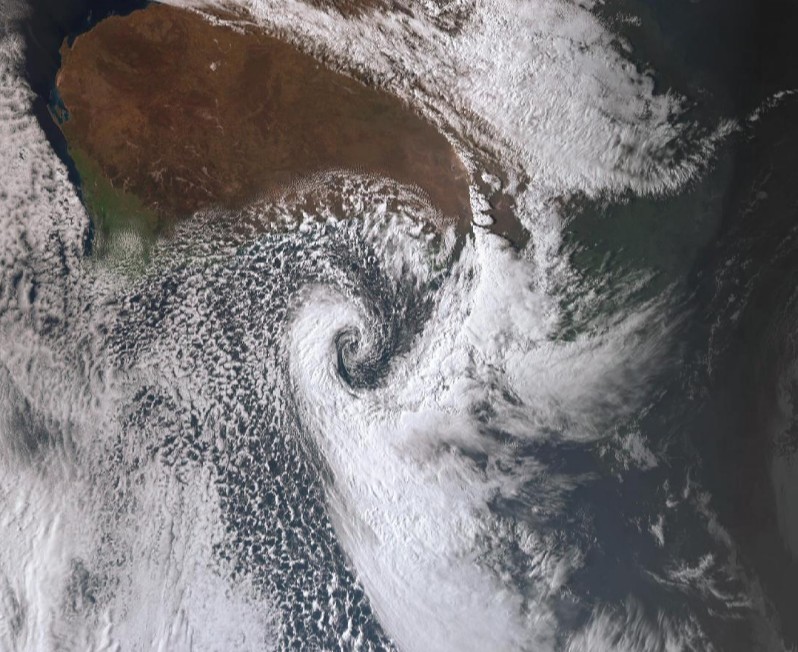
Image credit: BOM, JMA/Himawari. Acquired: 11:00 UTC on September 28, 2016
Regional Director for the Bureau of Meteorology in Tasmania Mr. John Bally said their northern catchments are already near capacity and even relatively modest falls of rain are likely to lead to strong river rises particularly in the South Esk, Macquarie, Meander, North Esk and Jordan rivers leading to minor to moderate flooding.
Featured image credit: Michael Jaeschke
no wonder the weather is shit in nz.about two weeks of rain