Neutral El Niño–Southern Oscillation (ENSO) state – neither El Niño nor La Niña
The tropical Pacific Ocean remains in a neutral El Niño–Southern Oscillation (ENSO) state – neither El Niño nor La Niña. Sea surface temperatures across the tropical Pacific have been at neutral levels for the past four weeks, with the central Pacific Ocean having recently cooled to levels close to the long-term average. Temperatures below the tropical Pacific Ocean surface are much cooler than average. In the atmosphere, indicators such as the trade winds, cloudiness near the Date Line, and the Southern Oscillation Index (SOI) are at neutral levels.
Equatorial sea surface temperatures (SSTs) in the eastern Pacific continued to cool during the past fortnight, the Australian Bureau of Meteorology reported on June 7, 2016.
Cool anomalies along the equator in the eastern Pacific extend further west than at any time since March 2014. SSTs near the equator in the western Pacific remained mostly warmer than normal.
SSTs more than 1 °C (33.8 °F) warmer than average continue to surround most of the Australian continent, except for the southwest where they are closer to average.
SSTs over large parts of the Indian Ocean remain more than 1 °C above average.
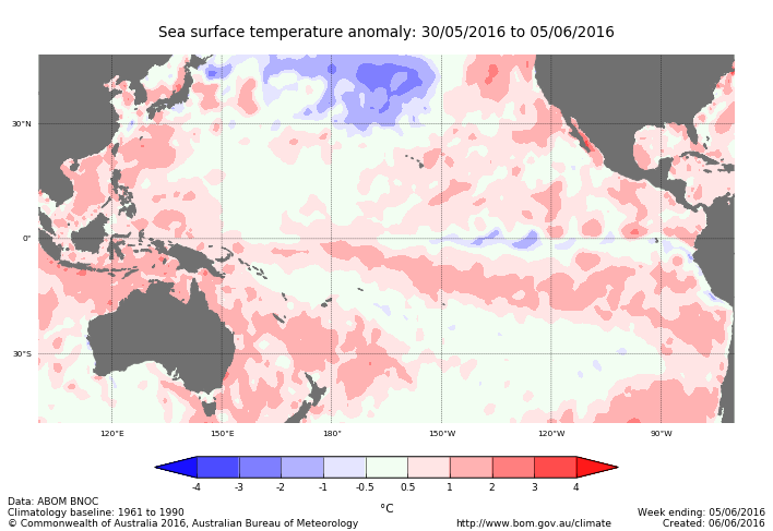
Weekly temperature anomalies in the tropical Pacific. Credit: BOM
May 2016 SSTs remained more than 1 °C above average over parts of the tropical eastern and central Pacific away from the equator. Along the equator in the eastern and central Pacific, cool anomalies covered the largest area since February 2014. The decrease in SSTs in the tropical central and eastern Pacific was consistent with the decay of El Niño.
SSTs northeast of Australia have increased since April and are again more than 1 °C warmer than average in parts.
May NINO values showed that the NINO3 region in the eastern Pacific cooled by 0.6 °C (33.08 °F) compared with April, after a similar drop the previous month. The NINO3.4 region also cooled by 0.6 °C compared to April, accelerating its cooling trend since the end of 2015. Drops of this magnitude are rarely seen and indicate the 2015-16 El Nino has declined at a rapid pace. Values in the Bureau dataset for NINO3, NINO3.4 and NINO4 were +0.2 °C, +0.4 °C and +0.6 °C (32.36 °F, 32.72 °F and 33.08 °F) for May, respectively.
Warmer than average SSTs in the western Indian Ocean returned to near average temperatures during May. SSTs in the eastern Indian Ocean also cooled but remain more than 1 °C warmer than average in parts.
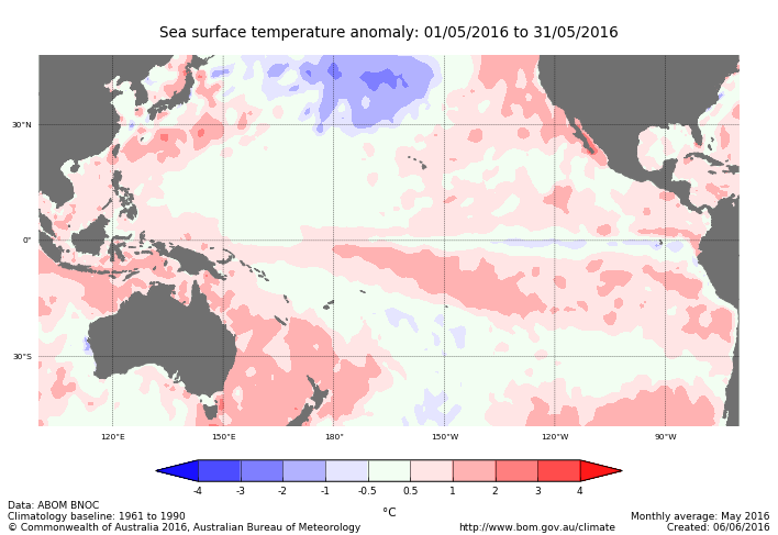
Monthly temperature anomalies in the tropical Pacific. Credit: BOM
Sub-surface temperature anomalies in the equatorial eastern Pacific continue to expand. The coolest anomalies, more than 4 °C (39.2 °F) below average, lie about 100 m (328 feet) below the surface centered around 155° W.
The four-month sequence of sub-surface temperature anomalies shows a clear cooling trend in the top 100 m of the equatorial Pacific since February. Cool anomalies have spanned the entire equatorial Pacific since April, and May removed almost all remaining warmer than average water from the top 50 m (164 feet). The top 50 m of water west of 150° W is mostly close to average temperature; east of 150° W the water is cooler than average.
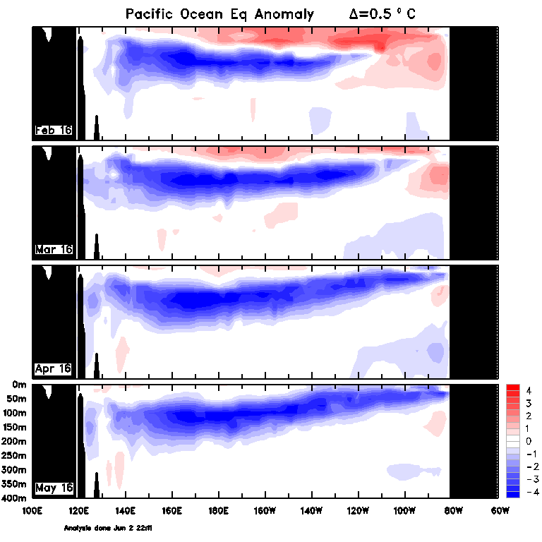
Monthly sub-surface temperature anomalies. Credit: BOM
The 30-day Southern Oscillation Index (SOI) to June 5 is +0.3. The SOI value for May was +2.3. Both values are well within the neutral ENSO range.
Sustained positive values of the SOI above +7 typically indicate La Niña while sustained negative values below −7 typically indicate El Niño. Values between about +7 and −7 generally indicate neutral conditions.
.png)
30-day SOI values for the past two years. Credit: BOM
Pacific trade winds near the equator have remained close to normal for the 5 days ending June 5, as they mostly have been since the start of March 2016. The return to near-normal trade winds is consistent with a neutral El Niño–Southern Oscillation (ENSO) state.
During La Niña events, there is a sustained strengthening of the trade winds across much of the tropical Pacific, while during El Niño events there is a sustained weakening, or even reversal, of the trade winds.
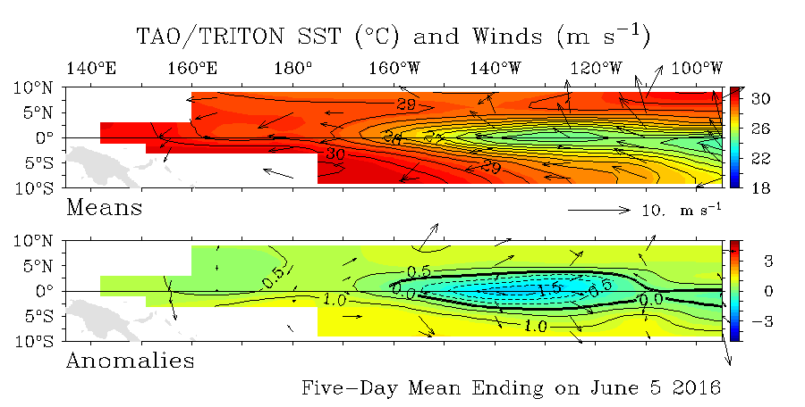
5-day SST and wind anomaly from TAO/TRITON. Credit: BOM
Cloudiness near the Date Line has been close to average since the beginning of May. Equatorial cloudiness near the Date Line typically increases during El Niño (below average OLR) and decreases during La Niña (above average OLR).
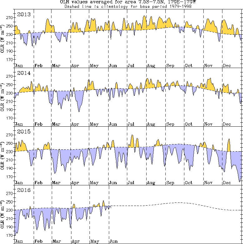
Graph of Outgoing longwave radiation (OLR) totals over the dateline. Credit: BOM
The Bureau's ENSO Outlook remains at La Niña WATCH. This suggests around a 50% likelihood of La Niña forming later in 2016. International climate models indicate the tropical Pacific Ocean will continue to cool, with six of eight models suggesting La Niña is likely to form during the austral winter (June – August).
However, individual model outlooks show a large spread between neutral and La Niña scenarios. At least one model suggests La Niña conditions may be short-lived, returning to neutral by October.
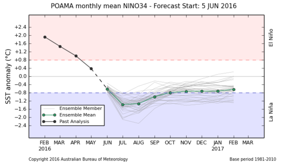
Credit: BOM
The Indian Ocean Dipole (IOD) is neutral. However, international models monitored by the Bureau indicate a negative IOD event may develop in the coming months. The weekly Dipole Mode Index value to June 5 is -0.65 °C (30.83 °F), dipping to negative IOD levels for the second consecutive week. However, it would take several more weeks of similar IOD index values before a negative IOD would be considered established.
Negative IOD events are more likely to occur during La Niña. Hence, if La Nina does develop, this will increase the likelihood of a negative IOD event developing.
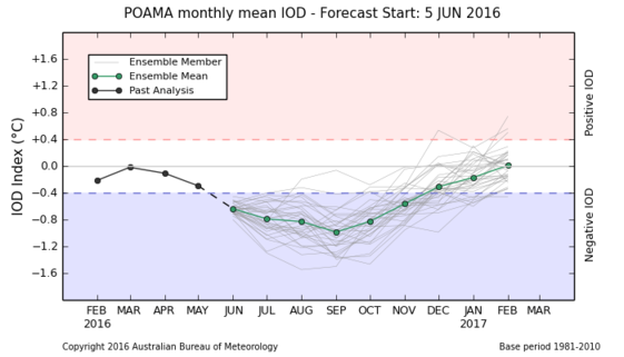
Credit: BOM
Source: ENSO Wrap-Up, June 7, 2016. BOM
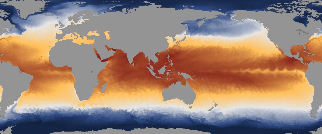
Featured image: Weekly SST, May 30 – June 5, 2016. Credit: NOAA
I guess this data means the news media may soon again be warning of a pending mini-ice age, as it did in the early 1980s. Neutral does not engender fear so the words are rarely used since that doesn’t sell well. That being said, I suspect the corporate world and American presidential hopeful Donald Trump, a climate change denier, cheer and laugh all the way to their favourite investment houses that reap huge profits for them.