Very strong and shallow M7.3 earthquake hits Kyushu, Japan
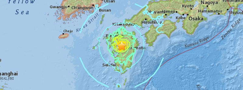
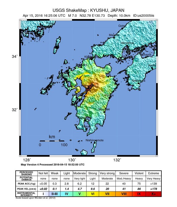
A very strong and shallow earthquake registered by the JMA as M7.3 (increased from M7.1) hit Kyushu, Japan at 16:25 UTC on April 15, 2016 (01:25 JST on April 16). The agency is reporting a depth of 10 km (6.2 miles). USGS is reporting M7.0 at a depth of 10 km (6.2 miles).
According to the USGS, the epicenter was located 1 km (0.6 miles) WSW of Kumamoto-shi, 12 km (7.5 miles) NNE of Uto, 13 km (8.1 miles) SSE of Ueki and 15 km (9.3 miles) NNE of Matsubase, Japan.
According to JMA, the quake had a maximum seismic intensity of 6+ (out of 7).
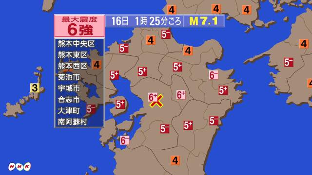
Image credit: NHK
Japan has issued a tsunami advisory for their nearby coasts. Based on all available, there is no tsunami threat from this earthquake for any other coasts, PTWC said.
There are about 8 202 442 people living within 100 km (62 miles).
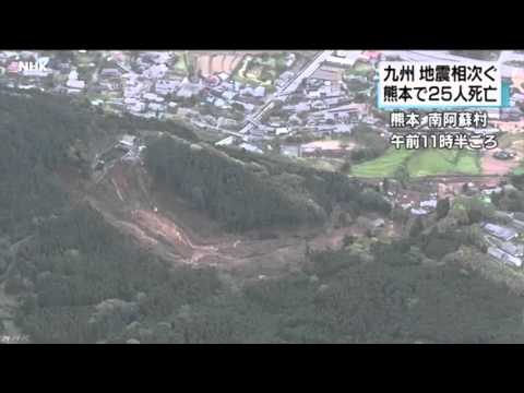
After two deadly M6.4 earthquakes and numerous aftershocks on April 14, this is a third powerful earthquake to hit Kyushu in just over 24 hours. At least 9 people were killed in yesterday's earthquakes, about 900 were injured and more than 13 000 evacuated.
Strong aftershocks are still being recorded.
USGS issued a red alert for shaking-related fatalities and economic losses. High casualties and extensive damage are probable, and the disaster is likely widespread. Past red alerts have required a national or international response.
Estimated economic losses are 0 – 1% GDP of Japan.
Overall, the population in this region resides in structures that are resistant to earthquake shaking, though some vulnerable structures exist. The predominant vulnerable building types are heavy wood frame and low-rise concrete wall construction.
Recent earthquakes in this area have caused secondary hazards such as tsunamis and landslides that might have contributed to losses.
Moderate-to-large, shallow earthquakes in Kyushu are infrequent – most seismicity in the region is related to the subduction of the Philippine Sea plate at depth. Thirteen M5+ earthquakes have occurred at shallow depths (> 50 km / 31 miles) within 100 km of the April 14th epicenter over the past century.
In January and April of 1975, two shallow events with magnitudes of M5.8 and M6.1 (USGS) – 40 km (24.8 miles) and 65 km (40.4 miles) to the northwest of the April 14, 2016 earthquake, respectively – caused injuries, but no known fatalities. A shallow M6.6 earthquake in March 2005, just off the north coast of Kyushu and 110 km (68.3 miles) north of the April 2016 events, caused over 1 000 injuries and at least one fatality.
Updates
16:50 UTC
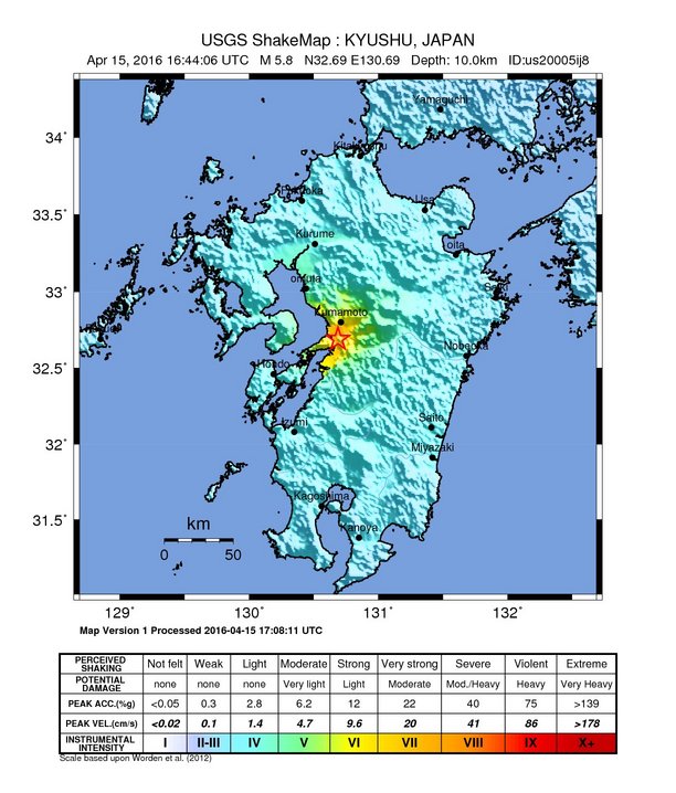
Another strong earthquake, registered as M6.0 by the JMA hit at 16:44 UTC. USGS registered it as M5.8.
17:36 UTC
JMA has lifted off tsunami advisories.
17:39 UTC
Professor Max Wyss, who specializes in theoretical prognoses of injuries and fatalities expects:
- Injuries – 700 to 8 000
- Fatalities – 200 to 2 000
Damage specialist Dr. James Daniell (CEDIM Karlsruhe) projects the following numbers (after this aftershock):
- Updated loss estimate:– $12 billion with a range from $5-23 billion currently
- 110 fatalities expected with a range from 12 to around 900 (ER)
17:43 UTC
A lot of damage reports are coming in.
A widespread power outage is reported in Kumamoto.
18:15 UTC
Collapsed houses reported, gas leakages, bridges and tunnels collapsed… people buried under rubble.
JMA said this quake might be the major one, not the one yesterday.
18:38 UTC
There are fears that Kumamoto Shimin Hospital may collapse. An evacuation is being considered. This hospital has around 500 beds.
Heavy rain and strong winds are forecast from Saturday evening in quake-hit regions. JMA said quakes may have loosened the ground, and the stormy weather could trigger landslides and other disasters.
19:49 UTC
According to Kyushu Electronic Power, about 190 400 households are out of electricity.
NHK reports that reservoir dam near Nishihara in Kumamoto may have been damaged, villagers are evacuating.
A large fire has broken out in Yatsyshiro City.
Water supply all out across Kumamoto prefecture.
JMA increased the magnitude to M7.3.
20:07 UTC
It is currently 05:07 JST. The night will be over soon.
20:13 UTC
At least 1 person was killed, several hundred injured.
66 people are reportedly trapped in a nursery home in Mishake.
Liquefaction, landslides and fires in many places reported.
20:30 UTC
202 800 houses are out of power, Kyushu Electric Power Company said.
Units 1 and 2 of Sendai nuclear power plant are working. Genkai nuclear power plant is not working, but the abnormal state of the plant has not been confirmed.
More than 400 people are being treated in hospitals.
20:37 UTC
Aso shrine has been destroyed. Aso is one of the oldest and most prominent shrines in Japan.
元はこんなに綺麗な阿蘇神社が、、、
悲惨すぎる、、、 pic.twitter.com/6hvkqZyPgJ— と=͟͟͞͞も=͟͟͞͞や=͟͟͞͞ (@tomoyan8826) April 15, 2016
20:41 UTC
Famous Aso bridge has completely collapsed.
21:48 UTC
Gavin Hayes, research geophysicist with the USGS, said the fault-line from today's earthquake was much longer than that of yesterday's. "The ground surface would have moved in the region of 4 – 5 m. So, you are talking very intense shaking over quite a large area."

22:28 UTC
At least 3 people have reportedly been killed and 470 injured.
JMA scientists are warning the Kyushu citizens to be extremely cautious as very strong aftershocks may happen within a week.
April 16, 2016
01:33 UTC
Video update by NKH Meteorologist Jonathan Oh

08:33 UTC
The toll of the earthquake at this moment is at least 20 fatalities and 2 000 people injured. Together with the mainshock: 29 fatalities and 3 129 injured. (ER)
SHIFT: The powerful earthquakes in Kyushu are not only demolishing houses. We're seeing changes in the landscape. pic.twitter.com/X0L5UC8AqW
— Jonathan Oh (@johontv) April 16, 2016
LANDSLIDE: A picture of one of the landslides in Kyushu. More situations like these are likely to unfold. pic.twitter.com/EDbI3tDkC0
— Jonathan Oh (@johontv) April 16, 2016
Latest radar at 2:50pm shows light rain band beginning to pass thru Kyushu island. pic.twitter.com/5STmrzAnqJ
— Weather Mizumoto (@hepomodeler) April 16, 2016
08:44 UTC
A massive landslide swamped a community in Kumamoto, several people are missing.
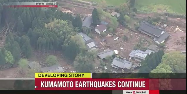
Image credit: NHK
08:47 UTC
The following video compilation shows the moment M7.3 earthquake struck and the extent of the damage.

09:00 UTC
Evacuation advisory was issued for some places in Kumamoto. Heavy rainfall is expected to cause more landslides overnight.
It is currently 18:00 in Japan.
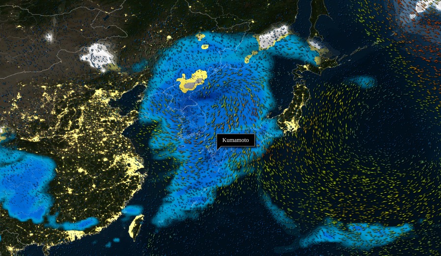
Weather forecast for April 16 – 17, 2016. Credit: MeteoEarth
09:09 UTC
#แผ่นดินไหวญี่ปุ่น #prayforkumamoto #KumamotoQuakes #KumamotoEarthquake pic.twitter.com/Q6Lewsb72c
— HisoEsther (@HisoEsther) April 16, 2016
15:41 UTC
According to officials, 37 people have died since the first earthquake struck on Thursday, April 14. 28 died as a result of April 15th M7.3 and 9 from Thursday's M6.4 foreshock. 90 houses in Kumamoto prefecture have been destroyed.
Here is a full updated from Jonathan Oh, NHK Meteorologist:
April 17, 13:46 UTC
According to officials, 41 people have died since the first earthquake struck on Thursday, April 14.
Latest update from Jonathan Oh:
April 18, 21:53 UTC
According to latest reports, 42 people have died since earthquakes started on April 14.
Seismotectonics of the Philippine Sea and Vicinity
The Philippine Sea plate is bordered by the larger Pacific and Eurasia plates and the smaller Sunda plate. The Philippine Sea plate is unusual in that its borders are nearly all zones of plate convergence. The Pacific plate is subducted into the mantle, south of Japan, beneath the Izu-Bonin and Mariana island arcs, which extend more than 3,000 km along the eastern margin of the Philippine Sea plate. This subduction zone is characterized by rapid plate convergence and high-level seismicity extending to depths of over 600 km. In spite of this extensive zone of plate convergence, the plate interface has been associated with few great (M>8.0) ‘megathrust’ earthquakes. This low seismic energy release is thought to result from weak coupling along the plate interface (Scholz and Campos, 1995). These convergent plate margins are also associated with unusual zones of back-arc extension (along with resulting seismic activity) that decouple the volcanic island arcs from the remainder of the Philippine Sea Plate (Karig et al., 1978; Klaus et al., 1992).
South of the Mariana arc, the Pacific plate is subducted beneath the Yap Islands along the Yap trench. The long zone of Pacific plate subduction at the eastern margin of the Philippine Sea Plate is responsible for the generation of the deep Izu-Bonin, Mariana, and Yap trenches as well as parallel chains of islands and volcanoes, typical of circum-pacific island arcs. Similarly, the northwestern margin of the Philippine Sea plate is subducting beneath the Eurasia plate along a convergent zone, extending from southern Honshu to the northeastern coast of Taiwan, manifested by the Ryukyu Islands and the Nansei-Shoto (Ryukyu) trench. The Ryukyu Subduction Zone is associated with a similar zone of back-arc extension, the Okinawa Trough. At Taiwan, the plate boundary is characterized by a zone of arc-continent collision, whereby the northern end of the Luzon island arc is colliding with the buoyant crust of the Eurasia continental margin offshore China.
Along its western margin, the Philippine Sea plate is associated with a zone of oblique convergence with the Sunda Plate. This highly active convergent plate boundary extends along both sides the Philippine Islands, from Luzon in the north to the Celebes Islands in the south. The tectonic setting of the Philippines is unusual in several respects: it is characterized by opposite-facing subduction systems on its east and west sides; the archipelago is cut by a major transform fault, the Philippine Fault; and the arc complex itself is marked by active volcanism, faulting, and high seismic activity. Subduction of the Philippine Sea Plate occurs at the eastern margin of the archipelago along the Philippine Trench and its northern extension, the East Luzon Trough. The East Luzon Trough is thought to be an unusual example of a subduction zone in the process of formation, as the Philippine Trench system gradually extends northward (Hamburger et al., 1983). On the west side of Luzon, the Sunda Plate subducts eastward along a series of trenches, including the Manila Trench in the north, the smaller less well-developed Negros Trench in the central Philippines, and the Sulu and Cotabato trenches in the south (Cardwell et al., 1980). At its northern and southern terminations, subduction at the Manila Trench is interrupted by arc-continent collision, between the northern Philippine arc and the Eurasian continental margin at Taiwan and between the Sulu-Borneo Block and Luzon at the island of Mindoro. The Philippine fault, which extends over 1,200 km within the Philippine arc, is seismically active. The fault has been associated with major historical earthquakes, including the destructive M7.6 Luzon earthquake of 1990 (Yoshida and Abe, 1992). A number of other active intra-arc fault systems are associated with high seismic activity, including the Cotabato Fault and the Verde Passage-Sibuyan Sea Fault (Galgana et al., 2007).
Relative plate motion vectors near the Philippines (about 80 mm/yr) is oblique to the plate boundary along the two plate margins of central Luzon, where it is partitioned into orthogonal plate convergence along the trenches and nearly pure translational motion along the Philippine Fault (Barrier et al., 1991). Profiles B and C reveal evidence of opposing inclined seismic zones at intermediate depths (roughly 70-300 km) and complex tectonics at the surface along the Philippine Fault.
Several relevant tectonic elements, plate boundaries and active volcanoes, provide a context for the seismicity presented on the main map. The plate boundaries are most accurate along the axis of the trenches and more diffuse or speculative in the South China Sea and Lesser Sunda Islands. The active volcanic arcs (Siebert and Simkin, 2002) follow the Izu, Volcano, Mariana, and Ryukyu island chains and the main Philippine islands parallel to the Manila, Negros, Cotabato, and Philippine trenches.
Seismic activity along the boundaries of the Philippine Sea Plate (Allen et al., 2009) has produced 7 great (M>8.0) earthquakes and 250 large (M>7) events. Among the most destructive events were the 1923 Kanto, the 1948 Fukui and the 1995 Kobe (Japan) earthquakes (99,000, 5,100, and 6,400 casualties, respectively), the 1935 and the 1999 Chi-Chi (Taiwan) earthquakes (3,300 and 2,500 casualties, respectively), and the 1976 M7.6 Moro Gulf and 1990 M7.6 Luzon (Philippines) earthquakes (7,100 and 2,400 casualties, respectively). There have also been a number of tsunami-generating events in the region, including the Moro Gulf earthquake, whose tsunami resulted in more than 5000 deaths. (USGS) More information on regional seismicity and tectonics
Featured image credit: USGS
Holy Cow!!!
http://web.volcanodiscovery.com/fileadmin/charts/quakes-v1471_9_4_2016_16_04_2016.png
I put a screen grab on my blog –
http://flyingcuttlefish.files.wordpress.com/2016/04/mtaso_quakes.jpg
Some Japan volcano live cam links are in the comments ….
http://flyingcuttlefish.files.wordpress.com/
Can you keep an eye on this volcano that erupted there today?
http://www.reuters.com/article/us-japan-quake-volcano-idUSKCN0XD01O
The only info I have is from Japan govt. and I don’t trust them!
Sure FC!