Category 4 Typhoon “Chan-hom” heading toward Shanghai, China
Powerful Typhoon "Chan-hom" passed between Miyakojima and Okinawa islands, Japan late July 9 and early July 10 (UTC) packing winds of up to 222 km/h (138 mph). This made Chan-hom a Category 4 typhoon on the Saffir-Simpson wind scale. Chan-hom is expected to hit Fujian or Zhejiang provinces late Friday, July 10 or early Saturday, July 11, 2015 (UTC) and pass near or over Shanghai on July 12 as a Category 1 typhoon.
On July 9 at 02:05 UTC the MODIS instrument aboard NASA's Terra satellite captured an image of "Chan-hom" east of Taiwan. The image clearly showed an eye with powerful bands of thunderstorms spiraling into the center of circulation.
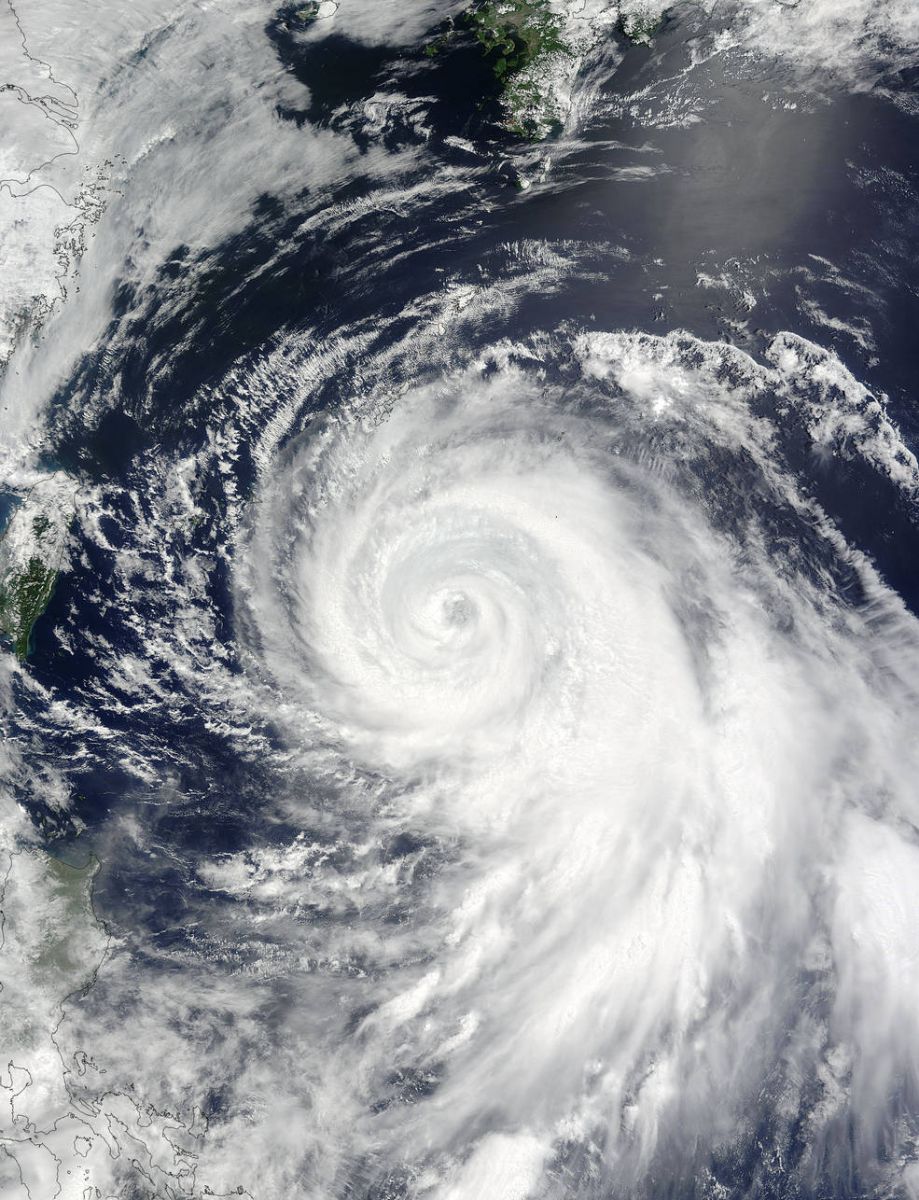
Typhoon "Chan-hom" on July 9, 2015. Image credit: NASA Terra/MODIS.
According to the JTWC, Chan-hom was located approximately 250 km (155 miles) SW of Okinawa Island at 03:00 UTC on July 10 and has tracked WNW at 20.3 km (12.6 mph) over the past six hours.
Maximum significant wave height at 00:00 UTC was 12.8 meters (42 feet). At the same time, Chan-hom's maximum sustained winds were 222 km/h (138 mph), gusts were up to 268.5 km/h (166.8 mph).
Recent animated multispectral satellite imagery continues to depict vigorous feeder bands wrapping into a well-defined 27.8 km (17.2 miles) diameter eye, JTWC noted.
The system is expected to maintain the current intensity in the short term. Afterward, unfavorable environmental conditions will start the weakening trend. Over the next 36 hours, Chan-hom will further weaken as it tracks over eastern China.
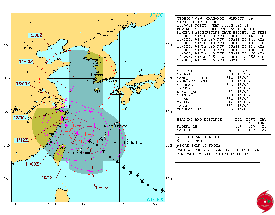
Typhoon "Chan-hom" forecast track by JTWC on July 10, 2015. Image credit: JTWC/ATCF.
Chan-hom is forecast to hit Fujian or Zhejiang provinces late Friday, July 10 or early Saturday, July 11, 2015 (UTC).
Current forecast track by JTWC takes the system near or over Shanghai, the most populated city in the world, on July 12 as a Category 1 typhoon. Its maximum sustained wind speed is expected to be around 148 km/h (92 mph) when it approaches the city.
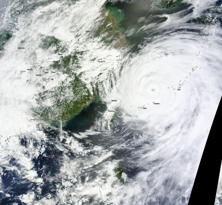
Typhoon "Chan-hom" on July 10, 2015. Image credit: NASA Terra/MODIS.
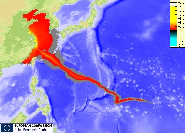
Storm surge maximum height. Image credit: JRC.

Video credit Earth Uncut TV
Super Typhoon "Nangka"
Meanwhile, Super Typhoon "Nangka", with maximum sustained winds near 241 km/h (150 mph), is located NNW of Guam and is tracking W at 16.7 km/h (10.3 mph). Nangka is now in a weakening trend, however, it is expected to start intensifying again on July 15. Its current forecast track takes it toward mainland Japan.
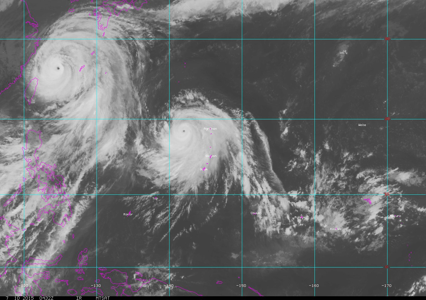
Typhoon "Chan-hom" and Super Typhoon "Nangka" on July 10, 2015. Image credit: MTSAT.
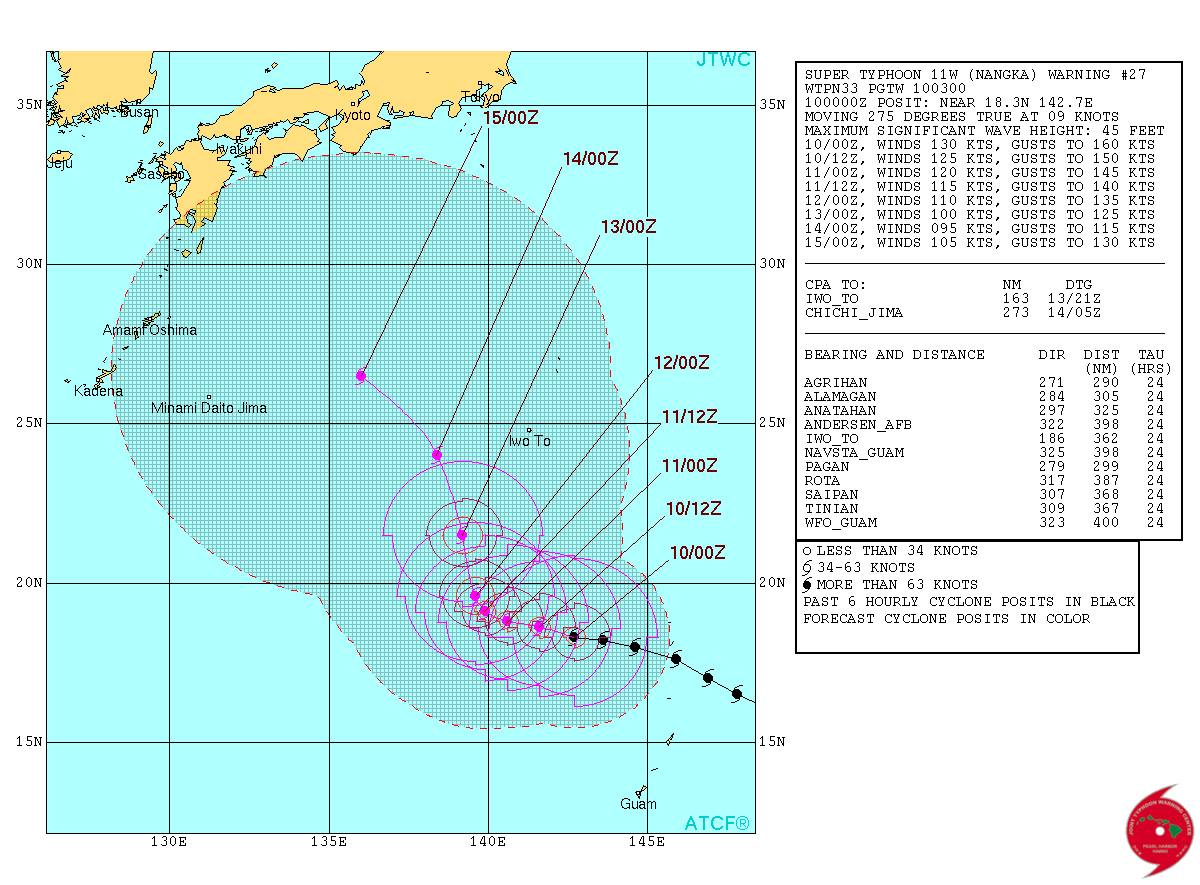
Super Typhoon "Nangka" forecast track by JTWC on July 10, 2015. Image credit: JTWC/ATCF.
Chan-hom satellite animations
- Storm-Centered Infrared (MTSAT2; NOAA/SSD)
- Storm-Centered Infrared (Aviation Color Enhancement) (MTSAT2; NOAA/SSD)
- Storm-Centered Water Vapor (MTSAT2; NOAA/SSD)
- Storm-Centered Visible (MTSAT2; NOAA/SSD)
- Storm-Centered Visible (Colorized) (MTSAT2; NOAA/SSD)
- Storm-Centered Infrared (MTSAT2; CIMSS)
- Storm-Centered Enhanced Infrared (MTSAT2; CIMSS)
- Storm-Centered Water Vapor (MTSAT2; CIMSS)
- Storm-Centered Visible (MTSAT2; CIMSS)
- Tropical West Pacific Infrared (MTSAT2; NOAA)
- Tropical West Pacific Enhanced Infrared (MTSAT2; NOAA)
- Tropical West Pacific Water Vapor (MTSAT2; NOAA)
- Tropical West Pacific Visible (MTSAT2; NOAA)
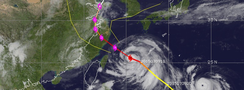
Featured image: Chan-hom forecast track on July 10, 2015 by UW-CIMSS.
the end is near .. too much is pointing to that .. live 24 hours at a time .. live like every day ur last day .. mark v d m . south Africa .