Extremely strong and very deep M8.5 earthquake hits Bonin Islands region, Japan
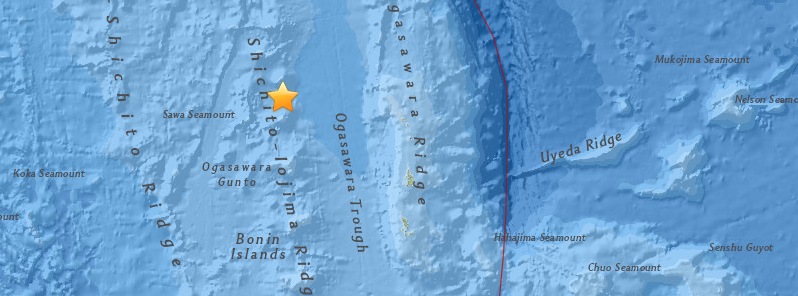
Extremely strong and very deep M8.5 earthquake was registered by Japan Meteorological Agency (JMA) off the coast of Chichi-shima, Bonin Islands region (Ogasawara), Japan at 11:23 UTC on May 30, 2015. JMA is reporting depth of 590 km (366 miles).
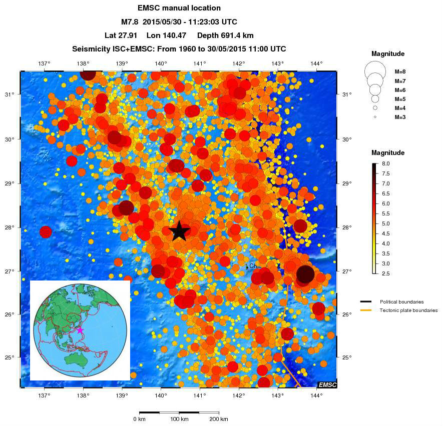
Preliminary report by USGS said M8.5 at a depth of 696.0 km (432.5 miles), and was later revised to M7.8 at a depth of 677.6 km (421.0 miles).
According to the USGS, epicenter was located 166 km (103 miles) WNW of Chichi-shima, 770 km (478 miles) SSE of Shimoda, 782 km (486 miles) SSE of Oyama, 790 km (491 miles) S of Tateyama, and 870 km (541 miles) S of Tokyo, Japan.
There are no people living within 100 km radius.
Based on all available data, there is no tsunami threat because the earthquake is located too deep inside the Earth.
Nishino-shima, a new island created by ongoing volcanic erupton, is about 43.5 km (26 miles) SSE away from the earthquake epicenter.

![]()
Image credit: © 2010 Google / USGS.
USGS said today's earthquake occurred as the result of oblique-normal faulting at a depth of over 660 km beneath the Pacific Ocean. The earthquake is located within the interior of the Pacific plate that subducts beneath Japan starting at the Izu trench, several hundred kilometers to the east of the event (and at the surface of the Earth). At the location of the earthquake, the Pacific plate moves approximately westwards with respect to the Philippine Sea plate at a rate of 39 mm/yr. This earthquake occurred in response to stresses generated by the slow distortion of the Pacific plate at depth, rather than occurring on the interface between the Pacific plate and the overriding Philippine Sea plate.
Earthquakes that have focal depths greater than 300 km are commonly termed "deep-focus".
Deep-focus earthquakes cause less damage on the earth’s surface above their foci than is the case with similar magnitude shallow-focus earthquakes. Large deep-focus earthquakes may be felt at great distance from their epicenters. The largest recorded deep-focus earthquake was a 2013 M 8.3 earthquake that occurred at a depth of 600 km within the subducted Pacific plate beneath the Sea of Okhotsk, offshore northeastern Russia [keep in mind USGS reports this earthquake as M7.8]. The M 8.3 Okhotsk earthquake was felt all over Asia, as far away as Moscow, and across the Pacific along the western seaboard of the United States.
Over the past century, 66 earthquakes with a magnitude of M7 or more have occurred at depths greater than 500 km; three of these were located in the same region as today's event. The largest nearby event at these depths was a 1968 M 7.3 earthquake, several hundred kilometers to the south of this earthquake. (USGS)
Update
JMA recorded a second strong quake about 449 km NE of the M8.5 epicenter – M6.3 at a shallow depth of 10 km (6.2 miles). USGS reports it as M6.4 at a depth of 13.4 km (8.3 miles).
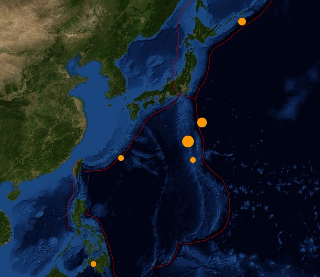
Image credit: USGS.
Seismotectonics of the Philippine Sea and Vicinity
The Philippine Sea plate is bordered by the larger Pacific and Eurasia plates and the smaller Sunda plate. The Philippine Sea plate is unusual in that its borders are nearly all zones of plate convergence. The Pacific plate is subducted into the mantle, south of Japan, beneath the Izu-Bonin and Mariana island arcs, which extend more than 3,000 km along the eastern margin of the Philippine Sea plate. This subduction zone is characterized by rapid plate convergence and high-level seismicity extending to depths of over 600 km. In spite of this extensive zone of plate convergence, the plate interface has been associated with few great (M>8.0) ‘megathrust’ earthquakes. This low seismic energy release is thought to result from weak coupling along the plate interface (Scholz and Campos, 1995). These convergent plate margins are also associated with unusual zones of back-arc extension (along with resulting seismic activity) that decouple the volcanic island arcs from the remainder of the Philippine Sea Plate (Karig et al., 1978; Klaus et al., 1992).
South of the Mariana arc, the Pacific plate is subducted beneath the Yap Islands along the Yap trench. The long zone of Pacific plate subduction at the eastern margin of the Philippine Sea Plate is responsible for the generation of the deep Izu-Bonin, Mariana, and Yap trenches as well as parallel chains of islands and volcanoes, typical of circum-pacific island arcs. Similarly, the northwestern margin of the Philippine Sea plate is subducting beneath the Eurasia plate along a convergent zone, extending from southern Honshu to the northeastern coast of Taiwan, manifested by the Ryukyu Islands and the Nansei-Shoto (Ryukyu) trench. The Ryukyu Subduction Zone is associated with a similar zone of back-arc extension, the Okinawa Trough. At Taiwan, the plate boundary is characterized by a zone of arc-continent collision, whereby the northern end of the Luzon island arc is colliding with the buoyant crust of the Eurasia continental margin offshore China.
Along its western margin, the Philippine Sea plate is associated with a zone of oblique convergence with the Sunda Plate. This highly active convergent plate boundary extends along both sides the Philippine Islands, from Luzon in the north to the Celebes Islands in the south. The tectonic setting of the Philippines is unusual in several respects: it is characterized by opposite-facing subduction systems on its east and west sides; the archipelago is cut by a major transform fault, the Philippine Fault; and the arc complex itself is marked by active volcanism, faulting, and high seismic activity. Subduction of the Philippine Sea Plate occurs at the eastern margin of the archipelago along the Philippine Trench and its northern extension, the East Luzon Trough. The East Luzon Trough is thought to be an unusual example of a subduction zone in the process of formation, as the Philippine Trench system gradually extends northward (Hamburger et al., 1983). On the west side of Luzon, the Sunda Plate subducts eastward along a series of trenches, including the Manila Trench in the north, the smaller less well-developed Negros Trench in the central Philippines, and the Sulu and Cotabato trenches in the south (Cardwell et al., 1980). At its northern and southern terminations, subduction at the Manila Trench is interrupted by arc-continent collision, between the northern Philippine arc and the Eurasian continental margin at Taiwan and between the Sulu-Borneo Block and Luzon at the island of Mindoro. The Philippine fault, which extends over 1,200 km within the Philippine arc, is seismically active. The fault has been associated with major historical earthquakes, including the destructive M7.6 Luzon earthquake of 1990 (Yoshida and Abe, 1992). A number of other active intra-arc fault systems are associated with high seismic activity, including the Cotabato Fault and the Verde Passage-Sibuyan Sea Fault (Galgana et al., 2007).
Relative plate motion vectors near the Philippines (about 80 mm/yr) is oblique to the plate boundary along the two plate margins of central Luzon, where it is partitioned into orthogonal plate convergence along the trenches and nearly pure translational motion along the Philippine Fault (Barrier et al., 1991). Profiles B and C reveal evidence of opposing inclined seismic zones at intermediate depths (roughly 70-300 km) and complex tectonics at the surface along the Philippine Fault.
Several relevant tectonic elements, plate boundaries and active volcanoes, provide a context for the seismicity presented on the main map. The plate boundaries are most accurate along the axis of the trenches and more diffuse or speculative in the South China Sea and Lesser Sunda Islands. The active volcanic arcs (Siebert and Simkin, 2002) follow the Izu, Volcano, Mariana, and Ryukyu island chains and the main Philippine islands parallel to the Manila, Negros, Cotabato, and Philippine trenches.
Seismic activity along the boundaries of the Philippine Sea Plate (Allen et al., 2009) has produced 7 great (M>8.0) earthquakes and 250 large (M>7) events. Among the most destructive events were the 1923 Kanto, the 1948 Fukui and the 1995 Kobe (Japan) earthquakes (99,000, 5,100, and 6,400 casualties, respectively), the 1935 and the 1999 Chi-Chi (Taiwan) earthquakes (3,300 and 2,500 casualties, respectively), and the 1976 M7.6 Moro Gulf and 1990 M7.6 Luzon (Philippines) earthquakes (7,100 and 2,400 casualties, respectively). There have also been a number of tsunami-generating events in the region, including the Moro Gulf earthquake, whose tsunami resulted in more than 5000 deaths. (USGS) More information on regional seismicity and tectonics
Featured image credit: USGS
Your comment is very strange. Apparently you are an expert on chicken shit but I am not sure if you are an expert on anything else. Your comments don’t make sense. Say what you mean.
Bullshit a little here. First, I commend you for NOT using the shitty USGS “magnitude” numbers since the Nepal EQ. Second, there is no such thing as a massive AND deep EQ unless there is not much below your feet. It is shit made up by the scientists, AKA sick homo-sapiens. This is not as big an EQ as most think. In fact, I would take the one that struck in Michigan on 5/2 over this one on any given time=space.
But when all is past, one can see May is very similar to April in terms of time=space. It has more EQ power but less volcanic power. But overall, April is no match for May in terms of the overall, despite the fact the Nepal EQ is severely underrated. If Fukushima is rated 9.1 or whatever, then the Nepal should be at least 9.9. Very few had ever bothered to watch the heaven in the next 2-3 weeks, using the most advanced camera ever created: human eyes. I love scientists to use their shitty instrument such as telescope. Keep using it. Do not be distracted.
But, but and but all of these so far is just chicken shit.
Remind you what HE, the ONE, 1 1 1, is up against:
More than 6 thousands of years of shitting off the right track. Wonder why Plato is so sentimental about the Atlantis? I can feel his pain. It has been a pain in the ass ever since.
To undo all this pile of shit, chicken shit will not do it.
For that, I remain humble. Chicken shit is a necessary step, to be replaced by…
What the movie “San Andreas” depicted is chicken shit. How do I know? A helicopter ( aka shitty bird) can even fly over that shit. Go see that movie, the religious science followers. And do what they say, be prepared. Keep driving and dreaming.
“Rock-a-bye baby, on the treetop,
When the wind blows, the cradle will rock,
When the bough breaks, the cradle will fall,
And down will come baby, cradle and all.”
Kiss, kiss and kiss. Good day and night.