USGS: Reawakened Oklahoma faults could produce larger future events
Reactivated faults that have produced thousands of Oklahoma earthquakes are capable of causing larger seismic events, according to USGS research conducted in cooperation with the Oklahoma Geological Survey.
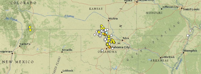
Since late 2009 the rate of magnitude 3 or larger earthquakes in north-central Oklahoma has been nearly 300 times higher than in previous decades. More than 3,600 earthquakes between 2009 and 2014 were located and determined to occur on near-vertical, strike-slip faults at a shallow depth of 4 to 6 kilometers. Several of these earthquakes caused damage and many were felt, with over 153,000 individual felt reports for 474 separate earthquakes entered at the USGS Did You Feel It? (DYFI) website.
These reactivated structures were originally formed approximately 300 million years ago and are well known as structural traps in oil and gas bearing geologic formations. A primary reason for reactivation is the northeast or northwest orientation of the faults relative to the east to west direction of regional tectonic stress in earth’s upper crust, which increases the probability of a future, larger earthquake.
Several recent studies have linked Oklahoma earthquakes with the injection of wastewater from enhanced oil and gas exploration. The purpose of this new study is to inform engineers, the insurance industry and government agencies about the increased earthquake risk in the state, and not to link earthquakes in Oklahoma to oil and gas extraction.
These findings will be used to develop a new earthquake-hazard map for Oklahoma that the USGS is planning to issue later this year, which will mark the first time the state’s earthquake hazard maps will include suspected human-induced earthquakes.
Current hazard maps, which show the likelihood of an area experiencing earthquake shaking of various intensities, do not include induced seismicity and could be underestimating the earthquake hazard for Oklahoma and other states, explained Dan McNamara, USGS research geophysicist and lead author of the new paper.
Augmenting these maps with information about the type, length and location, of the reactivated faults will help officials provide guidance to the oil and gas industry and aid in adapting building codes to ensure that structures can withstand more damaging earthquakes, he added.
The research was published last week in Geophysical Research Letters.
Source: USGS
Featured image credit: USGS
Actually, I have been wondering if a combination of factors might increase the likelihood of CONUS-wide geological collapse and an oceanic counter-flood of the Mississippi/Missouri/Ohio River basins, as prophesied (for illustration purposes) by Edgar Cayce. These factors — each contributing synergistically to a potential tipping point of meta-geological instability — would include but not be limited to:
Widespread fracking
Aquifer depletion for industrial farming
Conventional petroleum and natural gas extraction
Redistribution of water and ice across oceans and continental surfaces due to global warming — semi-permanent mountain deglaciation, lake emptying and surface drought, combined with more massive water weight over the sea beds.
Unaccustomed earthquake swarms in Oklahoma and Texas, on the Nevada/Oregon border and around that latitude in the near offshore Pacific.
Multiply by other environmental factors worldwide: tundra thawing, tropical forest depletion, clatrate release, increase in the frequency over the last century of 8.5+ earthquakes in the Circle of Fire, more and stronger hurricanes, etc.