Tropical Storm “Genevieve” forms, dies, resurrects and intensifies to Super-Typhoon
Tropical Storm "Genevieve" was born on Friday, July 25 at 09:00 UTC in Eastern Pacific Ocean. At the time it had maximum sustained winds near 40 mph (65 km/h) and was located about 1 490 miles (2 400 km) east-southeast of South Point, Hawaii.
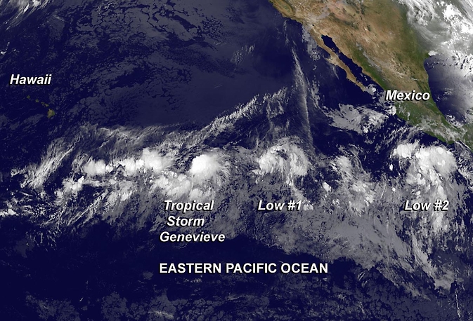
NOAA's GOES-West satellite captured this infrared picture on July 25 at 12:00 UTC of Tropical Storm Genevieve (left) followed to the east by two other developing areas of low pressure. Image Credit: NASA/NOAA GOES Project
By Sunday, July 27 Tropical Storm Genevieve weakened to a tropical depression and National Hurricane Center (NHC) issued what they thought was their final advisory on the system as it was entering the Central Pacific. At 09:00 UTC that day, the depression was located about 1 130 miles (1 820 km) east-southeast of South Point, Hawaii. It was moving to the west near 9 mph (14.4 km/h) and had maximum sustained winds near 35 mph (55 km/h).
By Monday, July 28 at 12:00 UTC Genevieve became a remnant low pressure area located about 780 miles (1 255 km) southeast of Hilo, Hawaii. The Central Pacific Hurricane Center (CPHC) noted that this may not be the last of Genevieve, however, as "environmental conditions may be somewhat conducive for development of this system as it continues to move westward at about 10 mph (16 km/h) during the next couple of days." CPHC gave Genevieve's remnants a 30 percent chance of making a comeback in the next couple of days.
On July 30, after three days of living as a remnant low pressure area, Genevieve reorganized and was again classified as a tropical depression.
Infrared imagery from NASA's Aqua satellite helped confirm that the remnant low pressure area of former Tropical Storm Genevieve has become a Zombie storm, and has been reborn as a tropical depression on July 30.
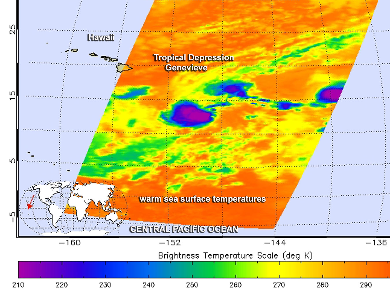
The AIRS instrument aboard NASA's Aqua satellite captured this infrared image of strong thunderstorms (purple) that redeveloped around Genevieve's center on July 30 at 11:29 UTC. Image credit: NASA JPL, Ed Olsen
According to NOAA's CPHC, Genevieve's maximum sustained winds on that day were near 35 mph (55 km/h) and some strengthening was expected during the next two days, with Genevieve likely becoming a tropical storm within the next day.
By July 31, the resurrected Tropical Depression Genevieve appeared squeezed between three other developing areas of low pressure. Satellite data from NOAA and NASA continued showing a lot of tropical activity in the Eastern and Central Pacific Oceans.
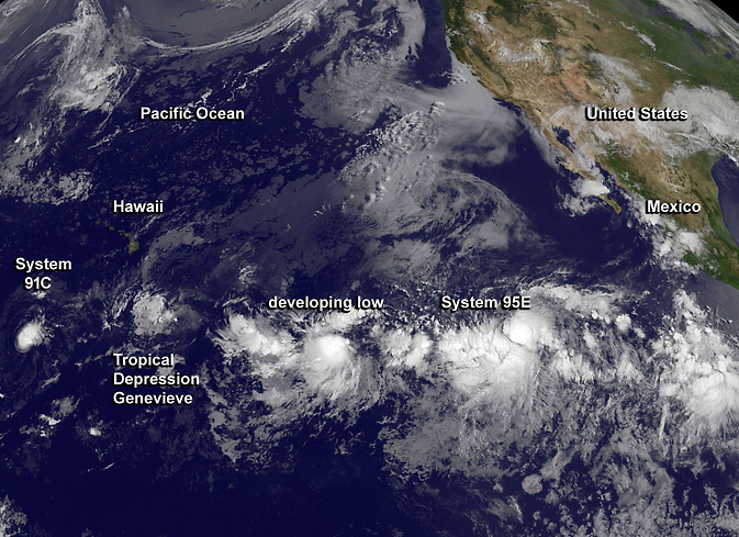
Four tropical low pressure systems, including Tropical Depression Genevieve were captured in this GOES-West satellite combination infrared and visible image from July 31 at 15:00 UTC. Image credit: NASA/NOAA GOES Project
Hyperactive Eastern and Central Pacific Ocean
At 12:00 UTC on August 1, Genevieve's remnant low center was located about 500 miles (804 km) south-southeast of Hilo, Hawaii. CPHC noted the atmospheric conditions are only marginally favorable for its redevelopment over the next few days as it moves westward near 10 mph (16 km/h).
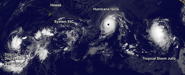
But on that day, there were 5 developing tropical systems in the Eastern and Central Pacific. All five of them are visible on the following NOAA GOES-West image (left to right) taken on August 1: System 91C, Genevieve, System 96E, Iselle, and a tropical wave.
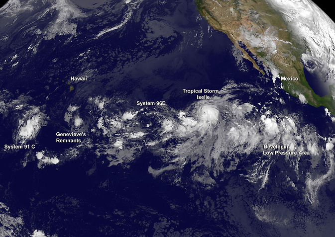
Image credit: NASA/NOAA GOES Project
On August 4, Tropical Depression Genevieve was located about 930 miles (1 495 km) southwest of Honolulu, Hawaii. Maximum sustained winds were near 35 mph (55 km/h). Genevieve was moving westward at about 16 mph (26 km/h). NOAA's CPHC forecasted gradual strengthening late on August 4 and 5.
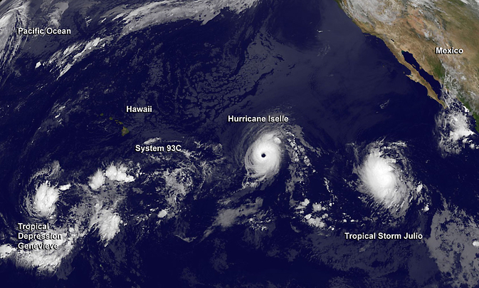
NOAA's GOES-West satellite captured this image of a very active Eastern and Central Pacific on August 4, hosting three tropical cyclones (from left to right) Genevieve, Iselle and Julio. Image credit: NASA/NOAA GOES Project
Genevieve strengthens into a hurricane, becomes a Super-Typhoon
Satellite data on Tuesday, August 5 showed that the structure of Genevieve has improved rapidly into a hurricane. At 15:00 UTC, the center of Tropical Storm Genevieve was located about 1 065 miles (1 710 km) south of Midway Island and about 555 miles (895 km) west-southwest of Johnston Island.
CPHC noted that Hurricane "Genevieve" was moving toward the west-northwest near 17 mph (28 km/h) and that this motion was expected to continue through Thursday. Maximum sustained winds were near 75 mph (120 km/h) and Genevieve was expected to become a typhoon in the west Pacific in the next day or two.
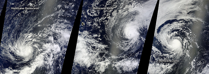
On August 5, at 22:05 UTC NASA's Terra satellite passed over Hurricane Genevieve (left), Hurricane Iselle (center), and Hurricane Julio (right) in the Central and Eastern Pacific Oceans. Image credit: NASA Goddard MODIS Rapid Response Team
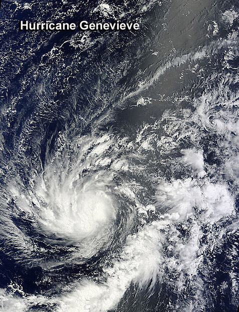
NASA's Terra satellite passed over Hurricane Genevieve on August 5 in the Central Pacific Ocean. Image Credit: NASA Goddard MODIS Rapid Response Team
Finally, after many ups and downs, once the storm crossed the International Dateline in the Pacific on Thursday, August 7 it rapidly intensified into a Super-Typhoon.
NASA-NOAA's Suomi NPP satellite captured the storm on August 7 at 01:48 UTC and its Visible Infrared Imaging Radiometer Suite (VIIRS) image showed a symmetrical storm with a clear eye, about 15 nautical miles (17.2 miles/27.7 km) wide, surrounded by powerful thunderstorms.
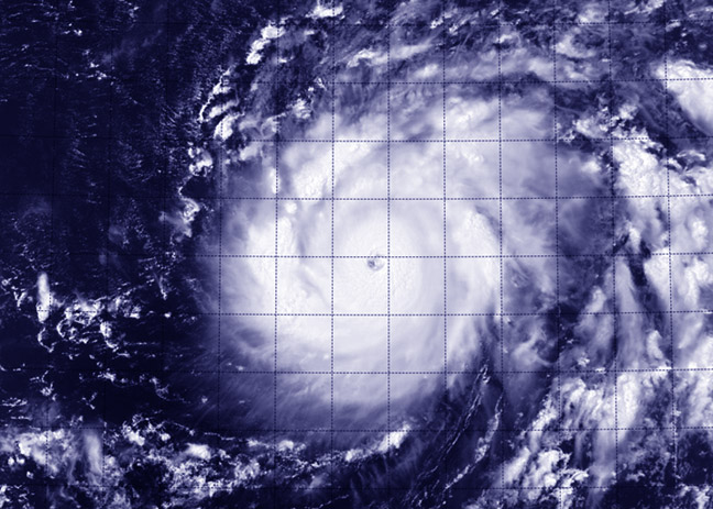
This visible image of Super-Typhoon Genevieve was taken from the VIIRS instrument aboard NASA-NOAA's Suomi NPP satellite on August 7 at 01:34 UTC. Image credit: NASA/NOAA
On August 7 at 12:00 UTC Super-Typhoon Genevieve's maximum sustained winds were near 140 knots (161.1 mph/259.3 km/h). Genevieve was a Category 5 typhoon on the Saffir-Simpson Hurricane Wind Scale. It was located approximately 692 nautical miles (796 miles/1 282 km) west of Johnston Island.
The Joint Typhoon Warning Center noted "Genevieve has rapidly intensified over the past 24 hours." The storm's maximum sustained winds have increased by 75 knots (126.6 mph/ 138.9 km/h), pushing the storm from 65 knots (74.3 mph/120.4 km/h) to 140 knots (161.1 mph/259.3 km/h).
When NASA's Tropical Rainfall Measuring Mission or TRMM satellite passed over Genevieve that day, data showed that there was a band of thunderstorms over the southern quadrant of the storm some 60 nautical miles (69 miles/111 km) thick.
The forecast called for Genevieve to maintain super typhoon strength over the next day and a half as it turns from a west-northwesterly track to a more northerly track over open ocean.
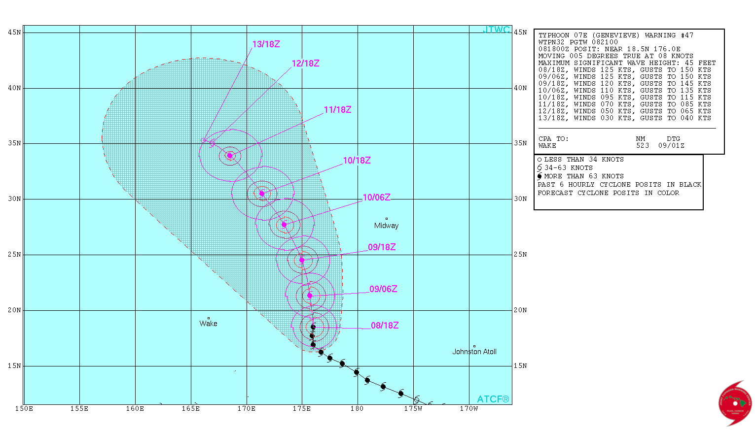
Typhoon "Genevieve" forecast track by JTWC on August 8, 2014.
By 21:00 UTC on August 8, Genevieve has again lost some its strength and is now a Category 4 typhoon located aproximately 836 nautical miles (962 miles/1 548 km) west of Johnston Island. It has tracked northwestward at 08 knots (9.2 mph/14.8 km/h) over the past six hours. Maximum significant wave height at 18:00 UTC today was 45 feet (13.71 meters).
It is now a tightly wrapped system with a 15 nautical miles (17.2 miles/27.7 km) wide eye. It is expected that Genevieve gradually weakens over the next three days but there is a high degree of uncertainty in the track forecast due to a complex steering environment.
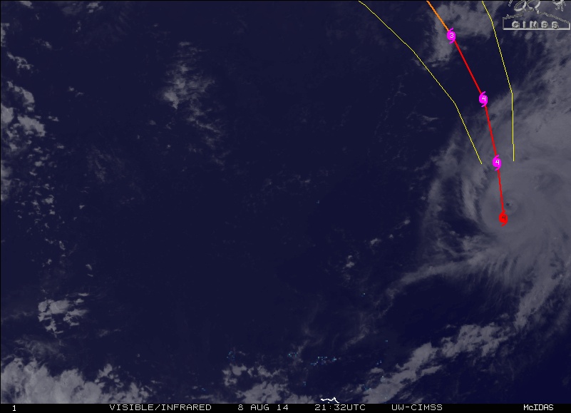
Visible/infrared image of Typhoon "Genevieve" on August 8, 2014 at 21:32 UTC. Image credit: UW-CIMSS
Analysis and images: NASA/Goddard, NOAA, JTWC, UW-CIMSS; Data: JTWC, NOAA/NHC
Featured image credit: NASA / NOAA GOES project
Don't be to shock scientist, it is only God.